Smoke from Mendocino Complex fires in California
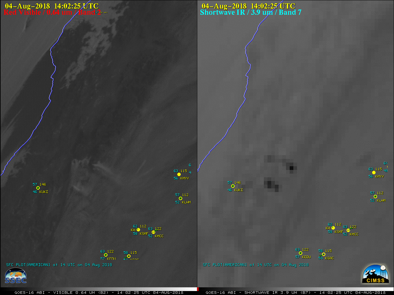
GOES-16 “Red” Visible (0.64 µm, left) and Shortwave Infrared (3.9 µm, right) images, with hourly plots of surface observations [click to play animation | MP4]
A 30-meter resolution Landsat-8 False Color Red-Green-Blue (RGB) image viewed using RealEarth (below) showed active burning along the eastern edge of the Ranch Fire (part of the Mendocino Complex) at 1845 UTC. The larger fire was producing a pyrocumulus cloud in addition to the dense smoke plume drifting northeastward.
![Landsat-8 False Color image [click to enlarge]](https://cimss.ssec.wisc.edu/satellite-blog/wp-content/uploads/sites/5/2018/08/180804_1845utc_landsat8_falsecolor_Mendocino_Complex_CA_fire.jpeg)
Landsat-8 False Color RGB image [click to enlarge]
![GOES-16 Upper-level (6.2 µm, top left), Mid-level (6.9 µm, top right), Low-level (7.3 µm, bottom left) Water Vapor and "Red" Visible with Derived Motion Winds (0.64 µm, bottom right) [click to play MP4 animation]](https://cimss.ssec.wisc.edu/satellite-blog/wp-content/uploads/sites/5/2018/08/CA_4panel_dmw-20180804_220225.png)
GOES-16 Upper-level (6.2 µm, top left), Mid-level (6.9 µm, top right), Low-level (7.3 µm, bottom left) Water Vapor images and “Red” Visible (0.64 µm, bottom right) images with Derived Motion Winds [click to play MP4 animation]
===== 07 August Update =====
![NOAA-20 VIIRS Day/Night Band (0.7 µm), Near-Infrared (1.61 µm and 2.25 µm) and Shortwave Infrared (3.75 µm) images [click to enlarge]](https://cimss.ssec.wisc.edu/satellite-blog/wp-content/uploads/sites/5/2018/08/180807_1001utc_noaa20_viirs_Mendocino_Complex_anim.gif)
NOAA-20 VIIRS Day/Night Band (0.7 µm), Near-Infrared (1.61 µm and 2.25 µm) and Shortwave Infrared (3.75 µm) images [click to enlarge]