Air France Flight #447: did weather play a role in the accident?
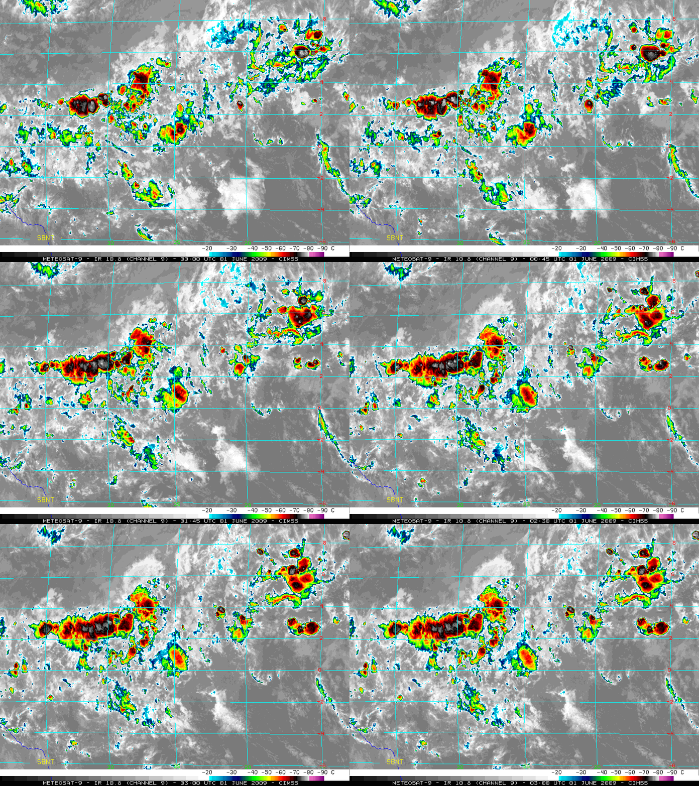
An Air France Airbus A330-200 — Flight #447 en route from Rio de Janeiro, Brazil to Paris, France — crashed in the tropical Atlantic Ocean on 01 June 2009 (surface analysis). Shortly after the last radio contact about 350 miles (565 km) northeast of Natal, Brazil (station identifier SBNT), the aircraft likely traversed an area of intense deep convection which had formed within a broad band of high total precipitable water along the Intertropical Convergence Zone (ITCZ). This convection could be seen on EUMETSAT Meteosat-9 10.8 µm IR images (above) in the region between 2º N to 4º N latitude and 25º W to 35º W longitude. Some of the individual convective clusters appeared to be developing very quickly — this leads to speculation that turbulence in the vicinity of these rapidly-developing storms may have played a role in the accident.
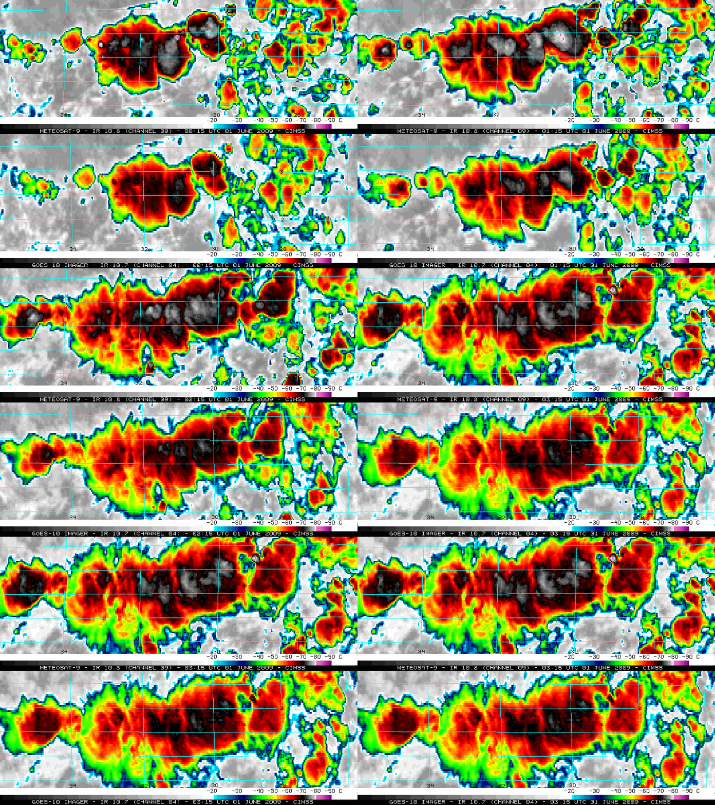
A closer look at the ITCZ convection is shown using Meteosat-9 IR imagery with a magnification factor of 2 (below; also available as a QuickTime animation). There were a number of times when the minimum cloud top IR brightness temperature was -80º C or colder (light purple color enhancement), with the coldest cloud top temperature of -82º C occurring at 00:15 UTC. While this is certainly a cold cloud top temperature value, it cannot be considered “extreme” by any means: cloud top temperatures in tropical weather systems have been known reach -90º C or colder on occasion.
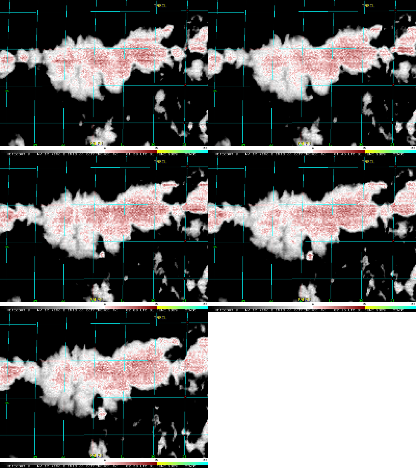
Air France Flight 447 last radioed their position at the “INTOL” waypoint at 01:33 UTC, and according to their flight plan they were then supposed to proceed to the “SALPU” and the “ORARO” waypoints along Airway UN873. At the INTOL waypoint, they communicated that they expected to reach the “TASIL” waypoint around 02:20 UTC (these waypoints are labeled on the IR images below). During the 02:10-02:14 UTC timeframe, a series of automated ACARS fault messages was transmitted by the aircraft when it was approximately 54 miles from reaching the TASIL waypoint (the aircraft had possibly just cleared the northern fringes of the band of ITCZ convection around that time).
The brightness temperature difference values between the Meteosat-9 water vapor and IR window channels (6.2 µm – 10.8 µm) were calculated in an effort to try and highlight the most vigorous areas of convective development (below). The assumption is that when intense convection overshoots the tropopause into the warmer stratosphere, the water vapor that is pushed above the cloud top emits radiation at a warmer temperature than the actual cloud top below. Many pixels in the band of ITCZ convection exhibited WV-IR brightness temperature difference values in the 3-5º C range (darker red color enhancement). Of particular interest is the comparatively small cluster of convection that developed very rapidly around 02:00 UTC, near 1.75º N latitude and 31.7º West longitude (north of waypoint “SALPU”) — this cluster of convection exhibited WV-IR brightness temperature difference values as high as 4º C at 02:15 UTC. Could this rapidly-developing convective cell have generated severe turbulence that affected Air France flight 447 as it was passing nearby, en route to waypoint “TASIL”?
A comparison of the 3-km resolution Meteosat-9 10.8 µm IR and the 4-km resolution GOES-10 10.7 µm IR images (below; magnified to an effective resolution of 1 km) shows that the cloud top IR brightness temperatures generally appeared to be about 3-6º C warmer on the GOES-10 imagery — the coldest GOES-10 IR brightness temperature was -77º C at 01:15 UTC. The coarser 4-km GOES-10 IR pixel resolution tended to “smooth out” the small-scale temperature structure of the cold cloud tops; therefore, a finer cloud top temperature structure was apparent on the 3-km resolution Meteosat-9 IR imagery.
The 00:00 UTC rawinsonde report from Fernando de Noronha, Brazil (below) indicated that the tropical tropopause level was probably located near the 100 hPa pressure level (at a height of 16,649 meters, or 54,623 feet), where the minimum temperature was -77.7º C. The presence of cloud top IR brightness temperatures colder than -80º C on the Meteosat-9 imagery suggests that many of the strongest updrafts were likely penetrating the tropopause — and such overshooting thunderstorm updrafts have been known to initiate strong gravity waves aloft that have generated moderate to severe turbulence.
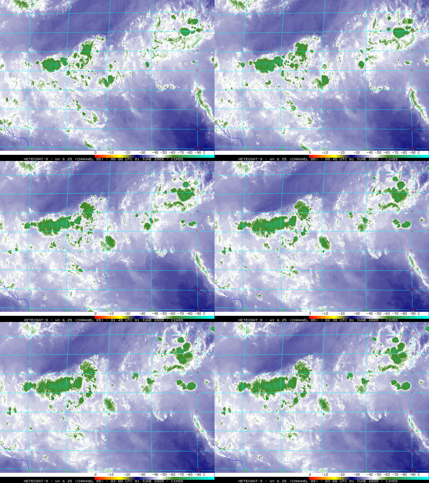
Meteosat-9 6.25 µm “water vapor channel” images (below) showed none of the typical water vapor signatures associated with turbulence in the immediate region of the ITCZ convection — however, it did indicate the presence of a southwestward-propagating wave (located between 7-8º N latitude and 35-40º W longitude) that appeared to be responsible for initiating the formation of a patch of high clouds near 8º N 38º W. The water vapor imagery depicted a region of drier mid-tropospheric air immediately to the north of the ITCZ convection, suggesting synoptic-scale subsidence aloft in that area. Also note that within this region of drier air to the north of the ITCZ there was an interesting pattern of subtle impulses which were propagating westward.
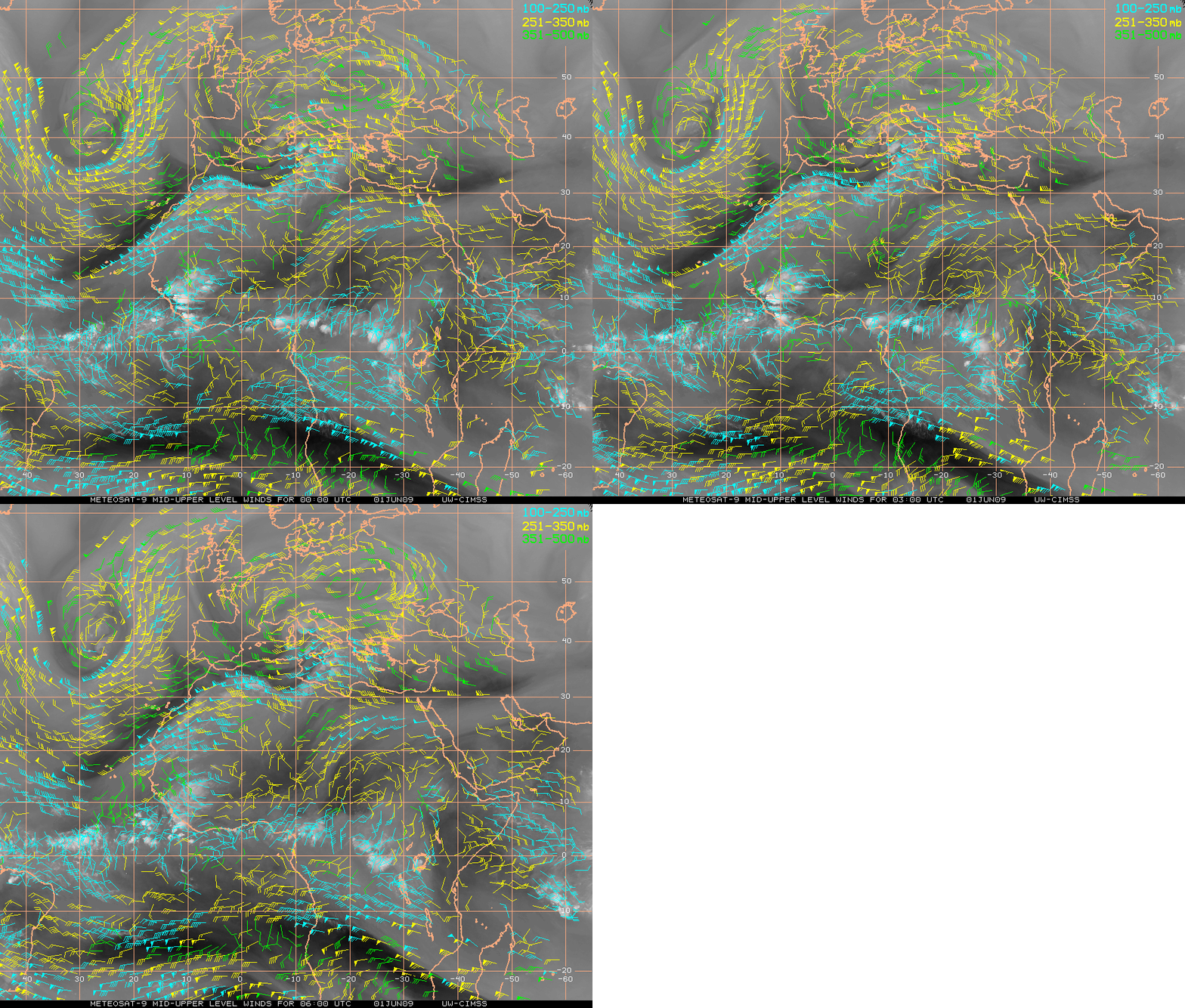
Meteosat-9 water vapor winds from the CIMSS Tropical Cyclones site valid at 00:00, 03:00, and 06:00 UTC (below) showed that the upper tropospheric winds were weakly divergent over area of the ITCZ convection (150-300 hPa divergence plot), with only a minimal amount (5-10 knots) of deep layer wind shear in that particular region. The water vapor imagery also depicted a “dry/moist gradient” signature associated with a subtropical jet stream which was moving over the northwestern coast of Africa — while the deep layer wind shear was increasing between the ITCZ convection and the subtropical jet (to a maximum value exceeding 60 knots), it is questionable whether the aircraft made it far enough to the northeast to be affected in any way by this increasing wind shear.
===========================================
See also:
Air France Flight 447: A detailed meteorological analysis


