Tropical Storm Cindy
![GOES-16 Visible (0.64 µm, left) and Infrared Window (10.3 µm, right) images, with hourly surface//ship/buoy reports plotted in yellow [click to play MP4 animation]](https://cimss.ssec.wisc.edu/satellite-blog/wp-content/uploads/sites/5/2017/06/958x638_GOES16A_B213_G16_VIS_IR_PTC3_20JUN2017_2017171_120057_0002PANELS.GIF)
GOES-16 Visible (0.64 µm, left) and Infrared Window (10.3 µm, right) images, with hourly surface//ship/buoy reports plotted in yellow [click to play MP4 animation]
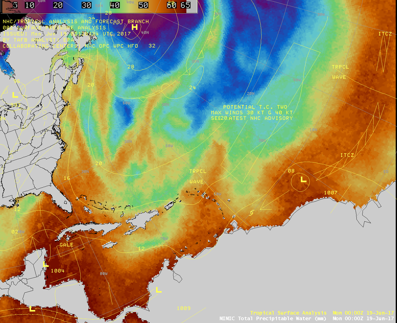
As Tropical Storm Bret was forming off the coast of South America, Potential Tropical Cyclone 3 (PTC3) was becoming more organized as it moved from the western Caribbean Sea across the Yucatan Peninsula of Mexico and into the Gulf of Mexico on 19 June 2017 (MIMIC TPW). On 20 June, one of the GOES-16 Mesoscale Sectors was positioned over PTC3 and provided 1-minute imagery — Visible (0.64 µm) and Infrared Window (10.3 µm) images (above) showed deep convective bursts moving northward to reveal an exposed Low Level Circulation Center (LLCC).
![GOES-16 Visible (0.64 µm, left) and Infrared Window (10.3 µm, right) images, with hourly surface/buoy/ship reports plotted in yellow [click to play MP4 animation]](https://cimss.ssec.wisc.edu/satellite-blog/wp-content/uploads/sites/5/2017/06/958x638_GOES16A_B213_G16_VIS_IR_CINDY_21JUN2017_2017172_161757_0002PANELS.GIF)
GOES-16 Visible (0.64 µm, left) and Infrared Window (10.3 µm, right) images, with hourly surface/buoy/ship reports plotted in yellow [click to play MP4 animation]
![GOES-16 Visible (0.64 µm, left) and Water Vapor (6..9 µm, right) images [click to play MP4 animation]](https://cimss.ssec.wisc.edu/satellite-blog/wp-content/uploads/sites/5/2017/06/958x638_GOES16A_B29_G16_VIS_WV_CINDY_21JUN2017_2017172_153719_0002PANELS.GIF)
GOES-16 Visible (0.64 µm, left) and Water Vapor (6..9 µm, right) images [click to play MP4 animation]
![Suomi NPP VIIRS Visible (0.64 µm) and Infrared Window (11.45 µm) images, with surface pressure plotted in yellow and station identifiers plotted in cyan [click to enlarge]](https://cimss.ssec.wisc.edu/satellite-blog/wp-content/uploads/sites/5/2017/06/170621_1911utc_suomi_npp_viirs_visible_infrared_TS_Cindy_anim.gif)
Suomi NPP VIIRS Visible (0.64 µm) and Infrared Window (11.45 µm) images, with surface pressure plotted in yellow and station identifiers plotted in cyan [click to enlarge]
![MIMIC Total Precipitable Water [click to play animation]](https://cimss.ssec.wisc.edu/satellite-blog/wp-content/uploads/sites/5/2017/06/170619-24_mimic_tpw_Cindy_anim.gif)
MIMIC Total Precipitable Water [click to play animation]
![21-24 June daily precipitation, along with 7-day Precipitation Total, 7-day Departure from Normal and 7-day Percent of Normal [click to enlarge]](https://cimss.ssec.wisc.edu/satellite-blog/wp-content/uploads/sites/5/2017/06/170621-24_Cindy_precip_departure_percent_anim.gif)
21-24 June daily precipitation, along with 7-day Precipitation Total, 7-day Departure from Normal and 7-day Percent of Normal [click to enlarge]