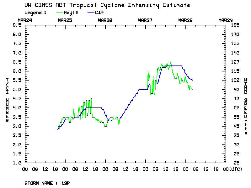
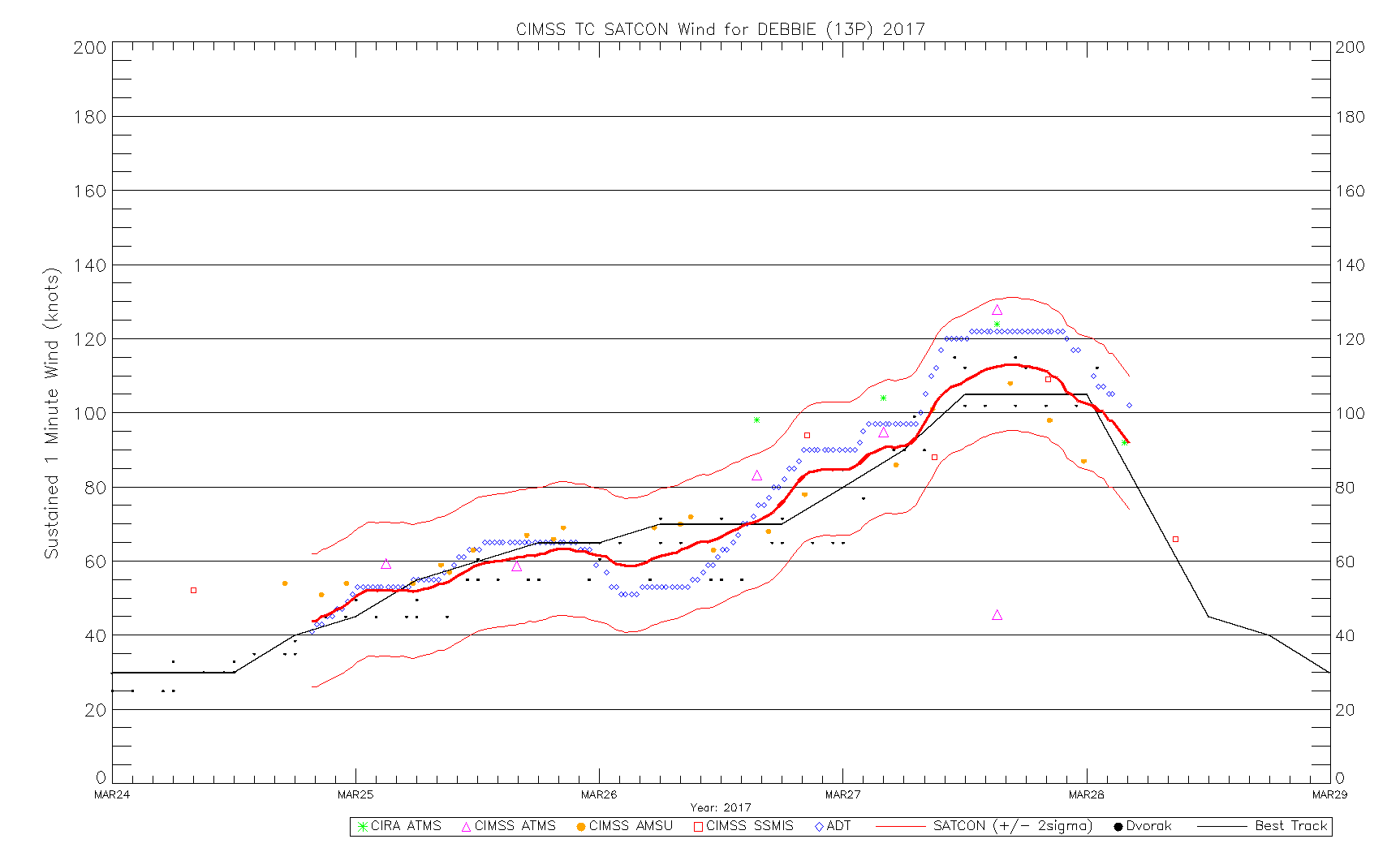
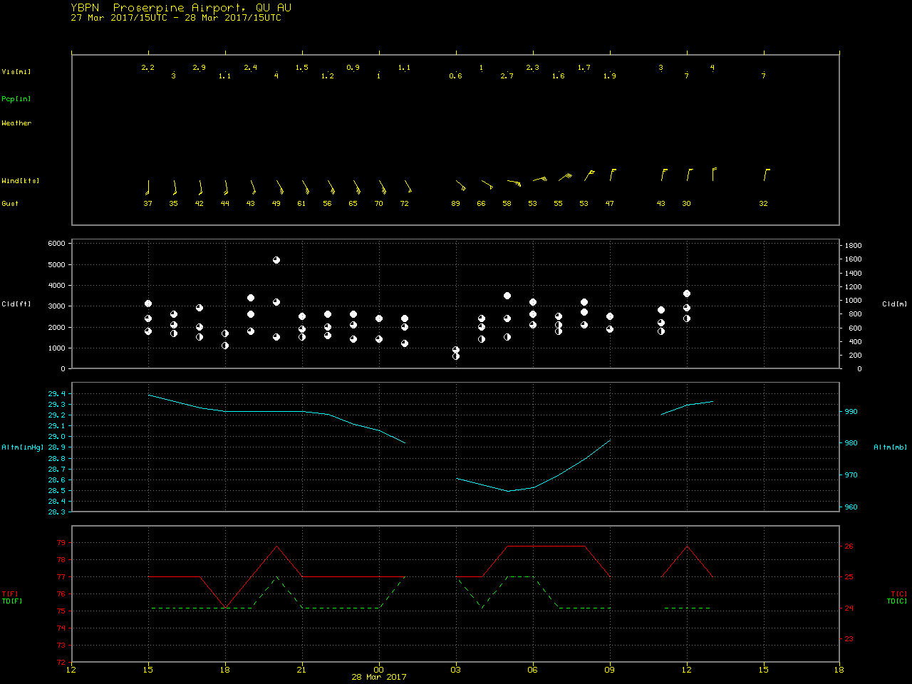
Cyclone Debbie makes landfall in Queensland, Australia
![Himawari-8 Visible (0.64 µm) and Infrared Window (10.4 µm) images [click to play animation]](https://cimss.ssec.wisc.edu/satellite-blog/wp-content/uploads/sites/5/2017/03/170327_himawari8_vis_ir_Cyclone_Debbie_anim.gif)
Himawari-8 Visible (0.64 µm) and Infrared Window (10.4 µm) images [click to play animation]
![Landsat-8 false-color, with Himawari-8 Visible (0.64 µm) and Infrared Window (10.4 µm) images [click to enlarge]](https://cimss.ssec.wisc.edu/satellite-blog/wp-content/uploads/sites/5/2017/03/170326_2358utc_landsat8_falsecolor_himawari8_visible_infrared_Cyclone_Debbie_anim.gif)
Landsat-8 false-color, with Himawari-8 Visible (0.64 µm) and Infrared Window (10.4 µm) images [click to enlarge]
![Himawari-8 Infrared Window (10.4 µm) and GMI Microwave (85 GHZ) Images around 1430 UTC on 27 March [click to enlarge]](https://cimss.ssec.wisc.edu/satellite-blog/wp-content/uploads/sites/5/2017/03/170327_1426utc_gmi_microwave_1430_utc_himawari8_infrared_Cyclone_Debbie_anim.gif)
Himawari-8 Infrared Window (10.4 µm) and GMI Microwave (85 GHZ) Images around 1430 UTC on 27 March [click to enlarge]
![Himawari-8 Infrared Window (10.4 µm) and DMSP-18 SSMIS Microwave (85 GHz) images around 2017 UTC on 27 March [click to enlarge]](https://cimss.ssec.wisc.edu/satellite-blog/wp-content/uploads/sites/5/2017/03/170327_2017utc_dmsp18_microwave_2000utc_himawari8_ir_Cyclone_Debbie_anim.gif)
Himawari-8 Infrared Window (10.4 µm) and DMSP-18 SSMIS Microwave (85 GHz) images around 2017 UTC on 27 March [click to enlarge]
![MIMIC Total Precipitable Water product [click to play animation]](https://cimss.ssec.wisc.edu/satellite-blog/wp-content/uploads/sites/5/2017/03/170325-31_mimic_tpw_Cyclone_Debbie_anim.gif)
MIMIC Total Precipitable Water product [click to play animation]