Cold temperatures in Alaska
![NOAA-18 AVHRR Infrared Window (10.8 µm) image, with surface air temperatures and corresponding station identifications [click to enlarge]](https://cimss.ssec.wisc.edu/satellite-blog/wp-content/uploads/sites/5/2017/01/170118_1916utc_noaa18_avhrr_infrared_surface_air_temperatures_AK_large_anim.gif)
NOAA-18 AVHRR Infrared Window (10.8 µm) image, with surface air temperatures and corresponding station identifications [click to enlarge]
It’s cold over parts of Alaska, but it’s not approaching record low levels. Many of these records were set in 1947. #akwx @Climatologist49 pic.twitter.com/ssWq0ZhV09
— Rick Thoman (@AlaskaWx) January 19, 2017
![NOAA-18 AVHRR Infrared Window (10.8 µm) image centered on Bettles (PABT), with surface air temperatures and corresponding station identifications [click to enlarge]](https://cimss.ssec.wisc.edu/satellite-blog/wp-content/uploads/sites/5/2017/01/170118_1916utc_noaa18_avhrr_infrared_surface_air_temperatures_AK_PABT_anim.gif)
NOAA-18 AVHRR Infrared Window (10.8 µm) image centered on Bettles (PABT), with surface air temperatures and corresponding station identifications [click to enlarge]
![NOAA-18 AVHRR Infrared Window (10.8 µm) image centered on Tanana (PATA), with surface air temperatures and corresponding station identifications [click to enlarge]](https://cimss.ssec.wisc.edu/satellite-blog/wp-content/uploads/sites/5/2017/01/170118_1916utc_noaa18_avhrr_infrared_surface_air_temperatures_AK_PATA_anim.gif)
NOAA-18 AVHRR Infrared Window (10.8 µm) image centered on Tanana (PATA), with surface air temperatures and corresponding station identifications [click to enlarge]
=================================================================
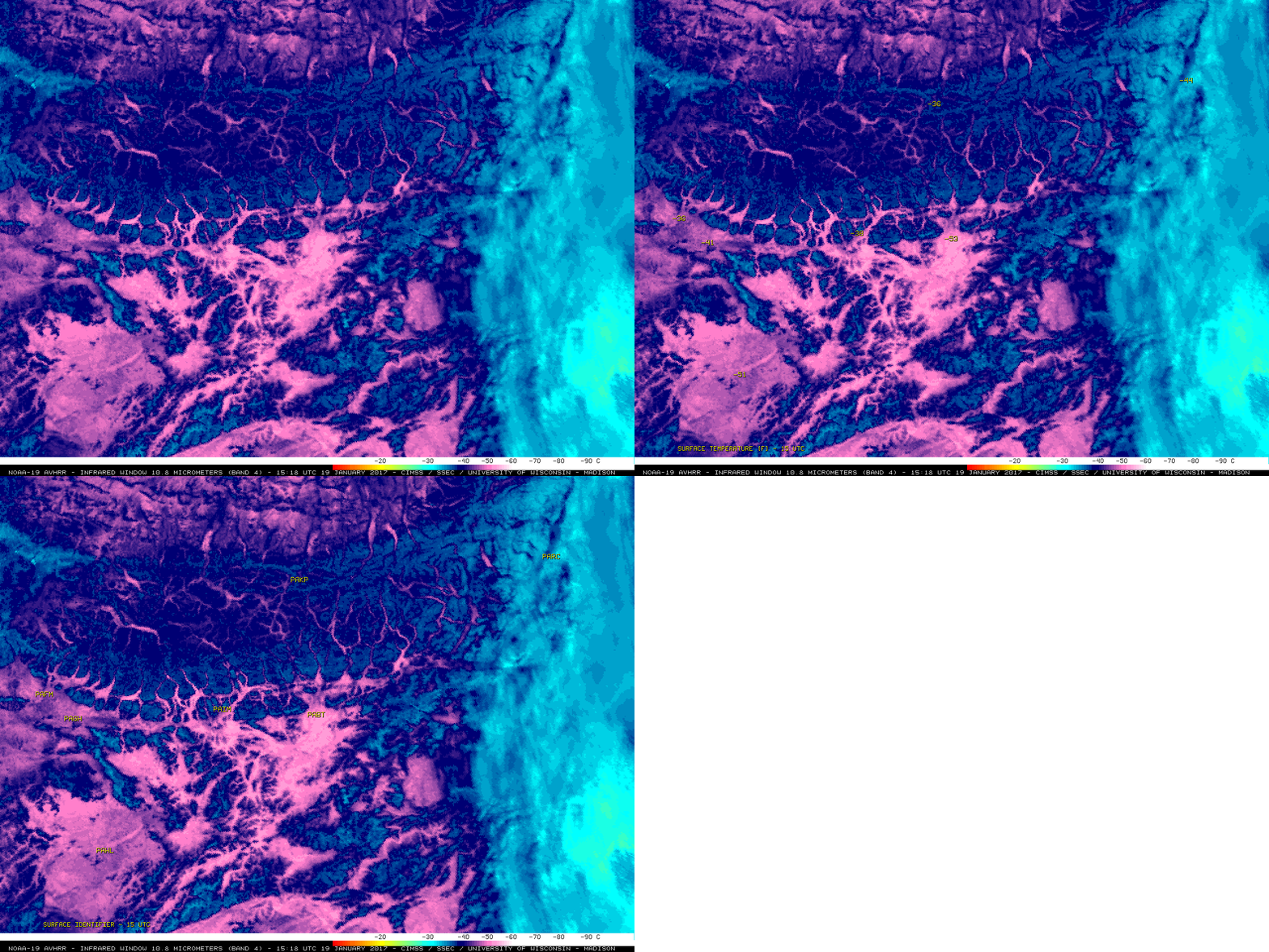
![NOAA-19 AVHRR Infrared Window (10.8 µm) image, with surface air temperatures and corresponding station identifications [click to enlarge]](https://cimss.ssec.wisc.edu/satellite-blog/wp-content/uploads/sites/5/2017/01/170119_1518utc_noaa19_avhrr_infrared_surface_air_temperatures_AK_LARGE_anim.gif)
NOAA-19 AVHRR Infrared Window (10.8 µm) image, with surface air temperatures and corresponding station identifications [click to enlarge]

NOAA-19 AVHRR Infrared Window (10.8 µm) image centered on Bettles (PABT), with surface air temperatures and corresponding station identifications [click to enlarge]


![NOAA-18 vs GOES-15 Infrared Window images [click to enlarge]](https://cimss.ssec.wisc.edu/satellite-blog/wp-content/uploads/sites/5/2017/01/170118_0915utc_noaa18_goes15_infrared_Alaska_cold_anim.gif)
![NOAA-19 AVHRR Infrared Window (10.8 µm) images centered on Tanana (PATA), with surface air temperatures and corresponding station identifications [click to enlarge]](https://cimss.ssec.wisc.edu/satellite-blog/wp-content/uploads/sites/5/2017/01/170119_1518utc_noaa19_avhrr_infrared_surface_air_temperatures_AK_PATA_anim.gif)