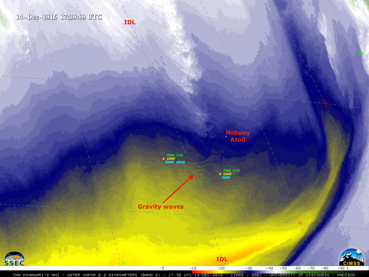
Moderate to severe turbulence aloft near the International Date Line
![Himawari-8 Water Vapor (6.2 µm) images, with pilot reports of turbulence [click to play animation]](https://cimss.ssec.wisc.edu/satellite-blog/wp-content/uploads/sites/5/2016/12/161214_himawari8_water_vapor_band_8_Dateline_TB_pireps_anim.gif)
Himawari-8 Water Vapor (6.2 µm) images, with pilot reports of turbulence [click to play animation]
PHNL UUA /OV 2800N 18000W/TM 1530/FL380/TP B767/TB MOD-SEV/RM ZOA CWSU
PHNL UUA /OV 2643N 17757W/TM 1732/FL350/TP A330/TB SEV/RM ZOA CWSU
PHNL UUA /OV 2626N 17917W/TM 1740/FL360/TP B747/TB SEV/RM ZOA CWSU
A larger-scale view using all 3 water vapor bands of the AHI instrument on the Himawari-8/9 satellites (below; also available as an MP4 animation) showed that a broad trough was moving eastward away from the International Date Line, with the signature of a jet streak diving southward toward the region of the turbulence reports (Note: the ABI instrument on the GOES-R series of satellites will feature these same 3 upper level, mid-level and lower level water vapor bands).
![Himawari-8 Water Vapor (6.2 µm, top; 6.9 µm, middle; 7.4 µm, bottom) images [click to play animation]](https://cimss.ssec.wisc.edu/satellite-blog/wp-content/uploads/sites/5/2016/12/161214_himawari8_water_vapor_Dateline_TB_anim.gif)
Himawari-8 Water Vapor (6.2 µm, top; 6.9 µm, middle; 7.4 µm, bottom) images [click to play animation]
——————————————————————————–
![Himawari-8 water vapor image Derived Motion Winds at 12 UTC, with corresponding contours of Upper-tropospheric divvergence [click to enlarge]](https://cimss.ssec.wisc.edu/satellite-blog/wp-content/uploads/sites/5/2016/12/161214_12utc_water_vapor_winds_upper_divergence_anim.gif)
Himawari-8 water vapor image Derived Motion Winds at 12 UTC, with corresponding contours of Upper-tropospheric divvergence [click to enlarge]
![Himawari-8 water vapor image Derived Motion Winds at 15 UTC, with corresponding contours of Upper-tropospheric divergence [click to enlarge]](https://cimss.ssec.wisc.edu/satellite-blog/wp-content/uploads/sites/5/2016/12/161214_15utc_water_vapor_winds_upper_divergence_anim.gif)
Himawari-8 water vapor image Derived Motion Winds at 15 UTC, with corresponding contours of Upper-tropospheric divergence [click to enlarge]
![Himawari-8 water vapor image Derived Motion Winds at 18 UTC, with corresponding contours of Upper-tropospheric divergence [click to enlarge]](https://cimss.ssec.wisc.edu/satellite-blog/wp-content/uploads/sites/5/2016/12/161214_18utc_water_vapor_winds_upper_divergence_anim.gif)
Himawari-8 water vapor image Derived Motion Winds at 18 UTC, with corresponding contours of Upper-tropospheric divergence [click to enlarge]
![Himawari-8 Water Vapor (6.2 µm, left) and GOES-15 Water Vapor (6.5 µm, right) images, with pilot reports of turbulence [click to play animation]](https://cimss.ssec.wisc.edu/satellite-blog/wp-content/uploads/sites/5/2016/12/161214_himawari8_goes15_water_vapor_Dateline_Turbulence_anim.gif)
Himawari-8 Water Vapor (6.2 µm, left) and GOES-15 Water Vapor (6.5 µm, right) images, with pilot reports of turbulence [click to play animation]
![Himawari-8 Water Vapor (6.2 µm) image at 1530 UTC, as viewed using 8-bit McIDAS-X (left) and 11-bit McIDAS-V (right) displays [click to enlarge]](https://cimss.ssec.wisc.edu/satellite-blog/wp-content/uploads/sites/5/2016/12/161214_1530utc_himawari8_water_vapor_band8_McX_8bit_McV_11bit.jpg)
Himawari-8 Water Vapor (6.2 µm) image at 1530 UTC, as viewed using 8-bit McIDAS-X (left) and 11-bit McIDAS-V (right) displays [click to enlarge]