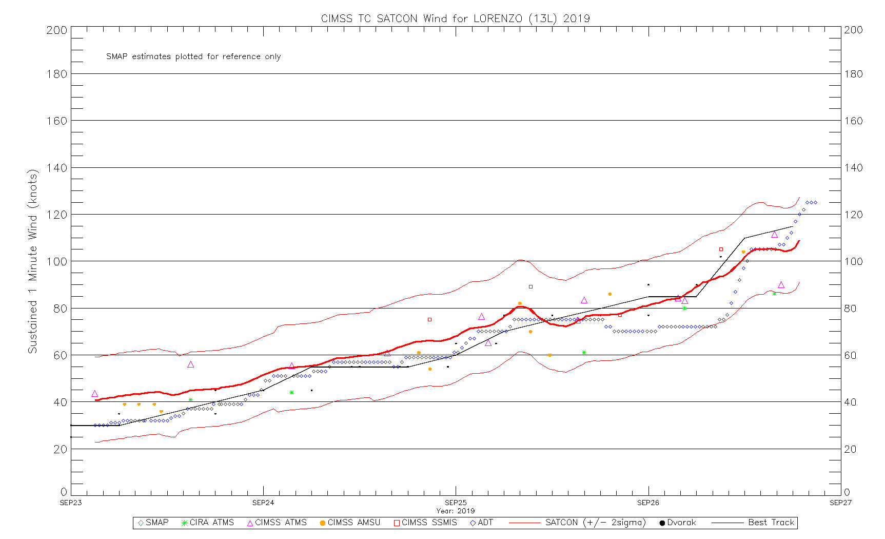
Hurricane Lorenzo in the Atlantic Ocean
![GOES-16 “Clean” Infrared Window (10.35 µm) images [click to play animation | MP4]](https://cimss.ssec.wisc.edu/satellite-blog/wp-content/uploads/sites/5/2019/09/190926_goes16_infrared_Lorenzo_anim.gif)
GOES-16 “Clean” Infrared Window (10.35 µm) images [click to play animation | MP4]
A toggle between VIIRS True Color Red-Green-Blue (RGB) and Infrared Window (11.45 µm) images from Suomi NPP and NOAA-20 as viewed using RealEarth (below) provided a detailed view of the eye and eyewall region of Lorenzo at 1542 UTC and 1632 UTC. On the Suomi NPP Infrared image, note the transverse banding northwest of the eye, and a small packet of gravity waves southwest of the eye.
![VIIRS True Color RGB and Infrared Window<em> (11.45 µm)</em> images from Suomi NPP and NOAA-20 [click to enlarge]](https://cimss.ssec.wisc.edu/satellite-blog/wp-content/uploads/sites/5/2019/09/190926_15utc_suomiNPP_16utc_noaa20_viirs_trueColorRGB_infraredWindow_Lorenzo_anim.gif)
VIIRS True Color RGB and Infrared Window (11.45 µm) images from Suomi NPP (at 1542 UTC) and NOAA-20 (at 1632 UTC) [click to enlarge]
![DMSP-18 SSMIS Microwave (85 GHz) image at 1941 UTC [click to enlarge]](https://cimss.ssec.wisc.edu/satellite-blog/wp-content/uploads/sites/5/2019/09/190926_1941utc_dmsp18_ssmis_microwave_Lorenzo.png)
DMSP-18 SSMIS Microwave (85 GHz) image at 1941 UTC [click to enlarge]