Above-Anvil Cirrus Plume (AACP) over Argentina
We are down for @RELAMPAGO2018, but #ARMCACTI just captured dual frequency radar observations of above anvil cirrus plume associated with an overshooting top @krisbedka @AtmoScientist @murillomojo pic.twitter.com/lC3GOPWCMu
— Steve Nesbitt (@70_dbz) November 3, 2018
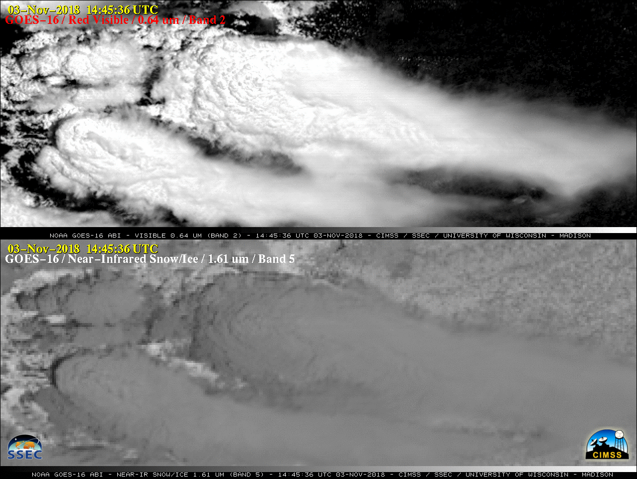
An Above-Anvil Cirrus Plume (AACP) was observed over northern Argentina on 03 November 2018 during the RELAMPAGO-CACTI field experiment — radar indicated that the plume was 2-3 km above the top of the main thunderstorm anvil. A comparison of GOES-16 (GOES-East) “Red” Visible (0.64 µm), Near-Infrared “Snow/Ice” (1.61 µm) and “Clean” Infrared Window (10.3 µm) images (below) showed that the plume exhibited a colder appearance compared to the underlying anvil (which is explained by the temperature profile from 12 UTC Cordoba rawinsonde data). GOES-16 was actually scanning the AACP at 14:38:41 UTC — very close to the time of the radar image. The plume-producing thunderstorm was located south of Cordoba (identifier SACO).
![GOES-16 "Red" Visible (0.64 µm), Near-Infrared "Snow/Ice" (1.61 µm) and "Clean" Infrared Window (10.3 µm) images [click to enlarge]](https://cimss.ssec.wisc.edu/satellite-blog/wp-content/uploads/sites/5/2018/11/181103_1430utc_goes16_visible_nearInfrared_infraredWindow_SACO_AACP_anim.gif)
GOES-16 “Red” Visible (0.64 µm), Near-Infrared “Snow/Ice” (1.61 µm) and “Clean” Infrared Window (10.3 µm) images [click to enlarge]
![GOES-16 "Red" Visible (0.64 µm), Near-Infrared "Snow/Ice" (1.61 µm) images [click to play animation | MP4]](https://cimss.ssec.wisc.edu/satellite-blog/wp-content/uploads/sites/5/2018/11/181103_goes16_visible_snowIce_Argentina_AACP_anim.gif)
GOES-16 “Red” Visible (0.64 µm) and Near-Infrared “Snow/Ice” (1.61 µm) images [click to play animation | MP4]
![GOES-16 "Red" Visible (0.64 µm) and "Clean" Infrared Window (10.3 µm) images [click to play animation | MP4]](https://cimss.ssec.wisc.edu/satellite-blog/wp-content/uploads/sites/5/2018/11/181103_goes16_visible_infrared_Argentina_AACP_anim.gif)
GOES-16 “Red” Visible (0.64 µm) and “Clean” Infrared Window (10.3 µm) images [click to play animation | MP4]
![True Color RGB images from Terra MODIS (1457 UTC), Aqua MODIS (1736 UTC), Suomi NPP VIIRS (1742 UTC) and NOAA-20 VIIRS (1832 UTC) [click to enlarge]](https://cimss.ssec.wisc.edu/satellite-blog/wp-content/uploads/sites/5/2018/11/181103_modis_viirs_truecolor_SACO_anim.gif)
True Color RGB images from Terra MODIS (1457 UTC), Aqua MODIS (1736 UTC), Suomi NPP VIIRS (1742 UTC) and NOAA-20 VIIRS (1832 UTC) [click to enlarge]