General Requirement
ABS/HES will be an infrared Michelson interferometer or grating
Atmospheric Infrared Sounder (AIRS)
like sounder. The figure shows
the spectral coverage of the current GOES sounder bands, 3-waveband
ABS/HES (ABS prime in the figure) and 2-waveband GIFTS spectra.
ABS/HES radiance measurements, at varying spectral resolutions,
can be converted into atmospheric temperature, moisture and ozone
profiles. ABS/HES spectral resolution will resole individual carbon
dioxide absorption lines and should provide the high vertical resolution
soundings with the required accuracy.
ABS/HES will scan the region within 62 degrees local zenith angle
within one hour (see Figure)
although only scan half of the region of overlap between the eastern
and western satellites, nominally at 105W. The scan area shall
be selectable to offer flexible scan scenarios. This ranges from
meso-scale areas (1000 by 1000 km) through the size of the full
disk.
Sounder Comparison (GOES-Current to HES-req)
|
Current |
Requirement |
| Coverage Rate |
CONUS/hr |
Sounding Disk/hr |
| Horizontal Sampling Distance |
10 km |
10 km |
| Horizontal Individual Sounding |
30 - 50 km |
10 km |
| Vertical Resolution |
~3 km |
1 km |
| Temperature Accuracy |
2 deg. K |
1 deg. K |
| Relative Humidity Accuracy |
20% |
10% |
HES Task - Disk Sounding (HES-DS)
- Provide vertical moisture and temperature information, and
other environmental data that will be used by NOAA and other
public and private agencies to produce routine meteorological
analyses and forecasts
- Provide data that may be used to extend knowledge and understanding
of the atmosphere and its processes in order to improve
short/long-term weather forecasts.
HES Task - Severe Weather / Mesoscale (HES-SW/M)
- Provide environmental data that can be used to expand knowledge
of mesoscale and synoptic scale storm development and provide
data that may be used to help in forecasting severe weather events.
- Backup mode in the event of a GOES-R ABI failure (both).
- Spatial Resolution
IR: Threshold=4 km, Goal=2 km. Vis: Threshold=1.0 km, Goal=
0.5 km
- Coverage rate
1000 km x 1000 km (locations vary) in 4.4 minutes. Coverage
area must be flexible and selectable.
Expected scan times for the DS task sensor emissive bands
(HES bands 1-3)
| Coverage Region |
Coverage Area (km2) |
GSR
(Hz) |
GSD
(km) |
Within Frame Scan Efficiency |
Coverage Time |
| Full Disk |
1.00E+08 |
300 |
4 |
0.6 |
9 hr 38.7 min |
| 62-degree LZA |
7.00E+07 |
300 |
4 |
0.65 |
6 hr 46.0 min |
| CONUS |
1.50E+07 |
300 |
4 |
0.9 |
0 hr 57.9 min |
| Mesoscale |
1.00E+06 |
300 |
4 |
0.8 |
0 hr 4.3 min |
| Coastal Water |
2.40E+06 |
300 |
4 |
0.95 |
0 hr 8.8 min |
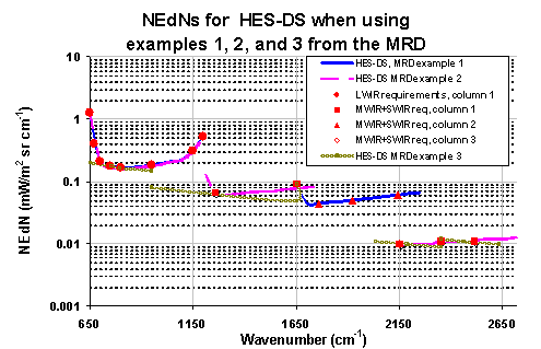
- Spectral coverage
Specific examples are cited in the MRD, same as HES-DS
- Spectral resolution:
- 15 um CO2 band: 0.6 cm-1,
- Windows: 0.6-1.0 cm-1,
- Ozone: 1 cm-1,
- H2O: 1-2 cm-1,
- near 4 um: 2.5 cm-1and
- Visible: 0.18 um
HES balance of temporal (30 min). spectral (0.5 cm-1),
spatial (2-10 km), and radiometric (0.1 K) capabilities will
- depict water vapor as never before by identifying small scale
features of moisture vertically and horizontally in the atmosphere
- track atmospheric motions much better by discriminating more
levels of motion and assigning heights more accurately
- characterize life cycle of clouds (cradle to grave) and distinguish
between ice and water cloud
- measure surface temperatures (land and sea) by accounting
for emissivity effects
- distinguish atmospheric constituents with improved certainty;
these include volcanic ash, ozone, and possibly other trace gases
 |