


"Thank you, GOES-8, for 9 years of service!"


Practical implications of GOES-8 improved (over GOES-7) observing capabilities for the Imager include: higher quality imagery acquired more frequently, better cloud and hurricane observations, better cloud drift and water vapor winds, detection of fog, enhanced land and sea surface temperature monitoring, improved detection of forest fires and biomass burning and polar viewing capability greatly enhanced. Click for more.
Practical implications of GOES-8 improved (over GOES-7) observing capabilities for the Sounder include: first operational geostationary sounder providing full time coverage (no untimely gaps), improved Sounder imagery, better depiction of changes in atmospheric moisture and stability, hourly clouds to supplement cloud surface reports and regional models, better depiction of boundary layer thermodynamics, higher quality thermal gradient winds, and first ever continuous monitoring of ozone. Click for more.
Firsts (top)
First Imager Image: 9 May 1994, 1630 UTC. Visible, Infrared, Water Vapor, Near-IR bands.
First Sounder Image : 6 June 1994, 1414 UTC. Infrared, Water Vapor, CO2 bands.


Environment and Hazards (top)
Fires (with ABBA): Louisiana and Texas on 5 September 2000. More information on this event.
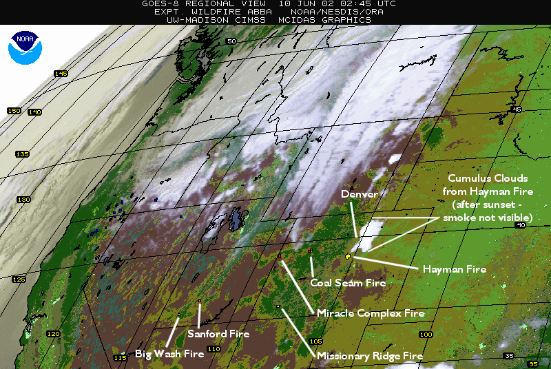
Fires (with ABBA): Western US wildfires, week of 9 June 2002. More information on this event.
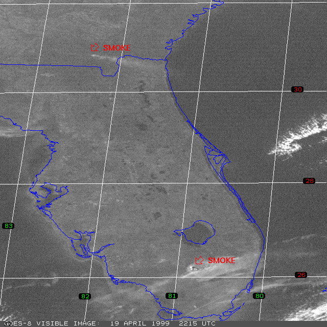
Fires: Florida on 19 April 1999, 2215 UTC. More information on this event.
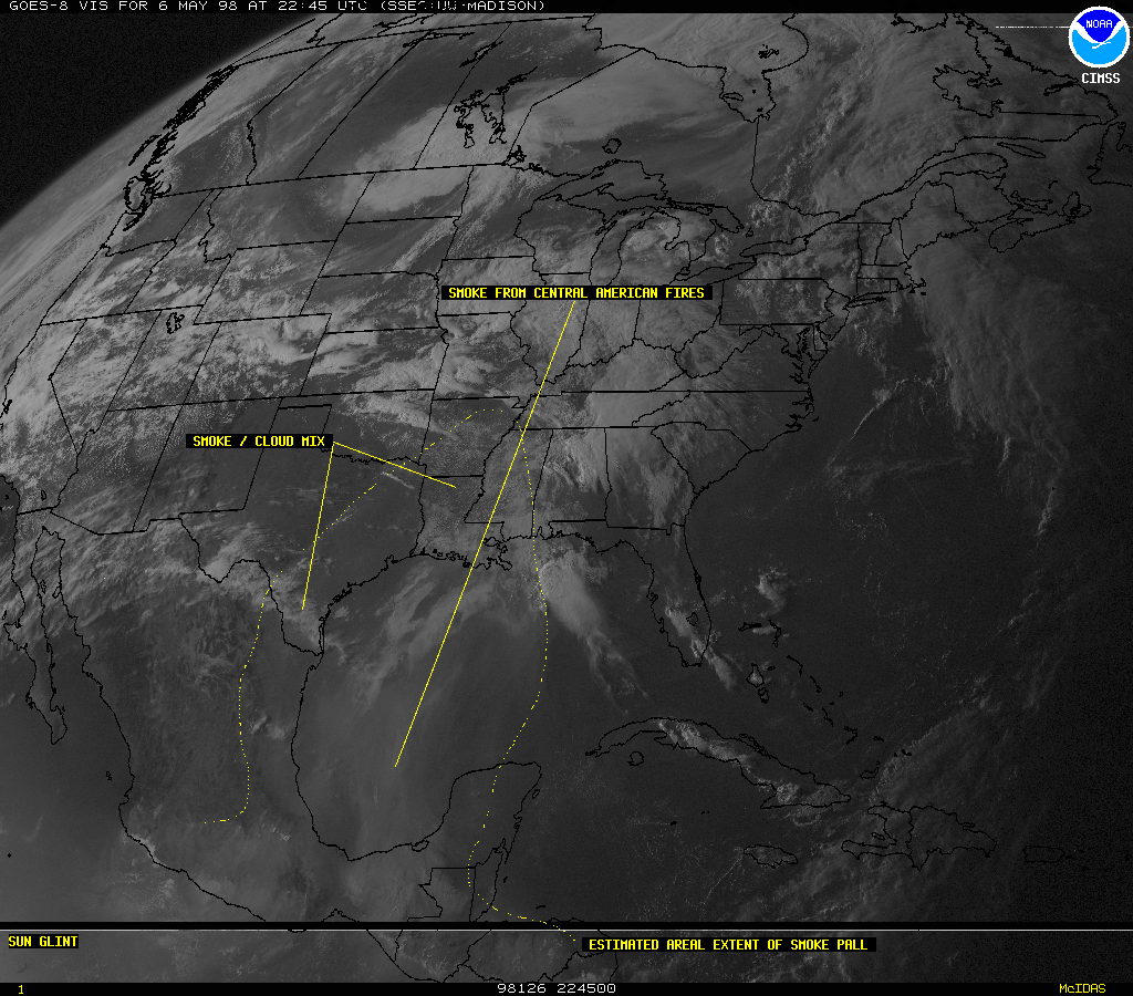
Smoke: Smoke from Central American fires on 6 May 1998, 2245 UTC. More information on atmospheric smoke detection.
Blowing Dust: Northern Mexico and southwest US on 21 January 1999. Visible and Infrared. More information on this event.
Blowing Snow: Iowa on 21 December 2000. Visible and Infrared. More information on this event.
Haze: Haze and US smog drifting over Atlantic Ocean on 8 June 1999, 1945 UTC.
Volcanic Ash Clouds: Soufriere Hills, Montserrat on 21 October 1997. More information on volcanic ash detection and this event.
Snow: Lake effect snow band on 11 January 1999, 1745 UTC. Movie: View a Java animation of this event.
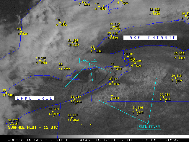
Ice: Ice on Lake Erie on 12 February 2003, 1445 UTC. More information on ice detection.


Atmosphere (top)
Fog: Northeastern United States, river valley fog on 20 September 1994. Visible image.
Fog: Midwestern United States on 8 February 2000, 1445 UTC.
Dryline: Dryline over Texas on 20 May 1999, 2145 UTC. Visible and Infrared. More information on this event.
(Movie) Severe storms: Tornadic event in Texas on 5 May 2002. More information on this event.
Severe Storms: "Enhanced V" over Nebraska on 21 May 1998. More information on this event.
Severe Storms: Tornadic event in South Dakota on 31 May 1998, 0132 UTC.
Hurricanes: Hurricane Mitch, 26 October 1998, 1745 UTC. More information about GOES-8 and this event.
Hurricanes: Hurricane Isabel, 12 September 2003, 1815 UTC. Visible and Montage.
Hurricanes: Colorized image of Hurricane Fran, 4 September 1996, 1715 UTC. More information and imagery on this event.
Hurricanes: Colorized image of Hurricane Opal, 10 October 1995.
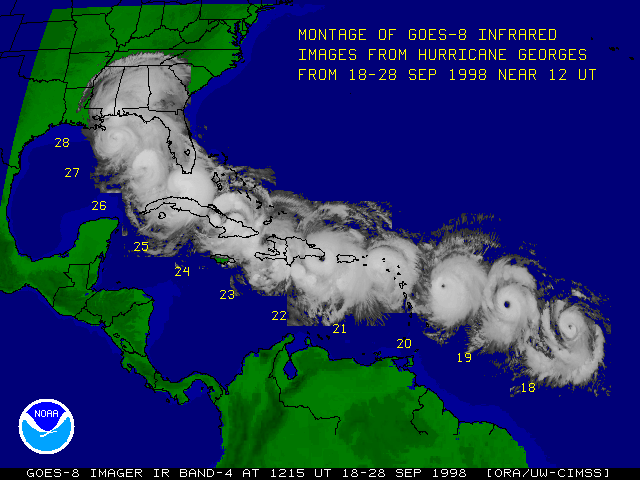
Hurricanes: Montage of Hurricane Georges. 18-28 September 1998. More information on this event.
Hurricanes: "Parade of Storms." 24 August 1995, 1445 UTC.


Global Images (top)
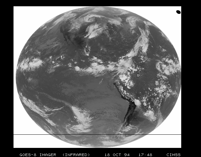
Full Disk: Earth from GOES-8 (RGB) on 2 September 1994, 1800 UTC. Similar images.
Global: GOES-8 as part of the Global Observing System on 1 April 2003, 0600 UTC. Infrared composite.


Derived Products (top)
Sounder Atmospheric Stability: Lifted index: Movie.
Sounder Atmospheric Stability: Lifted index over eastern United States on 25 June 1998, 2346 UTC.
Winds: Sounder-derived winds over the United States. Click for Real-Time Wind page.
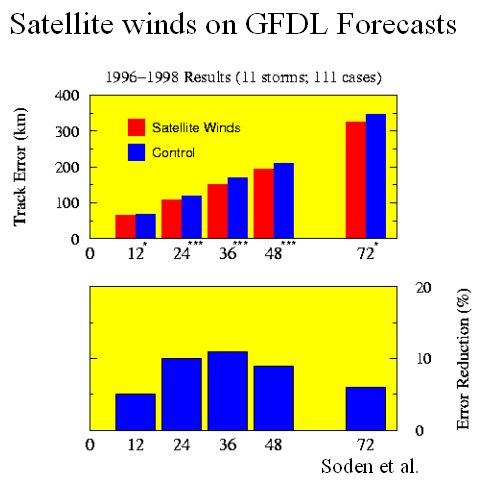
Winds: Effect of satellite-derived winds on GFDL forecasts.
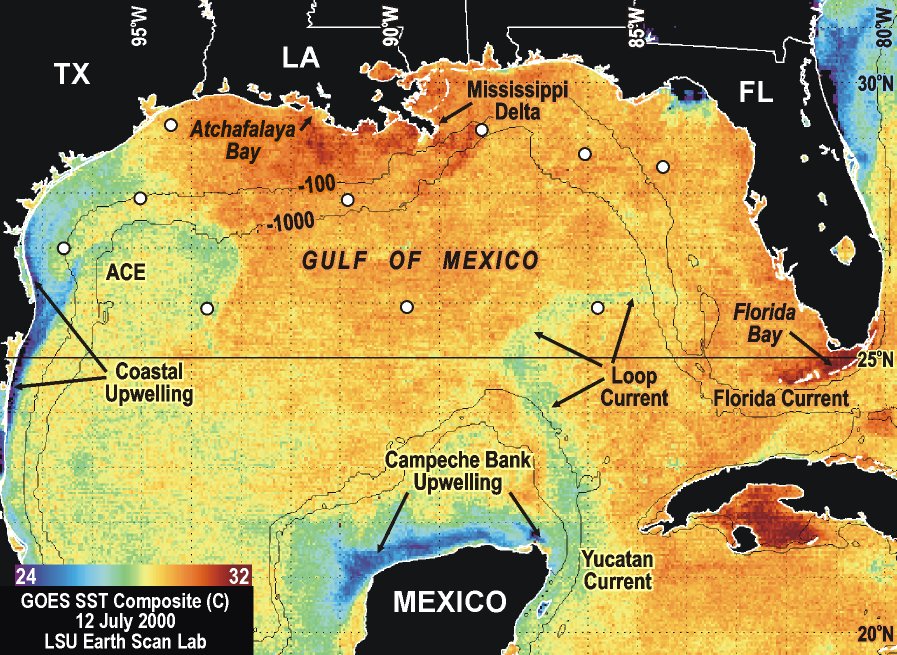
Sea Surface Temperature: SST Composite in Gulf of Mexico on 12 July 2000.
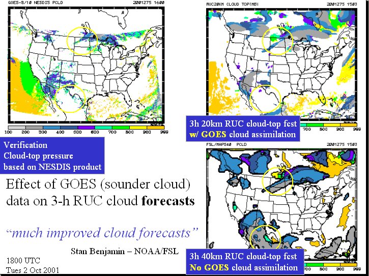
Clouds: Effect of sounder-derived clouds on RUC forecasts.
Ozone: Retrieved ozone product on 8 June 2002, 2300 UTC. More information on retrieved ozone and GOES-8.
Ozone: Total Column Ozone product on 29 September 1999, 1200 UTC. More information on total ozone.


Land Surface (top)
Land Surface Temperature (derived): 6 May 1997, 2230 ETD. More information on Land Surface Temperature.
Heat Islands: Atlanta on 23 August 1995, 1401 UTC. More information on remote sensing of Heat Islands.
Heat Islands: Heat islands in the infrared over the eastern United States on 5 July 1999, 2045 UTC.
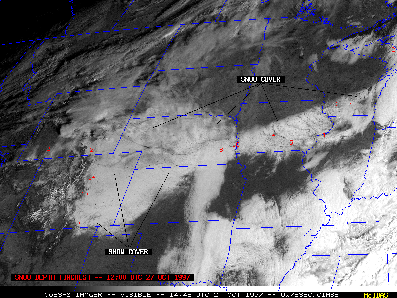
Snow Cover: 24-26 October 1997 winter storm. Visible, Movie, and more information on snow cover and low cloud detection.
Snow Cover: Mid-Atlantic snow on 4 January 2002, 1645 UTC.


Space Environment Monitor (top)
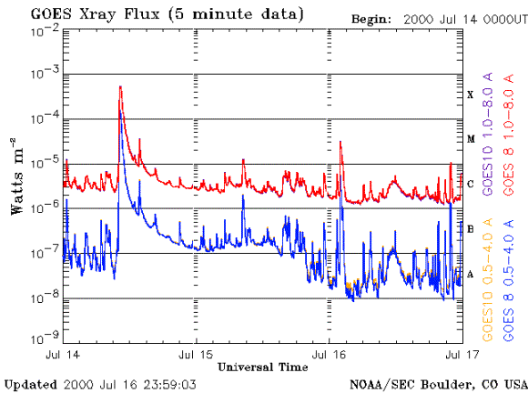
Solar X-Ray Sensor: 16 July 2000, 2359 UTC. More information on the XRS.
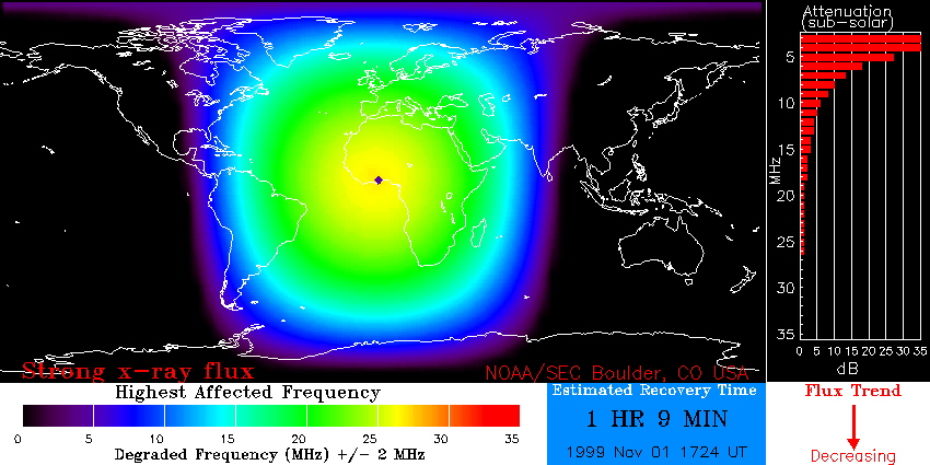
Solar X-Ray Flux: 1 November 1999. Location on the Earth where solar x-rays are affecting the ionosphere (D-Region). It also indicates the radio frequencies affected and the estimated time until conditions return to normal. These high-frequency radio transmissions are used for ground-to-ground and ground-to-air communications by airlines and the military. More about the D-Region Absorption Product.
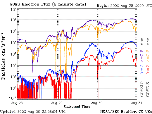
Energetic Particle Sensor: 16 July and 30 August 2000, 2359 UTC. Proton Flux, Electron Flux. More information on the EPS.
Magnetometer: 24 November 2001, 2359 UTC. More information on the Magnetometer.


Data Collection System (top)
Data Collection System: More information on GOES-8 data collection.

Search and Rescue (top)
Search and Rescue: More information on search and rescue with GOES-8.

Miscellaneous (top)
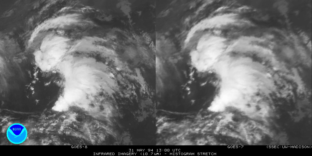
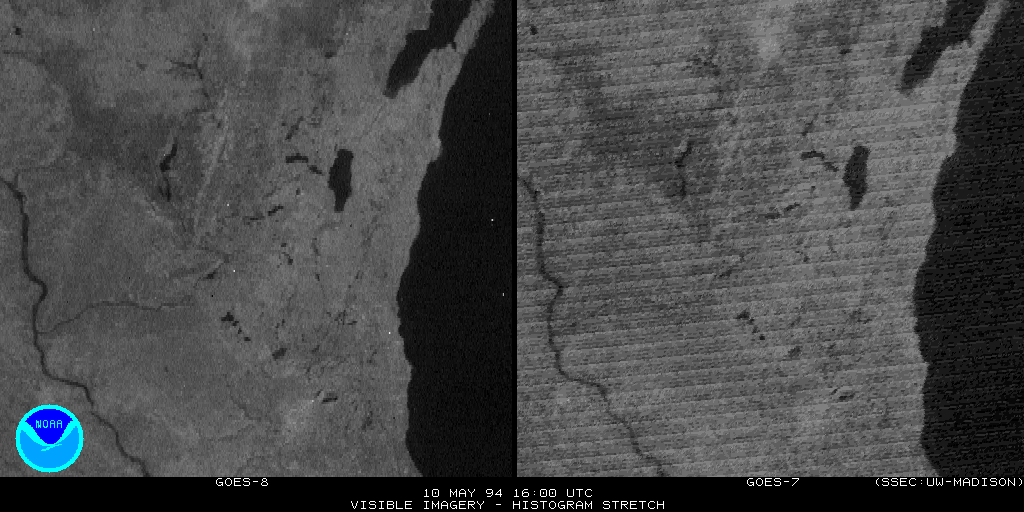
GOES-8 vs. GOES-7: Visible, Infrared comparisons.
Shuttle Launches: STS-71 (Atlantis) on 27 June 1995, 1934 UTC. More information on observing shuttle launches.
The Moon: Captured by GOES-8 in the Visible and full-disk Infrared.
Solar Eclipse: 10 May 1994, 1633 GMT.


Select References (top)
101 referred journal articles that deal with GOES-8. The topics are varied and include (but not limited to): calibration, navigation, derived products, fire detection and characterization, satellite-derived winds, numerical modeling, radiation, weather forecasting, SST, severe storms, retrievals, dust, hurricanes, solar environment, clouds, volcanoes, aircraft dissipation trails, clouds, ozone, precipitation, land temperatures and fog.
Related Links (top)
Thank you GOES-8 for almost 8 years of operational service -- June 9, 1995 to April 1, 2003! Thanks also to all those who helped design, research, build, test, operate and implement both the GOES-8 instruments and products. GOES-8 gave a clearer picture of the atmosphere, land, ocean and space.
Acknowledgements: Kris Karnauskas, Tim Schmit