Strong jet streak over the Lower 48 states
The 250-hPa jet streak currently over the CONUS contains wind speeds approaching 200 kt (230 mph) and is assoc. w/ standardized anomalies >3? spanning from Texas to Michigan. I suspect this jet streak is also helping cross-country flights arrive early on the East Coast! ? ? pic.twitter.com/z7474e6bXk
— Alicia M Bentley (@AliciaMBentley) February 17, 2019
![GOES-16 Upper-level Water Vapor (6.2 µm) images, with plots of Derived Motion Winds [click to play animation | MP4]](https://cimss.ssec.wisc.edu/satellite-blog/wp-content/uploads/sites/5/2019/02/190217_goes16_waterVapor_derivedMotionWinds_anim.gif)
GOES-16 Upper-level Water Vapor (6.2 µm) images, with plots of Derived Motion Winds [click to play animation | MP4]
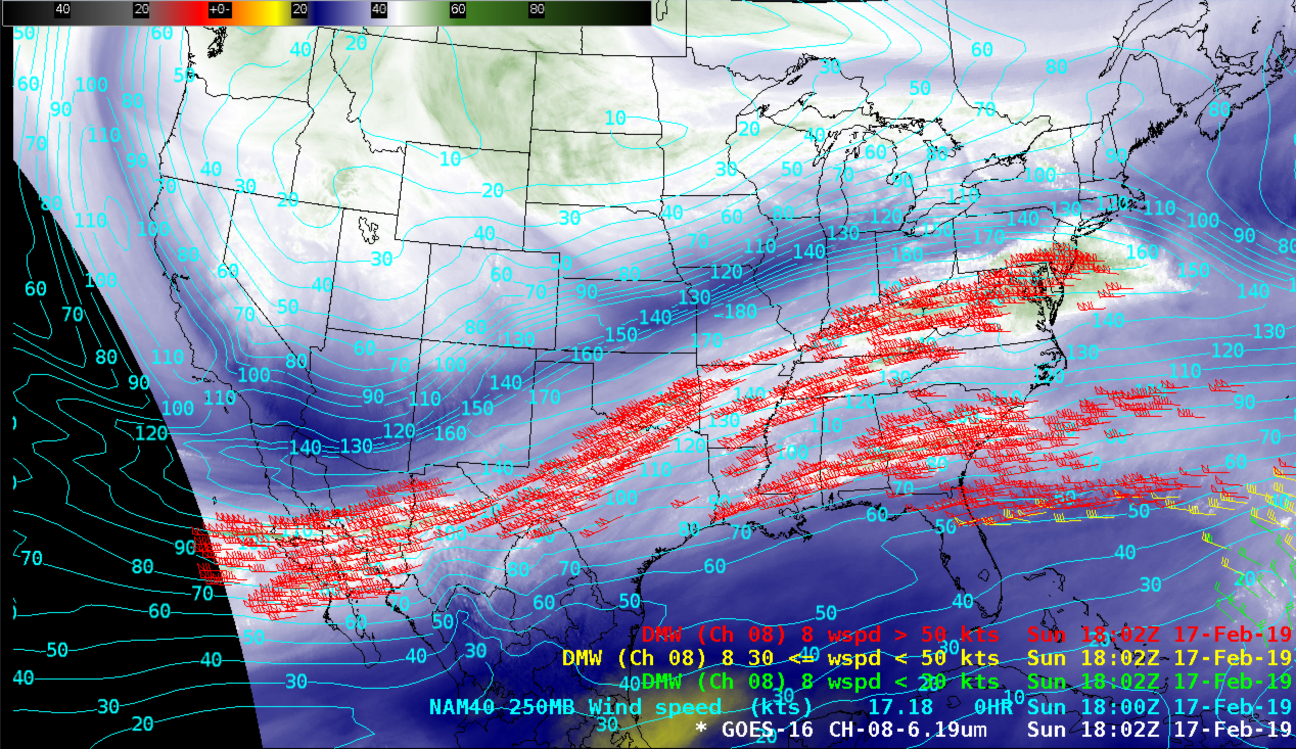
![GOES-16 Upper-level Water Vapor (6.2 µm) image, with plots of Derived Motion Winds at 0002 UTC [click to enlarge]](https://cimss.ssec.wisc.edu/satellite-blog/wp-content/uploads/sites/5/2019/02/190218_0002utc_wvwinds_181kts.png)
GOES-16 Upper-level Water Vapor (6.2 µm) image, with plots of Derived Motion Winds at 0002 UTC [click to enlarge]
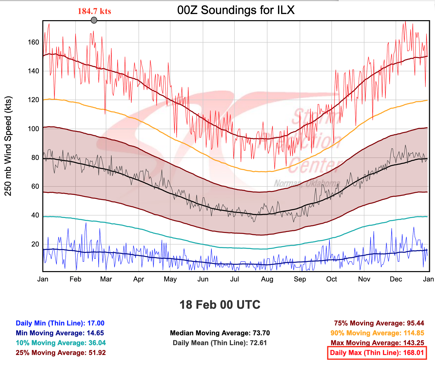
![Plot of 00 UTC rawinsonde data from Lincoln, Illinois [click to enlarge]](https://cimss.ssec.wisc.edu/satellite-blog/wp-content/uploads/sites/5/2019/02/190218_00utc_kilx_raob.png)
Plot of 00 UTC rawinsonde data from Lincoln, Illinois [click to enlarge]
![GOES-16 Air Mass RGB images [click to play animation | MP4]](https://cimss.ssec.wisc.edu/satellite-blog/wp-content/uploads/sites/5/2019/02/190217_goes16_airmassRGB_anim.gif)
GOES-16 Air Mass RGB images [click to play animation | MP4]
===== 18 February Update =====
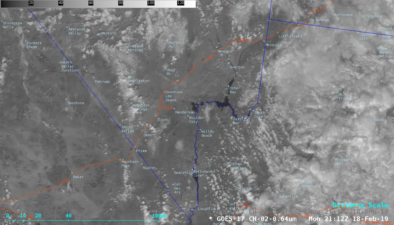
![GOES-17 "Red" Visible (0.64 µm) and Near-Infrared "Snow/Ice (1.61 µm) images [click to play animation | MP4]](https://cimss.ssec.wisc.edu/satellite-blog/wp-content/uploads/sites/5/2019/02/190218_goes17_visible_snowIce_Las_Vegas_NV_anim.gif)
GOES-17 “Red” Visible (0.64 µm) and Near-Infrared “Snow/Ice (1.61 µm) images [click to play animation | MP4]
The snow cover was apparent in Visible imagery from 4 GOES (below) — GOES-17 (GOES-West), GOES-15 (the backup GOES-West), GOES-16 (GOES-East) and GOES-13 (the backup GOES-East, which had been brought out of storage for annual maintenance activities).
![Visible images from GOES-17, GOES-15, GOES-15 and GOES-13 [click to play animation | MP4]](https://cimss.ssec.wisc.edu/satellite-blog/wp-content/uploads/sites/5/2019/02/190218_goes17_goes15_goes16_goes13_Las_Vegas_NV_anim.gif)
Visible images from GOES-17, GOES-15, GOES-15 and GOES-13 [click to play animation | MP4]
? Lots of chatter this morning about the snow in #Vegas! Here’s a look at some of the observed totals, with most of the accumulations favoring the southern and western edges of town. #VegasWeather ? pic.twitter.com/oo6UHwJUix
— NWS Las Vegas (@NWSVegas) February 18, 2019