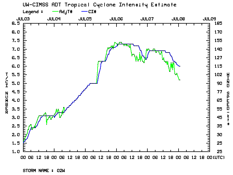
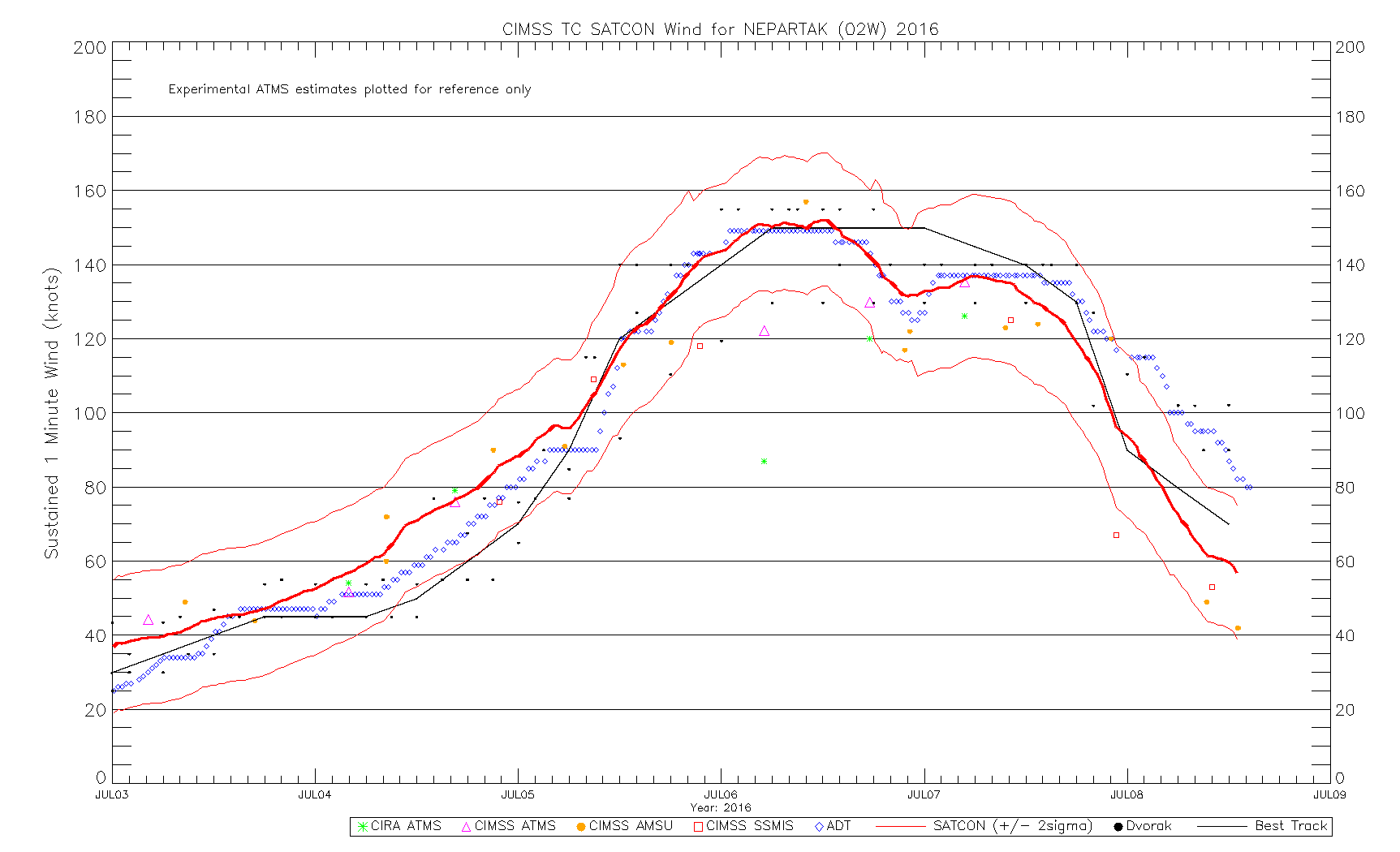
Super Typhoon Nepartak
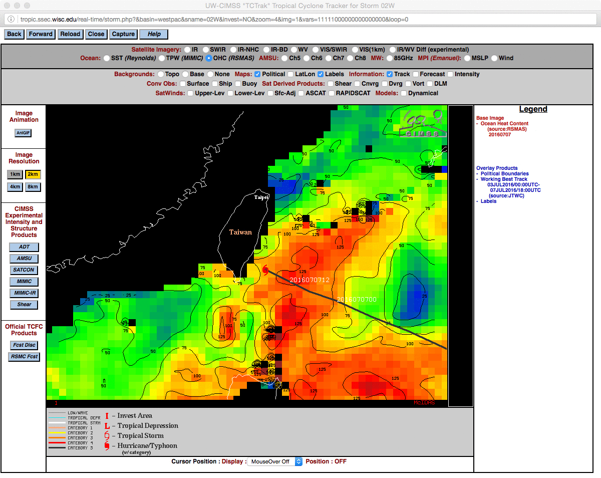
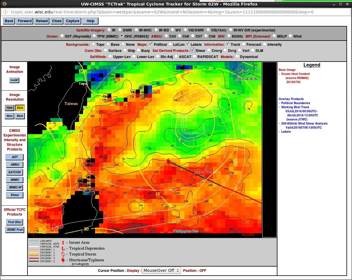
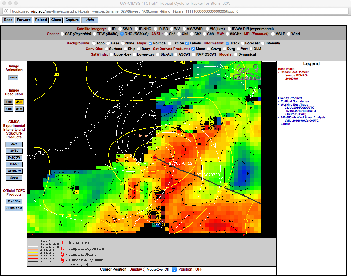
![Track of Super Typhoon Nepartak (03 to 07 July 2016) [click to enlarge]](https://cimss.ssec.wisc.edu/satellite-blog/wp-content/uploads/sites/5/2016/07/160703-07_Super_Typhoon_Nepartak_track.jpg)
Track of Super Typhoon Nepartak (03 to 07 July 2016) [click to enlarge]
![Himawari-8 Visible (0.64 µm) images [click to play MP4 animation]](https://cimss.ssec.wisc.edu/satellite-blog/wp-content/uploads/sites/5/2016/07/NEPARTAK_VIS_DEFAULT_960x1280_B3_00060_2016189_022940_0001PANEL.GIF)
Himawari-8 Visible (0.64 µm) images [click to play MP4 animation]
![Himawari-8 Infrared Window (10.4 µm) images [click to play MP4 animation]](https://cimss.ssec.wisc.edu/satellite-blog/wp-content/uploads/sites/5/2016/07/960x1280_H8F_B13_HIM08_IR_NEPARTAK_07JUL2016_2016189_050715_0001PANEL.GIF)
Himawari-8 Infrared Window (10.4 µm) images [click to play MP4 animation]
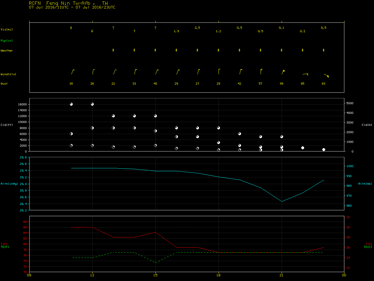
If you missed it: my pressure trace from #Typhoon #NEPARTAK, using @KestrelWeather Meter. Eye passed just S of city. pic.twitter.com/qqUVNBbyBK
— Josh Morgerman (@iCyclone) July 10, 2016
Shortly before landfall, a comparison of DMSP-18 SSMIS Microwave (85 GHz) and Himawari-8 Infrared Window (10.4 µm) images around 20 UTC (below) showed that the eye was still rather distinct on the microwave image.
![DMSP-16 SSMIS Microwave (85 GHz) and Himawari-8 Infrared Window (10.4 µm) images [click to enlarge]](https://cimss.ssec.wisc.edu/satellite-blog/wp-content/uploads/sites/5/2016/07/160707_20utc_dmsp16_ssmis_microwave_himawari8_infrared_anim.gif)
DMSP-16 SSMIS Microwave (85 GHz) and Himawari-8 Infrared Window (10.4 µm) images [click to enlarge]
![MIMIC-TC product [click to enlarge]](https://cimss.ssec.wisc.edu/satellite-blog/wp-content/uploads/sites/5/2016/07/160707-08_mimic_Nepartak_landfall_anim.gif)
MIMIC-TC product [click to enlarge]
![Himawari-8 0.64 µm Visible (top) and 10.4 µm Infrared Window (bottom) images [click to play MP4 animation]](https://cimss.ssec.wisc.edu/satellite-blog/wp-content/uploads/sites/5/2016/07/480x1280_H8F_B313_HIM08_VIS_IR_NEPARTAK_06-07JUL2016_2016189_044715_0002PANELS.GIF)
Himawari-8 0.64 µm Visible (top) and 10.4 µm Infrared Window (bottom) images [click to play MP4 animation]
![Suomi NPP VIIRS true-color image on 07 July [click to enlarge]](https://cimss.ssec.wisc.edu/satellite-blog/wp-content/uploads/sites/5/2016/07/160707_1445utc_suomi_npp_viirs_truecolor_metar_Nepartak_map_only_anim.gif)
Suomi NPP VIIRS true-color image on 07 July [click to enlarge]
![Himawari-8 Infrared Window (10.4 µm) images [click to play MP4 animation]](https://cimss.ssec.wisc.edu/satellite-blog/wp-content/uploads/sites/5/2016/07/960x1280_H8F_B13_HIM08_IR_NEPARTAK_06JUL2016_2016188_151945_0001PANEL.GIF)
Himawari-8 Infrared Window (10.4 µm) images [click to play MP4 animation]
![Suomi NPP VIIRS Infrared Window (11.45 µm) and Day/Night Band (0.7 µm) images [click to enlarge]](https://cimss.ssec.wisc.edu/satellite-blog/wp-content/uploads/sites/5/2016/07/160706_1729utc_suomi_npp_viirs_infrared_day_night_band_STY_Nepartak_anim.gif)
Suomi NPP VIIRS Infrared Window (11.45 µm) and Day/Night Band (0.7 µm) images [click to enlarge]
![MIMIC-TC product [click to enlarge]](https://cimss.ssec.wisc.edu/satellite-blog/wp-content/uploads/sites/5/2016/07/160706_mimic_Nepartak_ERC_anim.gif)
MIMIC-TC product [click to enlarge]