This website works best with a newer web browser such as Chrome, Firefox, Safari or Microsoft Edge. Internet Explorer is not supported by this website.

Upwelling of cool water in Lake Michigan

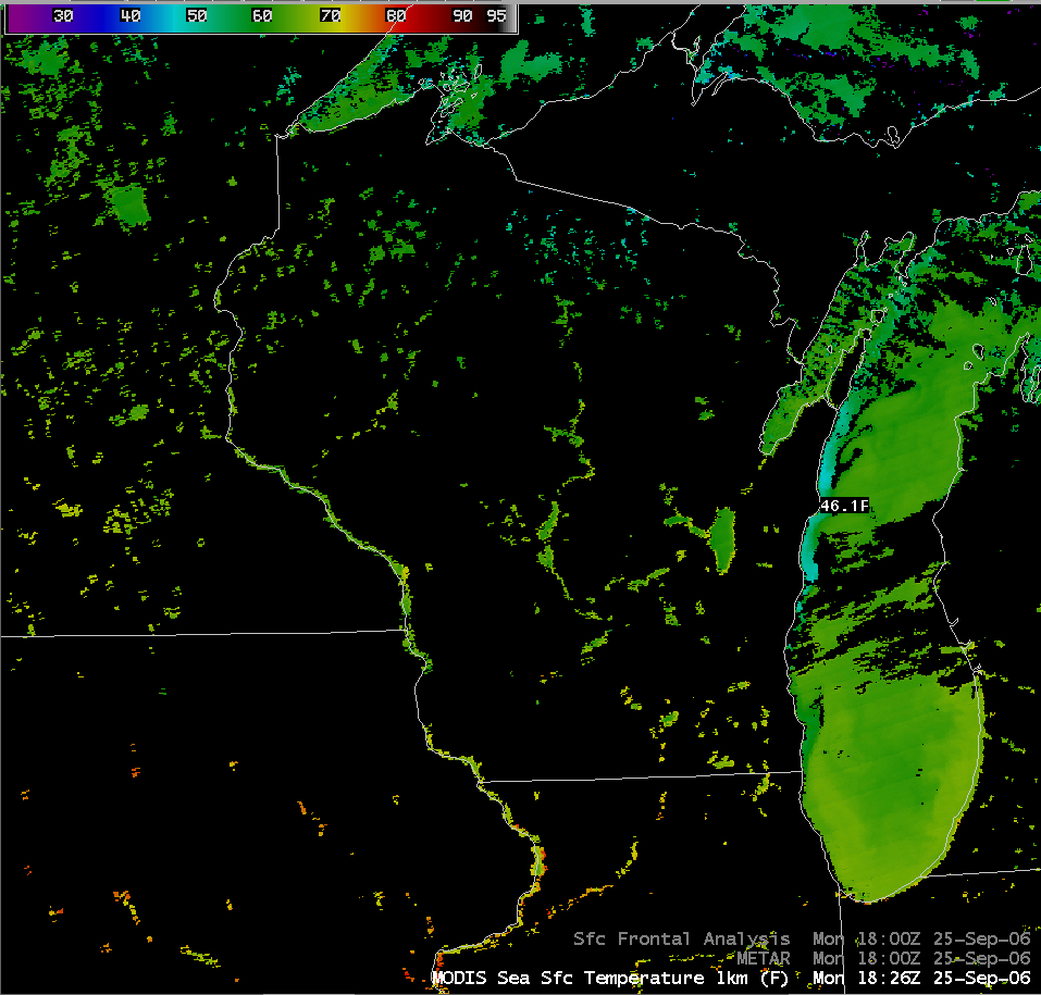
Westerly winds during the past 2 days (in the wake of a cold frontal passage) have helped to intensify the upwelling of cooler water along the Wisconsin shore of Lake Michigan. The 1-km resolution AWIPS MODIS... Read More

AWIPS MODIS Sea Surface Temperature

Westerly winds during the past 2 days (in the wake of a cold frontal passage) have helped to intensify the upwelling of cooler water along the Wisconsin shore of Lake Michigan. The 1-km resolution AWIPS MODIS Sea Surface Temperature product (above) indicated water as cold as 46.1 F (7.8 C) near Sheboygan, Wisconsin (compared to water temperatures of 60-65 F [15-18 C] in central portions of Lake Michigan). This upwelling was also evident on the 4-km resolution GOES-12 10.7 µm IR channel data, which showed brightness temperatures as cold as 46.4 F (8 C) in that same region. Areas of upwelling bring cooler, nutrient-rich water to the surface, which enhances the growth of photosynthetic algae (as seen by the blue-green hues in the corresponding MODIS true color image).

And while we’re on the topic of cold water…check out the evolution of the intricate structure of the marine layer stratocumulus clouds over the California Current (large-scale animation | close-up animation)!

View only this post Read Less

MODIS true color: snow cover, and autumn color

Signs of the Autumn season show up nicely on MODIS true color imagery (above): snow cover is gradually becoming established in parts of the northern and central Rocky Mountains, as well as the northern Black Hills of South Dakota (close-up MODIS images centered at Read More

MODIS true color image

Signs of the Autumn season show up nicely on MODIS true color imagery (above): snow cover is gradually becoming established in parts of the northern and central Rocky Mountains, as well as the northern Black Hills of South Dakota (close-up MODIS images centered at Denver, Colorado and Rapid City, South Dakota) — the snow cover is confirmed by the dark red enhancement in the MODIS false color image (below), which uses the near-IR Band 7 to detect a strong ice signal. In addition, the amber hues of Fall tree color are beginning to increase across the UP of Michigan (photo) into north-central Wisconsin (close-up MODIS image of Wisconsin). The amber colors of the vegetation across much of northeastern Iowa and southeastern Minnesota are due to harvested corn and wheat fields that are now dormant.
MODIS false color image

View only this post Read Less

Severe convection at 1-minute intervals

A 200-image animation (29 MB QuickTime movie, above) of Super Rapid Scan Operations (SRSO) GOES-10 visible channel imagery shows the development of supercell thunderstorms at 1-minute intervals across northern Arkansas and southern Missouri between 17:00 and 22:07 UTC (12:00 Noon and 5:07 PM local time) on Read More

GOES-10 visible animation
A 200-image animation (29 MB QuickTime movie, above) of Super Rapid Scan Operations (SRSO) GOES-10 visible channel imagery shows the development of supercell thunderstorms at 1-minute intervals across northern Arkansas and southern Missouri between 17:00 and 22:07 UTC (12:00 Noon and 5:07 PM local time) on 22 September. During that time period, this particular convection produced softball-size hail (4.25 inches in diameter) and multiple tornadoes across southern Missouri (including one producing F4 damage near Crosstown), and 3.0 inch diameter hail in northern Arkansas (SPC storm reports). Heavy rainfall and flash flooding was also reported, with 10.16 inches of rain falling at Myrtle, Missouri (near the Missouri/Arkansas border). Additional details on these storms are available from the St. Louis MO and Springfield MO NWS offices.
.
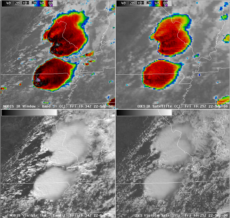
An AWIPS MODIS/GOES comparison of the InfraRed (IR) and visible channel images around 19:30 UTC (below) shows well-defined enhanced-v signatures on the IR “window channel” imagery. At that time, the IR cloud top temperatures in the vicinity of the overshooting tops over northern Arkansas were as cold as -86 C on the 1-km resolution MODIS IR data, versus -68 C on the 4-km resolution GOES IR data. A 100-image QuickTime animation of the GOES-10 IR window channel imagery shows the evolution of the various enhanced-v signatures during the 17:45-20:19 UTC time period (12:45-3:19 PM local time).
AWIPS MODIS/GOES IR and visible comparison

View only this post Read Less

An occluding cyclone (at 1 minute intervals)

A deepening mid-latitude cyclone (located over southeastern Colorado / southwestern Kansas at 12 UTC) began to transition from the mature stage to the occluded stage during the morning hours on 21 September. The tell-tale occluding cyclone signature... Read More

GOES-10 water vapor image

A deepening mid-latitude cyclone (located over southeastern Colorado / southwestern Kansas at 12 UTC) began to transition from the mature stage to the occluded stage during the morning hours on 21 September. The tell-tale occluding cyclone signature (consisting of a wrapping “dry slot swirl”) was depicted on the 8-km resolution GOES-10 6.7 micrometer “water vapor channel” imagery (above) — a 200-image QuickTime animation shows the evolution of the occlusion process at 1-minute intervals, since the GOES-10 satellite was still in Super Rapid Scan Operations (SRSO) mode. By 15 UTC, HPC analyzed the feature as an occluded low; later that afternoon several tornadoes were reported in northcentral Kansas as the low moved over that region.

.
Additional structure is revealed on the 1-km resolution MODIS water vapor imagery at 17 UTC. Also, strong winds were causing a plume of blowing dust along the advancing cold frontal boundary — this dust plume exhibits a signal (yellow to orange enhancement) on the MODIS 11-12 micrometer IR difference product (below). Note the observation of blowing dust at Lubbock, Texas (station identifier LBB in the lower left corner of the image), where westerly surface winds were 38 mph (gusting to 47 mph); the blowing dust was reducing visibility to 3 miles at that particular time.
MODIS IR difference product

View only this post Read Less