This website works best with a newer web browser such as Chrome, Firefox, Safari or Microsoft Edge. Internet Explorer is not supported by this website.

Upper Midwest ice storm

A freezing drizzle / light freezing rain event occurred across parts of the Upper Midwest on 03 January04 January 2009 — an ice accrual of 0.1 to 0.2 inch was reported at... Read More

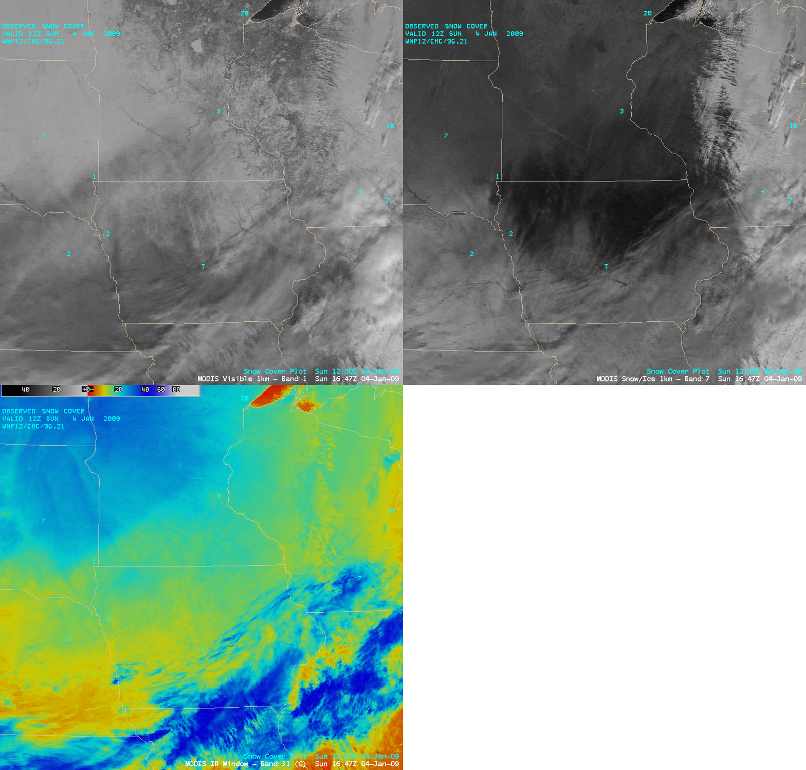
MODIS visible, snow/ice, and IR window channel images

MODIS visible, snow/ice, and IR window channel images

A freezing drizzle / light freezing rain event occurred across parts of the Upper Midwest on 03 January04 January 2009 — an ice accrual of 0.1 to 0.2 inch was reported at some locations in northern Iowa, southern Minnesota, and southern Wisconsin. Post-event AWIPS images of the 1-km resolution MODIS visible channel, the 2.1 µm  “snow/ice” channel, and the 11.0 µm “IR window” channel (above) demonstrated the utility of using the snow/ice channel imagery to depict the areal coverage of significant ice accrual. Snow (and especially ice) are strong absorbers at the near-IR 2.1 µm wavelength, so those show up as much darker features on the MODIS snow/ice image (in contrast to supercooled water droplet clouds, which show up as much brighter features).

A mixture of low and high clouds covered  the southern, southeastern, and eastern portions of satellite images shown above — but most of the MODIS image scene on 04 January was cloud-free snow cover. Even though there was generally more snow cover in place across the northern half of the image area (from eastern South Dakota to northern Minnesota), the ice-glazed snow pack farther to the south across norther Iowa and southern Minnesota appeared even darker on the snow/ice image.

The National Weather Service forecast office at Milwaukee/Sullivan, Wisconsin posted an excellent  discussion of the classic thermal profile for ice for this particular event.

— 05 JANUARY UPDATE —

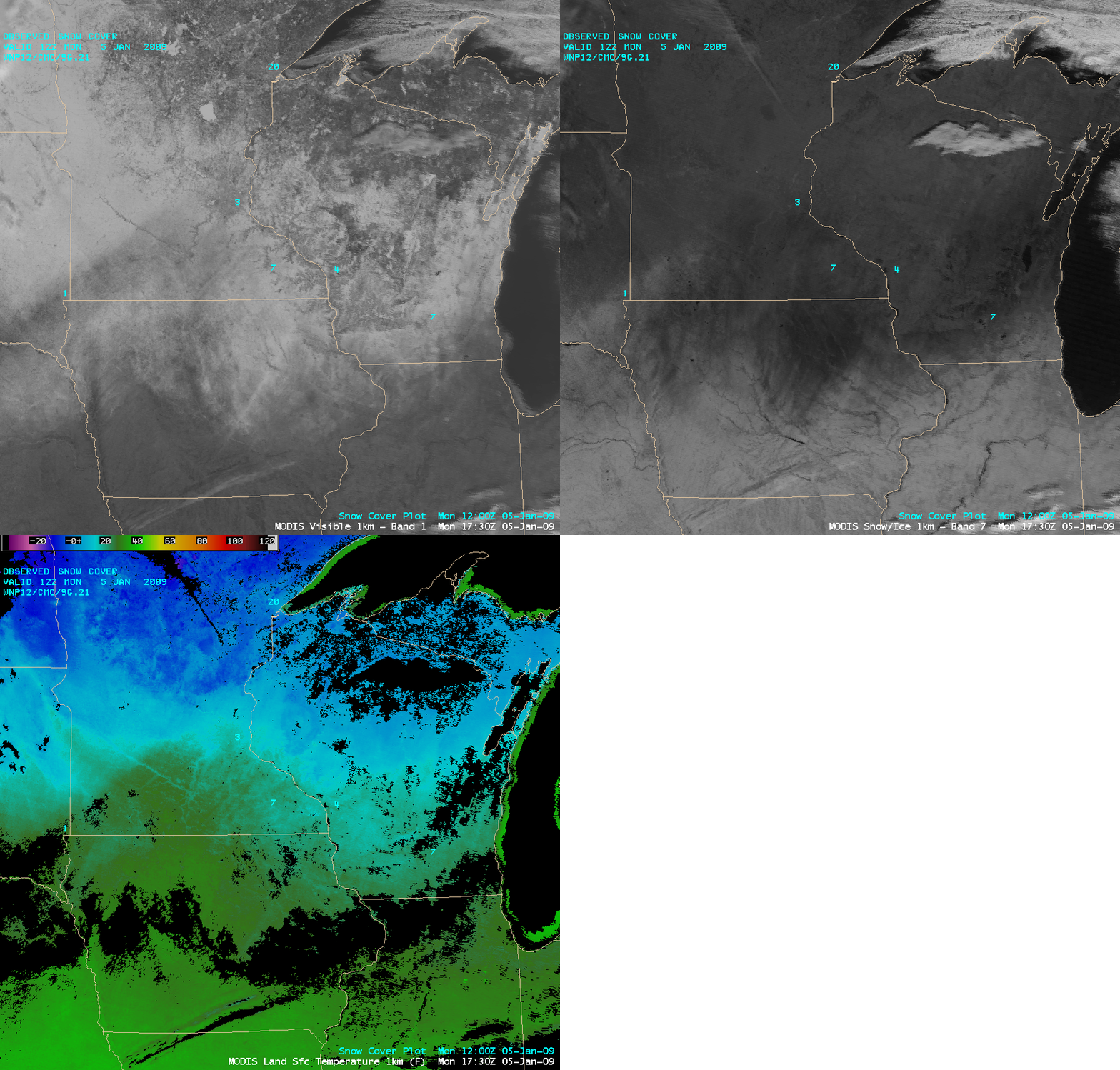
On the following day (05 January), conditions were relatively cloud-free over most of the region, allowing a view of the ice accrual farther to the east across southern Wisconsin (below). The western half of the darker “ice accrual signal” over western Iowa seemed to be diminishing, due to full sunshine and brisk southwesterly winds helping to erode the thickness of the surface ice glaze somewhat. MODIS Land Surface Temperatures were in the upper 20s to around 30 F (darker green colors) across the ice-covered areas of northern Iowa at 17:30 UTC (11:30 am local time).

MODIS visible, 2.1 µm snow/ice, and Land Surface Temperature images

MODIS visible, 2.1 µm snow/ice, and Land Surface Temperature images

View only this post Read Less

Advection fog in Oklahoma

AWIPS images of the GOES-13 fog/stratus product (above) showed a plume of advection fog curling northwestward across southern Oklahoma on 02 January 2009. A relatively moist low-level air mass with dew points in the 40s F was flowing from northeastern Texas into southeastern Oklahoma (where radiational cooling was allowing surface air temperatures... Read More

GOES-13 fog/stratus product

GOES-13 fog/stratus product

AWIPS images of the GOES-13 fog/stratus product (above) showed a plume of advection fog curling northwestward across southern Oklahoma on 02 January 2009. A relatively moist low-level air mass with dew points in the 40s F was flowing from northeastern Texas into southeastern Oklahoma (where radiational cooling was allowing surface air temperatures to drop into the upper 30s F). Once the fog moved in, the surface visibility was restricted to 1/4 mile at Ardmore (station identifier KADM) and Stillwater (station identifier KSWO) in Oklahoma.

GOES-13 fog/atratus product + NAM surface winds

GOES-13 fog/stratus product + NAM surface winds

A sequence of GOES-13 fog/stratus product images with an overlay of the surface frontal analysis and the NAM20 surface winds (above) indicated that there was a weak surface low located over northern Texas, which was helping to feed the moisture across the decaying stationary frontal boundary and into Oklahoma.

GOES-13 sounder Cloud Top Height product

GOES-13 sounder Cloud Top Height product

Images of the GOES-13 sounder Cloud Top Height product (above) indicated that the cloud tops were generally in the 7500-8000 foot range (yellow to light green colors) across southeastern Oklahoma.

View only this post Read Less
MTSAT High Density Winds

Beginning in October 2008,  “high density winds” (also known as Atmospheric Motion Vectors, or AMVs) derived from the Japanese geostationary  Multi-functional Transport Satellite (MTSAT-1R, which is positioned over the Equator at 140º East longitude) were added to the NOAAPORT Satellite Broadcast Network (SBN). National Weather Service... Read More

MTSAT High Density Winds (AWIPS menu)

MTSAT High Density Winds (AWIPS menu)

Beginning in October 2008,  “high density winds” (also known as Atmospheric Motion Vectors, or AMVs) derived from the Japanese geostationary  Multi-functional Transport Satellite (MTSAT-1R, which is positioned over the Equator at 140º East longitude) were added to the NOAAPORT Satellite Broadcast Network (SBN). National Weather Service forecast offices localized as West CONUS sites (or OCONUS offices in the Alaska Region and the Pacific Region) that have installed AWIPS Operational Build 9.0 or higher will be able to access these new MTSAT satellite winds products from the AWIPS menu (above).
TECHNICAL IMPLEMENTATION NOTICE 08-61
NATIONAL WEATHER SERVICE HEADQUARTERS WASHINGTON DC
317 PM EDT FRI AUG 1 2008 

SUBJECT:  NESDIS HIGH DENSITY GEOSTATIONARY WINDS TO BE
          ADDED TO SBN/NOAAPORT: EFFECTIVE OCTOBER 15 2008 

EFFECTIVE WEDNESDAY OCTOBER 15 2008...BEGINNING AT APPROXIMATELY
1500 COORDINATED UNIVERSAL TIME /UTC/...THE NATIONAL
ENVIRONMENTAL SATELLITE...DATA...AND INFORMATION SERVICE /NESDIS/
AND NWS START DISSEMINATING HIGH DENSITY GEOSTATIONARY /MTSAT/
WIND PRODUCTS VIA SBN/NOAAPORT.

THE MTSAT WINDS /FROM THE JAPANESE SATELLITE/ WILL AUGMENT THE
CURRENT GOES EAST AND WEST HIGH DENSITY WINDS OVER SPARSE DATA
REGIONS...MOST BENEFITING THE ALASKA AND PACIFIC REGIONS AND THE
AVIATION WEATHER CENTER /AWC/.
Coverage of MTSAT vs GOES High Density Winds

Coverage of MTSAT High Density Winds vs GOES High Density Winds

A comparison of the areal coverage of the MTSAT vs the GOES high density winds is shown on the Pacific Mercator scale  (above) and Northern Hemisphere scale (below). The MTSAT high density winds will be available north of the Equator every 3 hours (at 02, 05, 08, 11, 14, 17, 20, and 23 UTC), and south of the Equator every 6 hours (at 00, 06, 12, and 18 UTC).

Coverage of MTSAT vs GOES High Density Winds

Coverage of MTSAT High Density Winds vs GOES High Density Winds

With the AWIPS cursor sampling function activated, the user will be able to display the valid time, the type of satellite imagery used to derive a particular AMV (Visible, InfraRed, shortwave InfraRed, or Water Vapor), the pressure of the height assignment for that AMV, and the direction/speed of that AMV (below). The wind vectors can be color-coded according to pressure layers (as shown below), or by AMV type (IR, Water Vapor, Visible, or 3.9 µm shortwave IR). Targets are tracked on three consecutive satellite images in order to calculate the direction and speed of each AMV.

MTSAT High Density Winds

MTSAT High Density Winds

These MTSAT winds available on AWIPS should be very similar to those derived using GOES data, since NESDIS is using the same AMV software (which was developed at CIMSS) for both satellites. For more details about the derivation and application of satellite-derived atmospheric motion vector products, see the SHyMet GOES High Density Winds lesson.

Reference:

Velden, C.S. et al., 2005: Recent Innovations in Deriving Winds from Meteorological Satellites. Bull. Amer. Meteor. Soc., 86, 205-223

– Updated 29 January 2009

View only this post Read Less
Cold air builds in Alaska

Very cold air was becoming established across the interior of Alaska during the last few days of December 2008. AWIPS images of the 4-km resolution GOES-11 10.7 µm IR channel (above) showed large areas exhibiting very cold IR brightness temperatures (colder than -40º C, darker blue color enhancement) which were... Read More

GOES-11 10.7 µm IR images

GOES-11 10.7 µm IR images

Very cold air was becoming established across the interior of Alaska during the last few days of December 2008. AWIPS images of the 4-km resolution GOES-11 10.7 µm IR channel (above) showed large areas exhibiting very cold IR brightness temperatures (colder than -40º C, darker blue color enhancement) which were increasing in areal coverage as the surface temperatures continued to drop. The coldest air temperature measured in Alaska on 30 December 2008 was -49º C (-57º F) at O’Brien Creek; the temperature at the Fairbanks airport dropped to -41º C (41º F), with the coldest location in the Fairbanks urban corridor (the Woodsmoke subdivision at North Pole) reaching -43º C (-46º F).

A closer look using 1-km resolution 10.8 µm IR data from the AVHRR instrument on the NOAA series of polar-orbiting satellites (below) showed remarkable detail in the cold surface temperatures, whose patterns were strongly influenced by elevation. Due to cold air drainage, the coldest surface IR temperatures (indicated by the darkest blue color enhancement) were found in lower elevations such as river valleys and the Yukon Flats area of interior Alaska — note that the Yukon Flats region (located in the lower right quadrant of the images) exhibited a progressively darker blue enhancement on these 3 IR images as the surface temperatures plummeted during that time period. The coldest IR brightness temperature seen on the 15:57 UTC image was 222º K (-51º C, or -60º F) — and the air temperature at Fort Yukon was -46º C (-51º F) at that particular time.

NOAA-15 / NOAA-17 / NOAA-18 AVHRR 10.8 µm IR images

NOAA-15 / NOAA-17 / NOAA-18 AVHRR 10.8 µm IR images

With such cold temperatures becoming established up in Alaska, parts of the Lower 48 states should be on notice for a possible arctic outbreak in the coming weeks…

— 04 JANUARY 2009 UPDATE —

The coldest temperatures during this particular streak of cold temperatures occurred on 04 January 2009, when -54º C (-65º F) was reported at O’Brien Creek. A NOAA-17 AVHRR 10.8 µm IR image (below) indicated that IR brightness temperatures in the Yukon Flats region (located in the southeastern portion of the image) were as cold as -52º C (-62º F) at 20:51 UTC (11:51 AM local time).

NOAA-17 AVHRR 10.8 µm IR image

NOAA-17 AVHRR 10.8 µm IR image

— 10 January 2009 Update —

The coldest official temperatures recorded in Alaska during this 15-day-long cold spell were -56º C (-68º F) at O’Brien Creek (on 10 January) and at Chicken (on 08 January). In Fairbanks, the temperature remained below -40º C/F for a 24-hour period on 05-06 January.

View only this post Read Less