AWIPS images of 4-km resolution GOES-13 10.7 µm IR channel data (above) showed a large convective complex that developed over extreme eastern Colorado and then tracked eastward across Kansas and Nebraska during the pre-daylight hours on 15 September 2010. According to the... Read More

GOES-13 10.7 µm IR images
AWIPS images of 4-km resolution GOES-13 10.7 µm IR channel data (above) showed a large convective complex that developed over extreme eastern Colorado and then tracked eastward across Kansas and Nebraska during the pre-daylight hours on 15 September 2010. According to the SPC Storm Reports, this severe convection produced a few tornadoes, hail up to 1.75 inch in diameter, and surface winds gusts as high as 78 mph across Kansas.
A comparison of the 1-km resolution POES AVHRR 10.8 µm IR image with the corresponding 4-km resolution GOES-13 10.7 µm IR image (below) demonstrates the improved ability to detect such mesoscale storm top features as overshooting tops and packets of concentric gravity waves. At that particular time, the coldest AVHRR IR brightness temperature was -80º C, compared to -71º C on the GOES-13 IR image. The parallax error associated with geostationary satellite imagery was also apparent, with the slight northwestward shift of the location of the features on the GOES-13 image.

POES AVHRR 10.8 µm and GOES-13 10.7 µm IR images
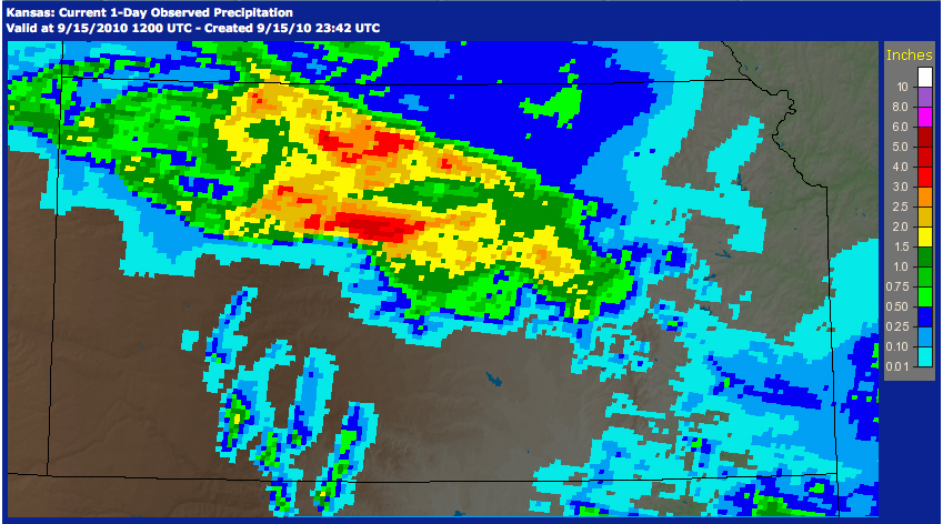
The AHPS 24-hour total precipitation analysis (below) indicated a large swath of substantial rainfall was produced by this convective system, which included amounts in excess of 4 inches in northern Kansas.
")
24-hour precipitation (ending at 12 UTC on 15 September 2010)
At 19:48 UTC, AWIPS images of 1-km resolution MODIS 0.65 µm visible channel and 3.7 µm shortwave IR data (below) revealed the very large swath of wet ground (as indicated by the lighter shades of gray on the shortwave IR image); however, little evidence of this wet ground could be seen on the visible image.

MODIS 0.65 µm visible channel and 3.7 µm shortwave IR images
================================================

MODIS 3. µm shortwave IR image + METAR surface reports
Looking at plots of the surface METAR data (above) and the daily maximum temperatures (below), the large area of wet ground appeared to be holding surface air temperatures down a few degrees compared to adjacent sites across the region.

MODIS 3.7 µm shortwave IR image + daily maximum temperatures for 15 September
On a side note, it is interesting to point out that smoke from wildfires burning in the western US was concentrated along and just ahead of the cold frontal boundary that was moving across Nebraska – this was seen very clearly on a MODIS Red/Green/Blue (RGB) true color image from the SSEC MODIS Today site (below).
 image")
MODIS true color Red/Green/Blue (RGB) image
View only this post
Read Less


")
 and GOES-13 15-minute visible images (right)")


