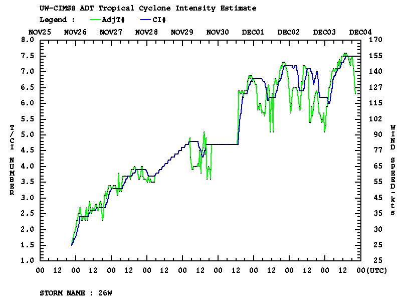
This website works best with a newer web browser such as Chrome, Firefox, Safari or Microsoft Edge. Internet Explorer is not supported by this website.

Increasing levels of GOES-12 sounder noise

Beginning in September 2009, the GOES-12 sounder instrument filter wheel began to experience problems (tied to syncronization issues associated with increased friction in the filter wheel bearing) that resulted in intermittent periods of noisy data and pixel dropouts — this was previously discussed on a 25 November 2009 CIMSS Satellite Blog post. Originally the problem was primarily... Read More

GOES-12 sounder radiance images

GOES-12 sounder radiance images

Beginning in September 2009, the GOES-12 sounder instrument filter wheel began to experience problems (tied to syncronization issues associated with increased friction in the filter wheel bearing) that resulted in intermittent periods of noisy data and pixel dropouts — this was previously discussed on a 25 November 2009 CIMSS Satellite Blog post. Originally the problem was primarily affecting the shortwave IR channels (sounder bands 13-18) — however, at times it had an impact on all 19 of the sounder channels, as seen on a 17 December 2009 multi-panel display of GOES-12 sounder radiance images (above) from the CIMSS Realtime GOES Derived Product Imagery site. This GOES-12 sounder filter wheel problem is currently being investigated by NOAA/NESDIS engineers.

GOES sounder Total Precipitable Water product

GOES sounder Total Precipitable Water product

While this GOES-12 sounder filter wheel problem persists, AWIPS users of GOES sounder Derived Product Imagery (DPI) such as Total Precipitable Water (above) and Cloud Top Height (below) will notice periods of noisy data characterized by widespread pixel drop-outs over the eastern US and adjacent portions of the Gulf of Mexico and the western Atlantic Ocean. Note that the sounder DPI over the western US (using data from GOES-11) does not exhibit any pixel drop-outs.

GOES sounder Cloud Top Height product

GOES sounder Cloud Top Height product

View only this post Read Less

-40º F (-40º C) in eastern Montana

On 15 December 2009, Jordan (located in eastern Montana) won the distinction of recording the first temperature of -40º F (-40º C) or colder in the Lower 48 states during the 2009/2010 winter season. AWIPS images of the MODIS 11.0 µm IR channel data (above) showed a number of areas across eastern... Read More

MODIS 11.0 µm IR images

MODIS 11.0 µm IR images

On 15 December 2009, Jordan (located in eastern Montana) won the distinction of recording the first temperature of -40º F (-40º C) or colder in the Lower 48 states during the 2009/2010 winter season. AWIPS images of the MODIS 11.0 µm IR channel data (above) showed a number of areas across eastern Montana which exhibited surface IR brightness temperatures near -40º (darker blue color enhancement) — also note the much warmer thermal signature (yellow to red colors) of Fort Peck Lake, most of which which was still unfrozen. However, there was also a patch of clouds with relatively warm tops (around -20º C, yellow enhancement) that was moving northeastward across Montana during that time, with surface air temperatures significantly warmer under that blanket of clouds. As the leading edge of this cloud deck began to move over Jordan (surface identifier KJDN), the strong radiational cooling was halted (one has to wonder how much colder Jordan might have gotten had the clouds not moved overhead?). In fact, Glendive (station identifier KGDV) continued to drop to a low of -35º F (-37º C) under clear skies.

A comparison of the AVHRR Cloud Type, Cloud Top Temperature (CTT), and Cloud Top Height (CTH) products at 08:27 UTC or 2:27 am local time (below) showed that this advancing cloud deck was composed of supercooled water droplets, with CTT values near -20º C and CTH values around 3-4 km.

AVHRR Cloud Type, Cloud Top Temperature, and Cloud Height products

AVHRR Cloud Type, Cloud Top Temperature, and Cloud Height products

View only this post Read Less

Snow cover and lake-effect cloud bands following the Upper Midwest blizzard of 08-09 December 2009

MODIS true color and false color images from the SSEC MODIS Today site on 11 December 2009 (above) showed a nice view of the snow cover following the Upper Midwest blizzard of 08 December09 December 2009 — some details on the blizzard are available from the NWS forecast offices at Omaha NE, Minneapolis MN, Davenport IA, Milwaukee WI, and... Read More

MODIS true color and false color images

MODIS true color and false color images

MODIS true color and false color images from the SSEC MODIS Today site on 11 December 2009 (above) showed a nice view of the snow cover following the Upper Midwest blizzard of 08 December09 December 2009 — some details on the blizzard are available from the NWS forecast offices at Omaha NE, Minneapolis MN, Davenport IA, Milwaukee WI, and Green Bay WI. On the false color image, snow appears as shades of cyan (in contrast to supercooled water droplet clouds, which appear as brighter white features). The maximum snow depths across the region at the time of these MODIS images included 32 inches in the Upper Peninsula of Michigan, 18 inches in southern Wisconsin, 17 inches in northern Lower Michigan, 16 inches in Iowa, 12 inches in southern Minnesota, and 10 inches in northern Illinois.

Besides the large lake-effect cloud bands streaming across Lake Superior and Lake Michigan, some other interesting features to note are the smaller lake-effect cloud plumes streaming eastward off the many still-unfrozen lakes in southern Ontario, Canada (northwest of Lake Superior), and also the narrow streaks of snow on the ground across parts of Illinois and Indiana (south of Lake Michigan).

GOES-14 visible images

GOES-14 visible images

McIDAS images of the GOES-14 visible channel (above) showed the evolution of the lake-effect cloud bands over Lake Superior. As part of the ongoing NOAA Science Test, GOES-14 was in Rapid Scan Operations mode on 11 December, supplying imagery at 5-minute intervals. One of the more organized cloud bands had formed across the southwestern portion of Lake Superior, and was moving onshore along the Keweenaw Peninsula of Upper Michigan — this band produced lake-effect snowfall amount of 12 inches at Eagle River and 13 inches at Twin Lakes.

AVHRR visible, 10.8 µm IR, and 3.7 µm IR images

AVHRR visible, 10.8 µm IR, and 3.7 µm IR images

AWIPS images of the AVHRR visible, 10.8 µm IR window, and 3.7 µm shortwave IR channels (above) indicated that many of the lake-effect cloud bands over Lake Superior exhibited 10.8 µm IR brightness temperatures of -20º to -30º C (cyan to darker blue color enhancement), suggesting a possible transition from supercooled water droplets to ice crystal glaciation. However, since many of the bands exhibited a rather warm appearance on the 3.7 µm shortwave IR image (darker gray enhancement) due to reflection of solar radiation off the tops of supercooled water droplet clouds, it appeared that most of the cloud bands had not yet fully glaciated.

MODIS Red/Green/Blue (RGB) images

MODIS Red/Green/Blue (RGB) images

Finally, a larger-scale view with MODIS false-color Red/Green/Blue (RGB) images created using the visible channel, the 2.1 µm near- IR “snow/ice” channel, and the 11.0 µm IR window channel (above) shows a glimpse at the type of RGB capability that will be available with the upcoming AWIPS-2 software. In these particular RGB images, the snow cover appears as varying shades of magenta to blue (depending on the density of trees), while supercooled water droplet clouds are brighter white. Ice crystal clouds also appear as magenta-colored features. Bare ground shows up as varying shades of green.

View only this post Read Less

Lake-effect cloud plumes in the Dakotas

An influx of arctic air (surface plot) moved southeastward across North Dakota and South Dakota in the wake of a large and powerful Midwest blizzard on 09 December 2009. Since many sections of the Missouri river were still unfrozen — the MODIS Sea Surface Temperature product showed that water temperatures were still in... Read More

MODIS visible channel and 2.1 µm near-IR snow/ice channel images

MODIS visible channel and 2.1 µm near-IR "snow/ice channel" images

An influx of arctic air (surface plot) moved southeastward across North Dakota and South Dakota in the wake of a large and powerful Midwest blizzard on 09 December 2009. Since many sections of the Missouri river were still unfrozen — the MODIS Sea Surface Temperature product showed that water temperatures were still in the 30s F — the large difference in temperature created enough instability to allow a number of “lake-effect cloud plumes” to form. AWIPS images of the 1-km resolution MODIS visible channel and 2.1 µm near-IR “snow/ice” channel (above) showed how the snow/ice imagery can be useful for detecting supercooled water droplet clouds against a background of snow cover. Snow and ice are strong absorbers at the 2.1 µm wavelength, so they appear darker (in contrast to supercooled water droplet clouds, which appear as brighter white features). Note that these cloud features were not readily apparent on standard IR imagery, due to the lack of a good temperature contrast between the shallow cloud features and the background snow cover.

A false-color MODIS Red/Green/Blue (RGB) image (below) is another example of using the 2.1 µm data to aid in the detection of supercooled water droplet clouds — the background snow cover appears as varying shades of red, while the supercooled cloud features stand out as brighter white features. The capability create such RGB images will be available in the upcoming AWIPS II software.

MODIS false-color Red/Green/Blue (RGB) image

MODIS false-color Red/Green/Blue (RGB) image

MODIS 250-meter resolution true color and false color images

MODIS 250-meter resolution true color and false color images

A closer view using 250-meter resolution MODIS true color and false color images from the SSEC MODIS Today site shows finer details of the lake-effect cloud plumes over North Dakota (above) and South Dakota (below). On these false-color images, the background snow cover appears as varying shades of cyan.

MODIS 250-meter resolution true color and false color images

MODIS 250-meter resolution true color and false color images

Similar lake-effect cloud plumes were seen on the previous day (08 December 2009) streaming southward from Fort Peck Lake in northeastern Montana.

View only this post Read Less