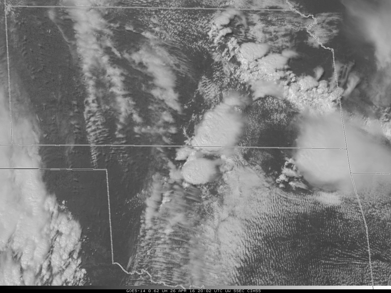
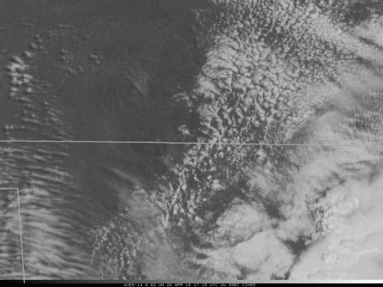
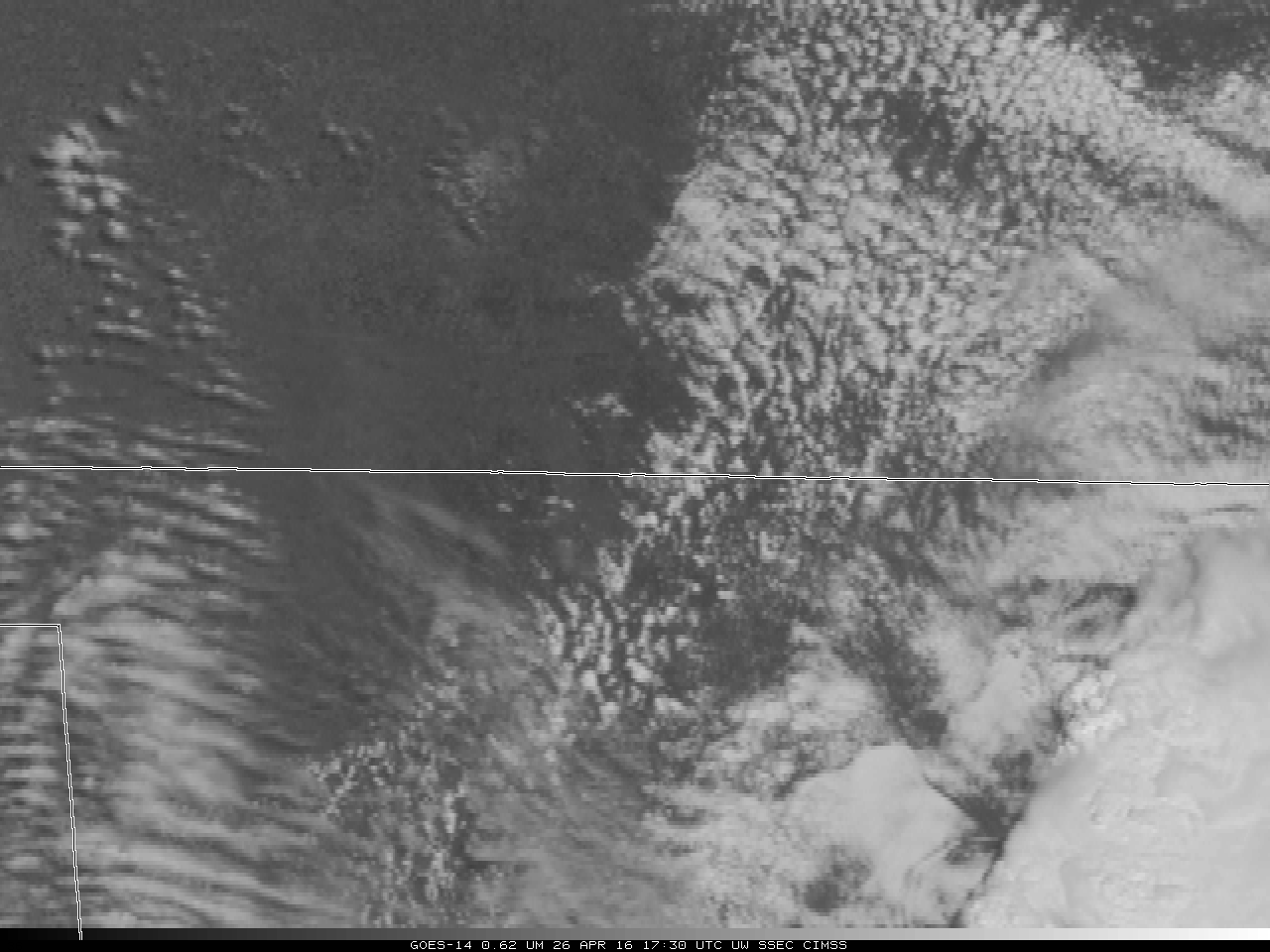
April 26 2016 was a day of well-anticipated severe weather (even a week out!) over the central and southern Plains, with a Moderate Risk of Severe Weather predicted for parts of Nebraska, Kansas, Oklahoma and Texas. The GOES-14 visible animation, above, shows the development of strong thunderstorms in north-central Oklahoma that propagated into south central Kansas, producing hail around 2000 UTC. Note the presence of an... Read More
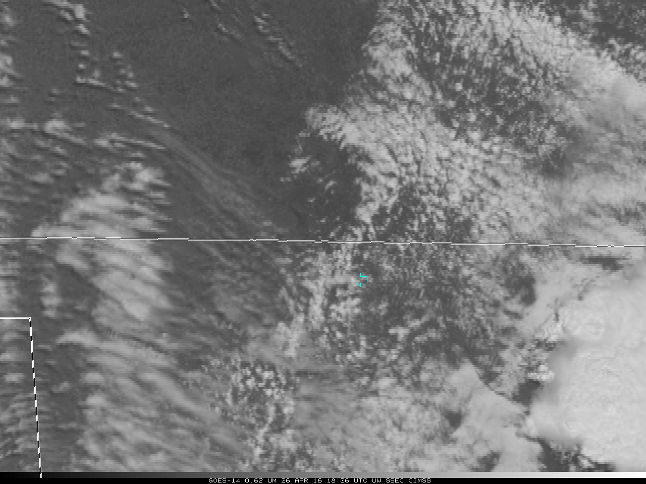
GOES-14 Visible (0.63 µm) Imagery, 26 April 2016. An orphan anvil is indicated by the Green Arrow at the start of the animation (click to play animation)
April 26 2016 was a day of well-anticipated severe weather (even a week out!) over the central and southern Plains, with a Moderate Risk of Severe Weather predicted for parts of Nebraska, Kansas, Oklahoma and Texas. The GOES-14 visible animation, above, shows the development of strong thunderstorms in north-central Oklahoma that propagated into south central Kansas, producing hail around 2000 UTC. Note the presence of an orphan anvil just downstream of the developing convection (to the south of the Green Arrow) at the beginning of the GOES-14 SRSO-R animation (that unfortunately has a 15-minute data gap starting at 1900 UTC).
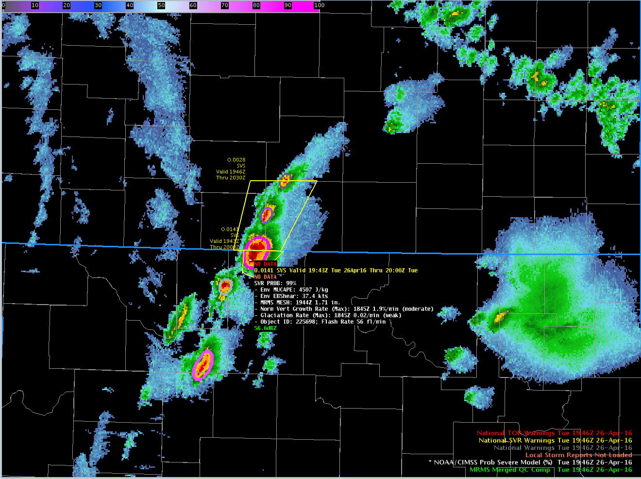
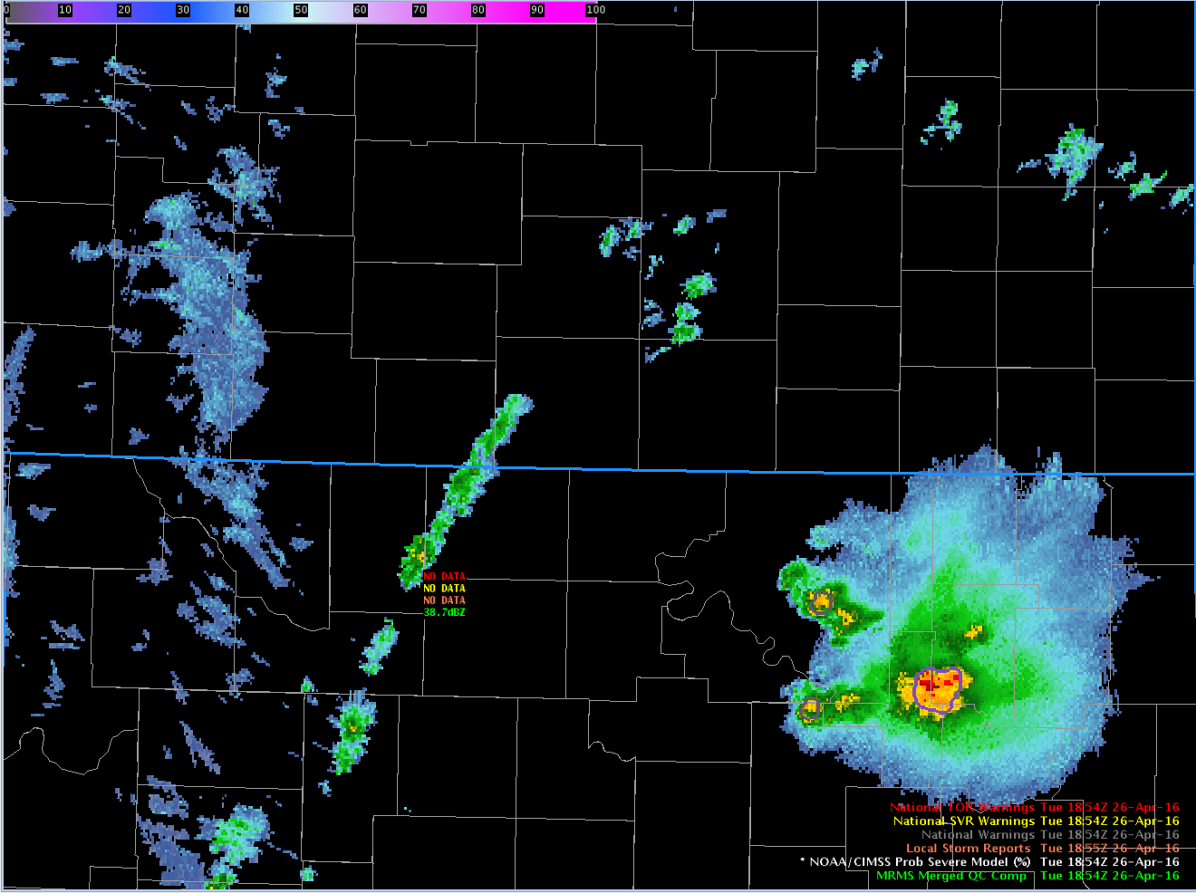
How did the NOAA/CIMSS ProbSevere product perform with this severe cell? ProbSevere provides a probabilistic estimate of whether a cell will produce severe weather within the next 60 minutes. The animation below shows the quick development of the radar feature that became the hail producer. The Satellite Growth of this particular storm was not observed to be strong. Moderate satellite growth and weak glaciation was diagnosed. However, ProbSevere values became very large because of the environment in which the cell developed, because of the presence of large MRMS MESH observations, and active lightning. ProbSevere exceeded a 50% threshold at 1912 UTC, 6 minutes before the Severe Thunderstorm Warning was issued. The Table at the bottom shows the ProbSevere components as a function of time.
According to SPC storm reports, the cell produced a brief rope tornado at 2058 UTC in far southern Kansas. This storm was blogged about at the Hazardous Weather Testbed. Click here and here for blog posts on the environmental instability.

NOAA/CIMSS ProbSevere Output, 1824-1946 UTC on 26 April 2016 (click to play animation)
A zoomed-in animation of the Visible Imagery shows the orphan anvil developing around 1740 UTC. (A rocking animation is here).
GOES-14 Visible (0.63 µm) Imagery, 26 April 2016. The orphan anvil is indicated by the Cyan Arrows through the animation (click to play animation)
| Time (UTC) |
ProbSevere |
MUCAPE |
Env. Bulk Shear |
MRMS MESH (Inches) |
Satellite Growth |
Satellite Glaciation |
# Flashes |
| 1854 |
| 1858 |
20% |
4739 |
41.9 |
0.29 |
1.9% (Moderate) |
0.02 (Weak) |
0 |
| 1900 |
29% |
4702 |
41.8 |
0.45 |
1.9% (Moderate) |
0.02 (Weak) |
0 |
| 1908 |
34% |
4640 |
40.9 |
0.54 |
1.9% (Moderate) |
0.02 (Weak) |
5 |
| 1910 |
47% |
4628 |
40.7 |
0.65 |
1.9% (Moderate) |
0.02 (Weak) |
13 |
| 1912 |
59% |
4623 |
40.4 |
0.65 |
1.9% (Moderate) |
0.02 (Weak) |
24 |
| 1914 |
58% |
4619 |
40.1 |
0.65 |
1.9% (Moderate) |
0.02 (Weak) |
24 |
| 1916 |
58% |
4614 |
39.8 |
0.65 |
1.9% (Moderate) |
0.02 (Weak) |
24 |
| 1918 |
54% |
4614 |
39.8 |
0.60 |
1.9% (Moderate) |
0.02 (Weak) |
24 |
| 1920 |
60% |
4592 |
39.4 |
0.74 |
1.9% (Moderate) |
0.02 (Weak) |
20 |
| 1922 |
65% |
4591 |
39.1 |
0.80 |
1.9% (Moderate) |
0.02 (Weak) |
20 |
| 1924 |
73% |
4591 |
39.1 |
0.80 |
1.9% (Moderate) |
0.02 (Weak) |
25 |
| 1926 |
75% |
4572 |
38.8 |
0.84 |
1.9% (Moderate) |
0.02 (Weak) |
26 |
| 1928 |
88% |
4578 |
38.7 |
1.01 |
1.9% (Moderate) |
0.02 (Weak) |
31 |
| 1930 |
89% |
4578 |
38.7 |
1.01 |
1.9% (Moderate) |
0.02 (Weak) |
36 |
| 1932 |
97% |
4580 |
38.6 |
1.24 |
1.9% (Moderate) |
0.02 (Weak) |
49 |
| 1934 |
97% |
4560 |
38.3 |
1.24 |
1.9% (Moderate) |
0.02 (Weak) |
58 |
| 1936 |
97% |
4544 |
38.1 |
1.24 |
1.9% (Moderate) |
0.02 (Weak) |
58 |
| 1938 |
97% |
4543 |
38.0 |
1.24 |
1.9% (Moderate) |
0.02 (Weak) |
58 |
| 1940 |
97% |
4540 |
37.8 |
1.26 |
1.9% (Moderate) |
0.02 (Weak) |
58 |
| 1942 |
98% |
4528 |
37.7 |
1.53 |
1.9% (Moderate) |
0.02 (Weak) |
56 |
| 1944 |
99% |
4516 |
37.5 |
1.71 |
1.9% (Moderate) |
0.02 (Weak) |
56 |
| 1946 |
99% |
4507 |
37.4 |
1.71 |
1.9% (Moderate) |
0.02 (Weak) |
56 |
View only this post
Read Less
![Suomi NPP VIIRS true-color and false-color RGB images [click to enlarge]](https://cimss.ssec.wisc.edu/satellite-blog/wp-content/uploads/sites/5/2016/05/160503_1657utc_suomi_npp_viirs_truecolor_falsecolor_Labrador_sea_ice_anim.gif)
![GOES-13 Visible (0.63 µm) images [click to play animation]](https://cimss.ssec.wisc.edu/satellite-blog/wp-content/uploads/sites/5/2016/05/160503_goes13_visible_Labrador_Current_sea_ice_anim.gif)
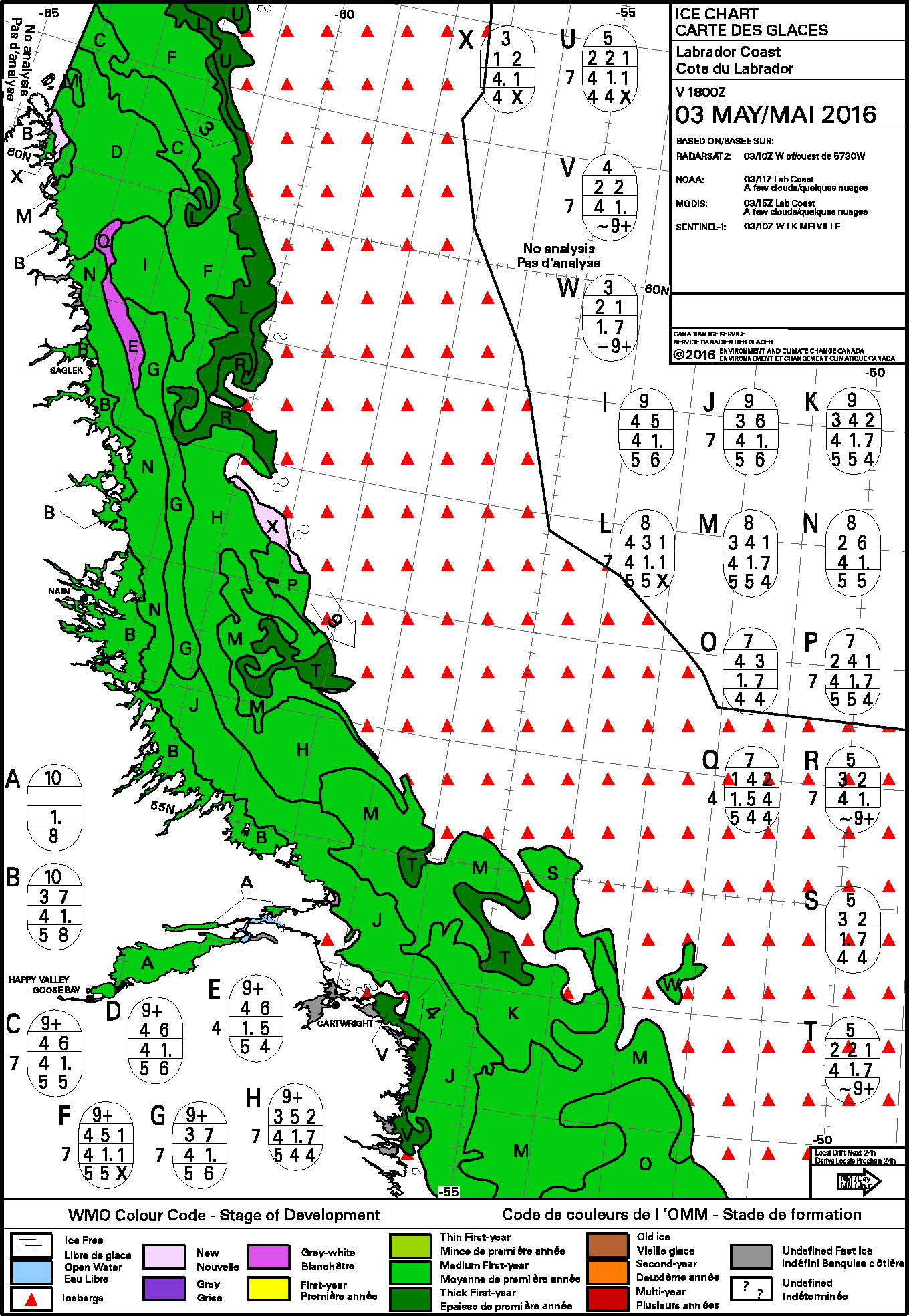
![Ice concentration off the Labrador coast [click to enlarge]](https://cimss.ssec.wisc.edu/satellite-blog/wp-content/uploads/sites/5/2016/05/160503_ice_concentration_Labrador.gif)
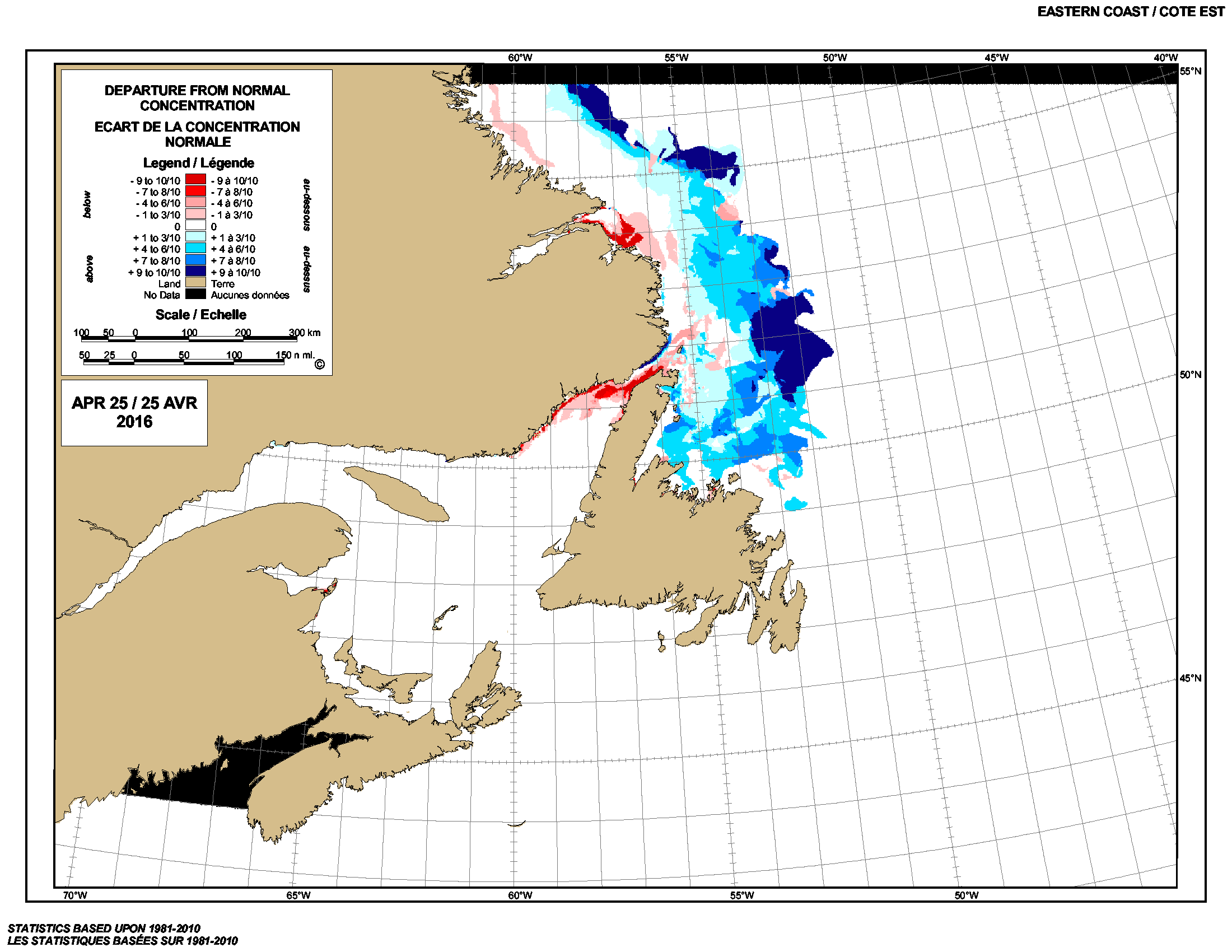
![Ice concentration off the coast of Labrador and Newfoundland [click to enlarge]](https://cimss.ssec.wisc.edu/satellite-blog/wp-content/uploads/sites/5/2016/05/160503_ice_concenration_Newfoundland.gif)

![GOES-14 Visible (0.63 µm) images, with surface plots [click to play MP4 animation]](https://cimss.ssec.wisc.edu/satellite-blog/wp-content/uploads/sites/5/2016/04/960x1280_AGOES14_B1_GOES14_VIS_WY_MT_SD_SPC_CUMULATIVE_23APR2016_2016114_233200_0001PANEL.GIF)
![GOES-14 0.63 µm Visible (left) and 3.9 µm Shortwave Infrared (right) images [click to play MP4 animation]](https://cimss.ssec.wisc.edu/satellite-blog/wp-content/uploads/sites/5/2016/04/960x640_AGOES14_B12_GOES14_VIS_SWIR_SD_FIRE_23FEB_2016115_042400_0002PANELS.GIF)
![GOES-14 Visible (0.63 um) images, with plots of surface weather symbols in cyan and hail reports in yellow [click to play MP4 animation]](https://cimss.ssec.wisc.edu/satellite-blog/wp-content/uploads/sites/5/2016/04/960x1280_AGOES14_B1_GOES14_VIS_IA_IL_SPC_CUMULATIVE_21APR2016_2016112_221600_0001PANEL.GIF)
