Numerous small fires were burning in the Lake Okeechobee area of southern Florida on 20 February 2017. A comparison of GOES-16 ABI (at rapid scan 30 second intervals) and GOES-13 (at routine 15-30 minute intervals) 3.9 µm Shortwave Infrared images (above; also available as a 71 Mbyte animated GIF) showed the “hot spots” —... Read More
![GOES-16 (left) and GOES-13 (right) 3.9 µm Shortwave Infrared images [click to play MP4 animation]](https://cimss.ssec.wisc.edu/satellite-blog/wp-content/uploads/sites/5/2017/02/G16_G13_IR2_FL_20FEB2017_958x638_B72_00173_2017051_210858_204500_0002PANELS.GIF)
GOES-16 (left) and GOES-13 (right) 3.9 µm Shortwave Infrared images [click to play MP4 animation]
Numerous small fires were burning in the Lake Okeechobee area of southern Florida on
20 February 2017. A comparison of GOES-16
ABI (at rapid scan 30 second intervals) and GOES-13
(at routine 15-30 minute intervals) 3.9 µm Shortwave Infrared images
(above; also available as a 71 Mbyte animated GIF) showed the “hot spots” — dark black to yellow to red enhancement, with red being the hottest — associated with these fires. Since many of the fires were agricultural sugar cane burns (which tend to be brief, but intense), the vast majority were not detected using the routine operational 15-30 minute scan interval of GOES-13; only the 30-second interval rapid scan GOES-16 images were able to capture these short-lived events. GOES-16 (the first in the
GOES-R series) will provide the capability of 30-second or 60-second images within special Mesoscale Sectors.
The improved spatial resolution of the GOES-16 data (2-km at satellite sub-point, vs 4-km for GOES-13) also aided in the detection and characterization of the small and short-lived fires.
Fire detection points from the NOAA Hazard Mapping System for 20 February are shown below.
![NOAA Hazard Mapping System fire detection points [click to enlarge]](https://cimss.ssec.wisc.edu/satellite-blog/wp-content/uploads/sites/5/2017/02/170220_noaa_hms_fires_Lake_Okeechobee_Florida.jpeg)
NOAA Hazard Mapping System fire detection points [click to enlarge]
Note: GOES-16 data shown on this page are preliminary, non-operational data and are undergoing on-orbit testing.
View only this post
Read Less
![GOES-16 ABI Visible (0.64 µm) images [click to play animation]](https://cimss.ssec.wisc.edu/satellite-blog/wp-content/uploads/sites/5/2017/02/170226_goes16_visible_Southern_Hemisphere_eclipse_shadow_zoom_2_anim.gif)
![Path of 26 February 2017 solar eclipse shadow [click to enlarge]](http://en.es-static.us/upl/2017/02/SE2017Feb26A.png)
![GOES-16 true-color images [click to play animation]](https://cimss.ssec.wisc.edu/satellite-blog/wp-content/uploads/sites/5/2017/02/2017_SH_solar_eclipse_shadow_truecolor_anim.gif)
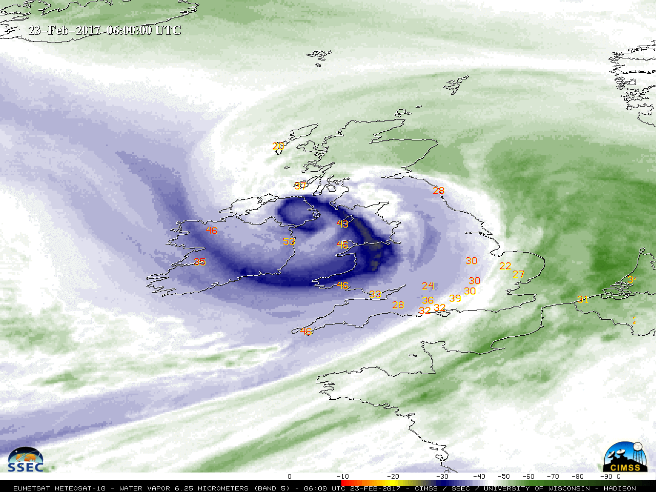
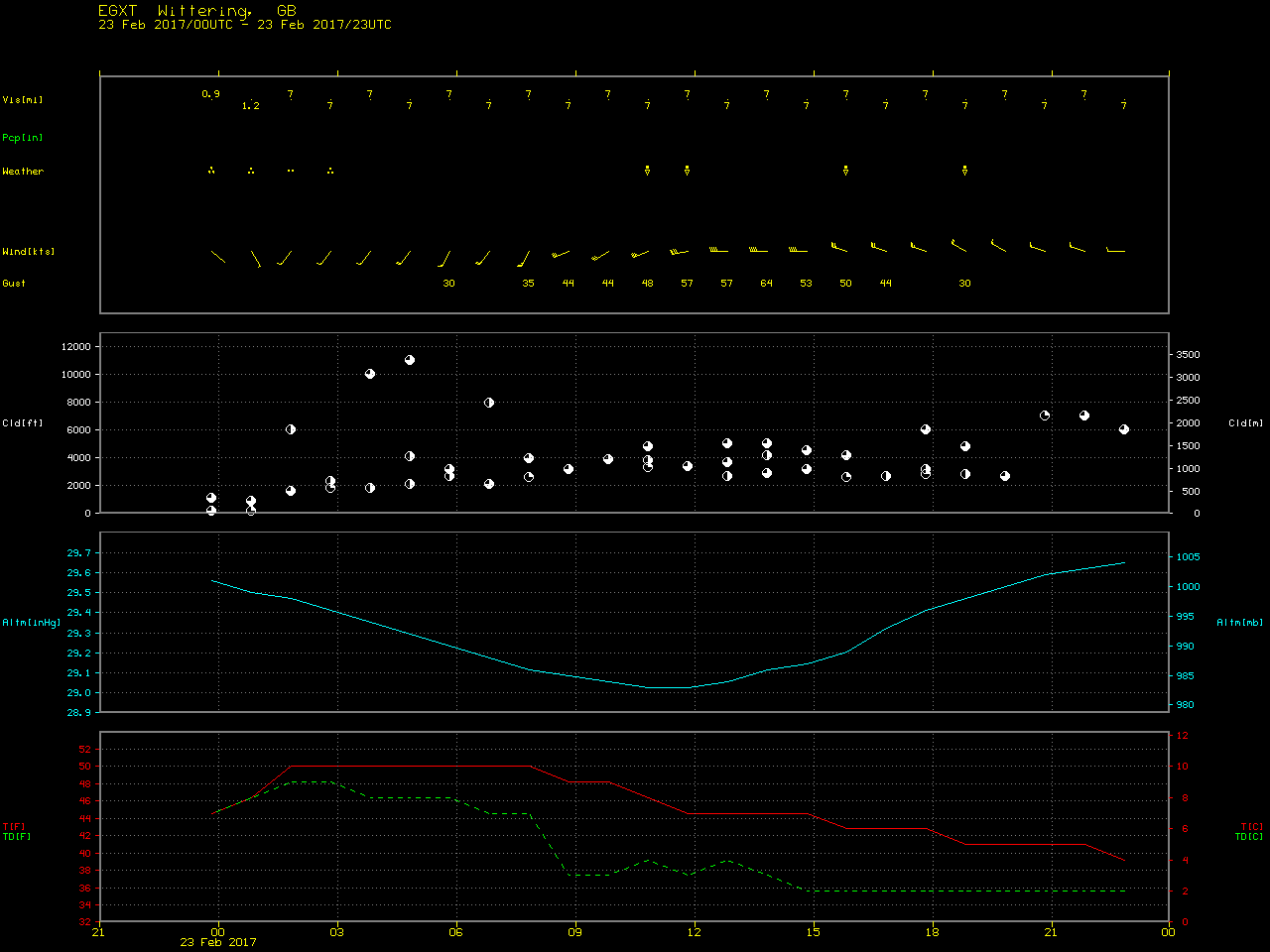
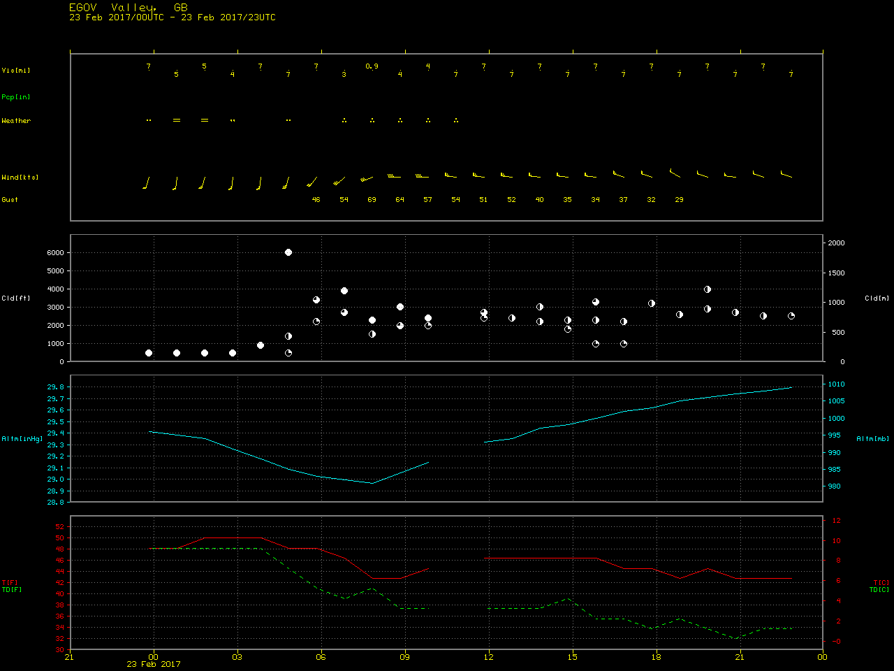
![Meteosat-10 Water Vapor (6.25 µm) images, with hourly surface wind gusts in knots [click to play animation]](https://cimss.ssec.wisc.edu/satellite-blog/wp-content/uploads/sites/5/2017/02/170223_meteosat10_water_vapor_Storm_Doris_anim.gif)
![Meteosat-10 High Resolution Visible (0.8 µm) images, with hourly surface wind gusts in knots [click to play animation]](https://cimss.ssec.wisc.edu/satellite-blog/wp-content/uploads/sites/5/2017/02/170223_meteosat10_visible_Storm_Doris_anim.gif)
![Terra MODIS (1039 UTC), Aqua MODIS (1226 UTC) and Suomi NPP VIIRS (1248 UTC) true-color RGB images [click to enlarge]](https://cimss.ssec.wisc.edu/satellite-blog/wp-content/uploads/sites/5/2017/02/170223_modis_viirs_truecolor_Storm_Doris_anim.gif)
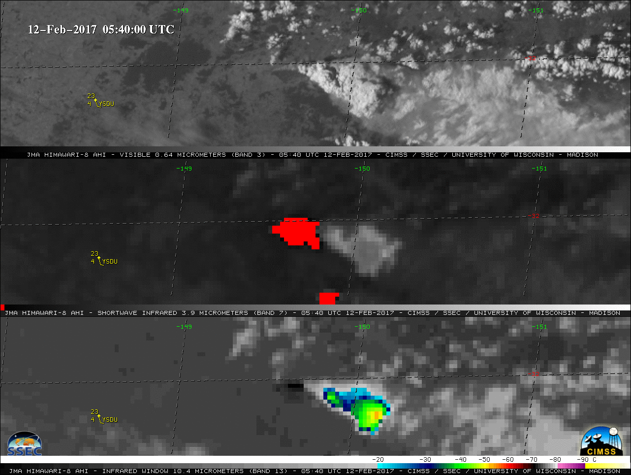
![Himawari-8 0.64 µm Visible (top), 3.9 µm Shortwave Infrared (middle) and 10.4 µm Longwave Infrared Window (bottom) images [click to play animation]](http://pyrocb.ssec.wisc.edu/wp-content/uploads/2017/02/170212_himawari8_Visible_ShortwaveIinfrared_LongwaveInfrared_NSW_Australia_pyrocb_anim.gif)
![Suomi NPP VIIRS and Aqua MODIS true-color images [click to enlarge]](http://pyrocb.ssec.wisc.edu/wp-content/uploads/2017/02/170212_suomi_npp_viirs_aqua_modis_truecolor_NSW_Australia_wildfires_anim.gif)
