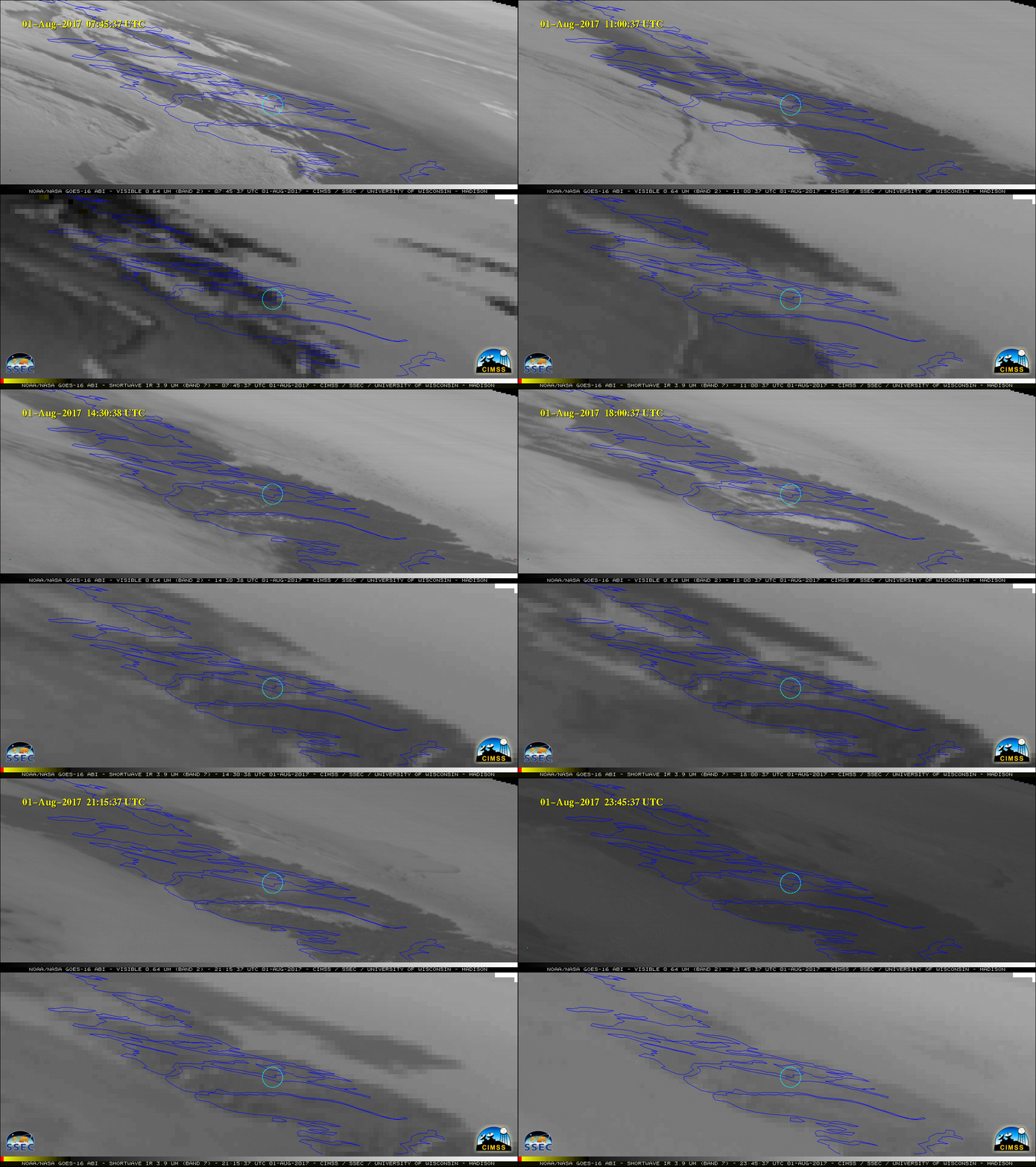
![GOES-16 Visible (0.64 µm) and Shortwave Infrared (3.9 µm) images [click to play animation]](https://cimss.ssec.wisc.edu/satellite-blog/wp-content/uploads/sites/5/2017/08/170801_goes16_Visible_ShortwaveInfrared_Greenlad_fire_anim.gif)
GOES-16 Visible (0.64 µm) and Shortwave Infrared (3.9 µm) images [click to play animation]
* GOES-16 data posted on this page are preliminary, non-operational and are undergoing testing *
GOES-16 “Red” Visible (0.64 µm) and Shortwave Infrared (3.9 µm) images (above; a zoomed-in version is available here) displayed a subtle hazy signature of a smoke plume along with an intermittent “hot spot” (darker black pixels) associated with a small fire — located near the center of the cyan circle — that was burning close to the southwest coast of Greenland on 01 August 2017. The approximate latitude/longitude coordinates of the fire were 67.87º N / 51.48º W, a location about halfway between Ilulissat (station identifier BGJN) and Kangerlussuaq (station identifier BGSF) and about halfway between the western edge of the Greenland Ice Sheet and the west coast .
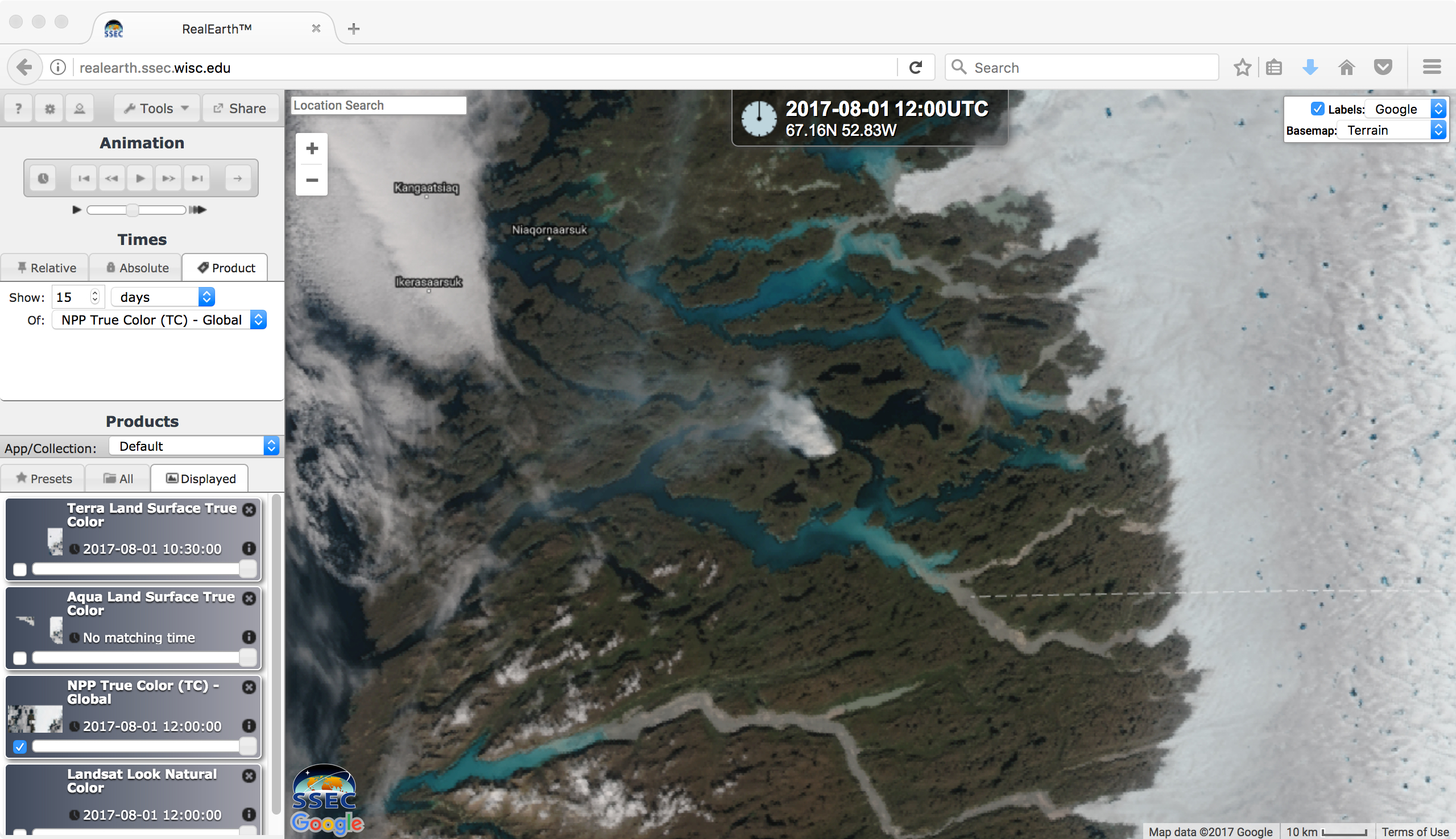
Closer views using daily composites of 250-meter resolution Terra and Aqua MODIS true-color Red/Green/Blue (RGB) images (from 30 July to 04 August), sourced from RealEarth (below) indicated that the fire may have started close to 1540 UTC on 31 July — when a small white smoke and/or cloud feature (just north of the cursor) was seen at the fire source location on the Terra image (overpass time). The Aqua overpass time was around 1600 UTC.
![Daily composites of Terra MODIS true-color RGB images, from 30 July to 04 August [click to enlarge]](https://cimss.ssec.wisc.edu/satellite-blog/wp-content/uploads/sites/5/2017/08/170731-170804_terra_modis_truecolor_Greenland_fire_anim.gif)
Daily composites of Terra MODIS true-color RGB images, from 30 July to 04 August [click to enlarge]
![Daily composites of Aqua MODIS true-color RGB images, from 30 July to 04 August [click to enlarge]](https://cimss.ssec.wisc.edu/satellite-blog/wp-content/uploads/sites/5/2017/08/170731-170804_aqua_modis_truecolor_Greenland_fire_anim.gif)
Daily composites of Aqua MODIS true-color RGB images, from 30 July to 04 August [click to enlarge]
![Daily composites Suomi NPP VIIRS true-color RGB images,.from 31 July to 04 August [click to enlarge]](https://cimss.ssec.wisc.edu/satellite-blog/wp-content/uploads/sites/5/2017/08/170731-170804_suomi_npp_viirs_truecolor_Greenland_fire_anim.gif)
Daily composites of Suomi NPP VIIRS true-color RGB images,.from 31 July to 04 August [click to enlarge]
![Landsat-8 false-color RGB image [click to enlarge]](https://cimss.ssec.wisc.edu/satellite-blog/wp-content/uploads/sites/5/2017/08/170803_1507utc_landsat8_falsecolor_Greenland_fire_anim.gif)
Landsat-8 OLI false-color RGB image [click to enlarge]
![Landsat-8 false-color images on 27 July, 03 August and 05 August [click to enlarge]](https://cimss.ssec.wisc.edu/satellite-blog/wp-content/uploads/sites/5/2017/08/170727-170803_170805_landsat8_falsecolor_Greenland_fire_anim.gif)
Landsat-8 OLI false-color images on 27 July, 03 August and 05 August [click to enlarge]
Credit to Mark Ruminski (NOAA/NESDIS) for first bringing this interesting event to our attention.
===== 09 August Update =====
The animations of daily Terra and Aqua true-color RGB images (below) have been extended to 09 August and 08 August, respectively.
![Daily composites of Terra MODIS true-color RGB images, from 30 July to 09 August [click to enlarge]](https://cimss.ssec.wisc.edu/satellite-blog/wp-content/uploads/sites/5/2017/08/170730-170809_terra_modis_truecolor_Greenland_fire_anim.gif)
Daily composites of Terra MODIS true-color RGB images, from 30 July to 09 August [click to enlarge]
![Daily composites of Aqua MODIS true-color RGB images, from 30 July to 08 August [click to enlarge]](https://cimss.ssec.wisc.edu/satellite-blog/wp-content/uploads/sites/5/2017/08/170730-170808_aqua_modis_truecolor_Greenland_fire_anim.gif)
Daily composites of Aqua MODIS true-color RGB images, from 30 July to 08 August [click to enlarge]
![Daily composites of Suomi NPP VIIRS true-color RGB images, from 04-09 August, with fire detection points plotted in red [click to enlarge]](https://cimss.ssec.wisc.edu/satellite-blog/wp-content/uploads/sites/5/2017/08/170804-170809_suomi_npp_viirs_truecolor_fire_detections_Greenland_anim.gif)
Daily composites of Suomi NPP VIIRS true-color RGB images, from 04-09 August, with fire detection points plotted in red [click to enlarge]
===== 12 August Update =====
![Landsat-8 OLI false-color images on 03, 05 and 12 August [click to enlarge]](https://cimss.ssec.wisc.edu/satellite-blog/wp-content/uploads/sites/5/2017/08/170803_170805_170812_landsat8_falsecolor_Greenland_fire_anim.gif)
Landsat-8 OLI false-color images on 03, 05 and 12 August [click to enlarge]
Related sites:
View only this post Read Less
![GOES-15, GOES-14, GOES-16 and G0ES-13 Visible images, with SPC storm reports of hail size plotted in red [click to play animation]](https://cimss.ssec.wisc.edu/satellite-blog/wp-content/uploads/sites/5/2017/08/170802_goes15_goes14_goes16_goes13_visible_CO_anim.gif)
![GOES-15, GOES-14, GOES-16 and GOES-13 Visible images, with SPC storm reports of hail size plotted in red [click to play animation]](https://cimss.ssec.wisc.edu/satellite-blog/wp-content/uploads/sites/5/2017/08/170802_goes15_goes14_goes16_goes13_visible_CO_zoom_anim.gif)



/ARCTIC2017_07_31_212.gif)
/ARCTIC2017_07_31_212_aqua.gif)
/ARCTIC2017_07_31_212_npp.gif)
/ARCTIC2017_08_03_215.gif)