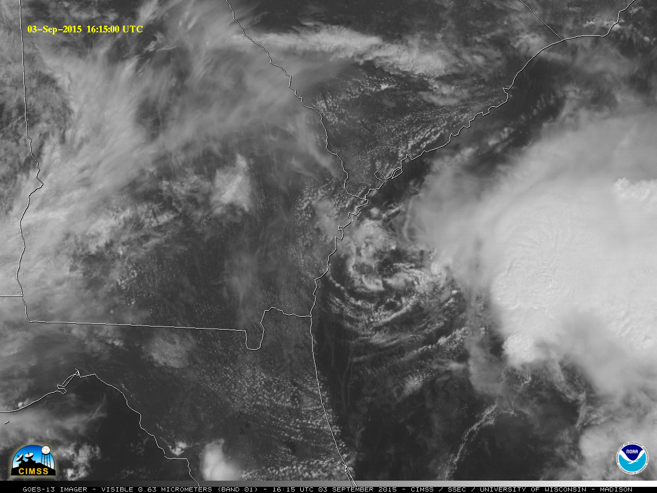
GOES-13 (GOES-East) Visible (0.63 µm) images (above; click to play animation) revealed the low-level circulation of the remnants of Tropical Storm Erika moving off the coast of Georgia early in the day on 03 September 2015 (15 UTC surface analysis). Although there was one brief convective burst over the low-level circulation center (LLCC), it is unclear whether... Read More
![GOES-13 Visible (0.63 µm) images [click to play animation]](https://cimss.ssec.wisc.edu/satellite-blog/wp-content/uploads/sites/5/2015/09/960x1280_AGOES13_B1_G13_VIS_ERIKA_2_2015246_161500.GIF)
GOES-13 Visible (0.63 µm) images [click to play animation]
GOES-13
(GOES-East) Visible (0.63 µm) images
(above; click to play animation) revealed the low-level circulation of the remnants of
Tropical Storm Erika moving off the coast of Georgia early in the day on
03 September 2015 (
15 UTC surface analysis). Although there was one brief convective burst over the low-level circulation center (LLCC), it is unclear whether this was initiated by an outflow boundary from the ongoing thunderstorm activity farther offshore or was aided by enhanced boundary layer convergence in the vicinity of the LLCC.
During the preceding nighttime hours, the remnant LLCC could be seen on a Suomi NPP VIIRS Day/Night Band image at 0631 UTC or 2:31 AM local time (below), still inland over southeastern Georgia.
![Suomi NPP VIIRS Day/Night Band (0.7 µm) and Infrared (11.45 µm) images [click to enlarge]](https://cimss.ssec.wisc.edu/satellite-blog/wp-content/uploads/sites/5/2015/09/150903_0631utc_suomi_npp_viirs_dnb_ir_Erika_remnants_anim.gif)
Suomi NPP VIIRS Day/Night Band (0.7 µm) and Infrared (11.45 µm) images [click to enlarge]
The LLCC was also seen on the morning Terra MODIS Visible (0.64 µm) image
(below); the coldest MODIS Infrared (11.0 µm) cloud-top IR brightness temperatures associated with the deep convection east of the LLCC were -82º C
(violet color enhancement).
![Terra MODIS Visible (0.64 µm) and Infrared (11.0 µm) images [click to enlarge]](https://cimss.ssec.wisc.edu/satellite-blog/wp-content/uploads/sites/5/2015/09/150903_1550utc_modis_visible_ir_Erika_remnants_anim.gif)
Terra MODIS Visible (0.64 µm) and Infrared (11.0 µm) images [click to enlarge]
The 10-day motion of the
vorticity field associated with Tropical Storm Erika (and its remnants) can be followed using the atmospheric motion vector (AMV) 850 hPa Relative Vorticity product from the
CIMSS Tropical Cyclones site
(below; click to play animation).
![Atmospheric motion vector 850 hPa Relative Vorticity product [click to play animation]](https://cimss.ssec.wisc.edu/satellite-blog/wp-content/uploads/sites/5/2015/09/20150825.06.NWAtlantic.850mbRelVorticityLarge.png)
Atmospheric motion vector 850 hPa Relative Vorticity product [click to play animation]
View only this post
Read Less
![GOES-13 Visible (0.63 µm) images [click to play animation]](https://cimss.ssec.wisc.edu/satellite-blog/wp-content/uploads/sites/5/2015/09/150903_goes13_visible_Erika_remnants_anim.gif)
![Atmospheric motion vector 850 hPa Relative Vorticity product [click to play animation]](https://cimss.ssec.wisc.edu/satellite-blog/wp-content/uploads/sites/5/2015/09/150825-0903_850mb_reletive_vorticity_TS_Erika_anim.gif)
![GOES-13 Visible (0.63 um) and Infrared (10.7 um) images [click to enlarge]](https://cimss.ssec.wisc.edu/satellite-blog/wp-content/uploads/sites/5/2015/08/150831_0845utc_goes13_visible_ir_Hurricane_Fred_anim.gif)
![DMSP SSMIS 85 GHz microwave image [click to enlarge]](https://cimss.ssec.wisc.edu/satellite-blog/wp-content/uploads/sites/5/2015/08/150831_0904utc_ssmis_mw_Fred.gif)
![Meteosat-10 Infrared (10.8 um) images with overlay of Tropical Overshooting Top product [click to enlarge]](https://cimss.ssec.wisc.edu/satellite-blog/wp-content/uploads/sites/5/2015/08/150831_14-17utc_ir_tot_Fred_anim.gif)
![Suomi NPP VIIRS true-color image composite [click to enlarge]](https://cimss.ssec.wisc.edu/satellite-blog/wp-content/uploads/sites/5/2015/08/150829_suomi_npp_viirs_truecolor_Kilo_Ignacio_Jimena.jpg)
![GOES-15 Infrared (10.7 µm) images [click to play animation]](https://cimss.ssec.wisc.edu/satellite-blog/wp-content/uploads/sites/5/2015/08/150829-30_goes15_ir_Kilo_Ignacio_Jimena_anim.gif)
![MIMIC TPW product [click to play animation]](https://cimss.ssec.wisc.edu/satellite-blog/wp-content/uploads/sites/5/2015/08/150828-30_mimic_tpw_anim.gif)
![MIMIC Total Precipitable Water product [click to play animation]](https://cimss.ssec.wisc.edu/satellite-blog/wp-content/uploads/sites/5/2015/08/150821-0901_mimic_tpw_Pacific_anim.gif)
