
A series of GCOM-W1 AMSR2 swaths during the period from 2256 UTC on 28 November to 1692 UTC on 30 November 2018 (above) showed the global coverage of Total Precipitable Water and Wind Speed products from that polar-orbiting satellite.A closer look just south of the Atlantic provinces of Canada (above) showed... Read More
![GCOM-W! AMSR2 Total Precipitable Water and Wind Speed products, from 2256 UTC on 28 November to 1692 UTC on 30 November [click to play animation]](https://cimss.ssec.wisc.edu/satellite-blog/wp-content/uploads/sites/5/2018/11/amsr2_tpw_world-20181130_160253.png)
GCOM-W1 AMSR2 Total Precipitable Water and Wind Speed products, from 2256 UTC on 28 November to 1692 UTC on 30 November [click to play animation]
A series of
GCOM-W1 AMSR2 swaths during the period from 2256 UTC on 28 November to 1692 UTC on 30 November 2018
(above) showed the global coverage of Total Precipitable Water and Wind Speed products from that polar-orbiting satellite.
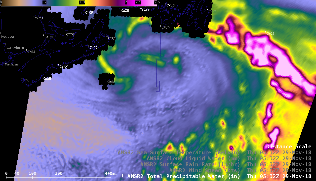
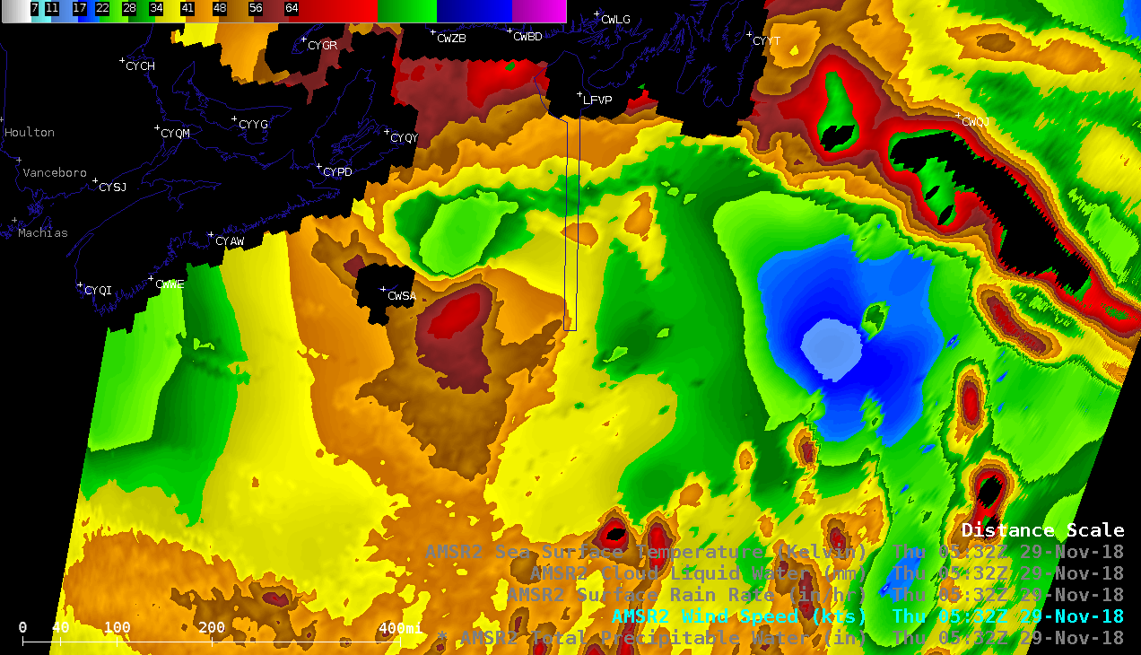
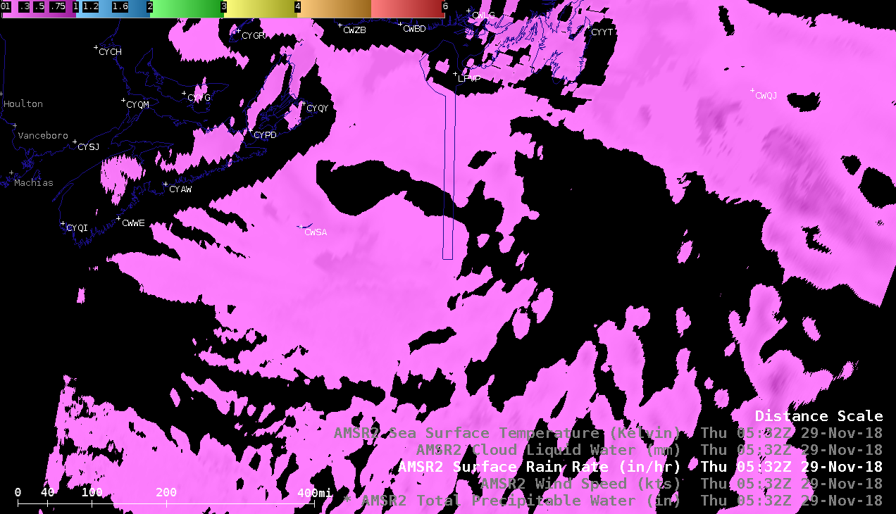
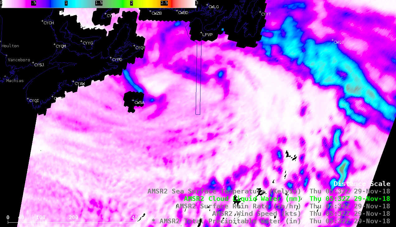
![GCOM-W1 AMSR2 Total Precipitable Water, Wind Speed, Surface Rain Rate and Cloud Liquid Water products [click to enlarge]](https://cimss.ssec.wisc.edu/satellite-blog/wp-content/uploads/sites/5/2018/11/181129_0532utc_gcomW1_amsr2_tpw_windspeed_rainRate_cloudLiquidWater_Canadian_Maritimes_anim.gif)
GCOM-W1 AMSR2 Total Precipitable Water, Wind Speed, Surface Rain Rate and Cloud Liquid Water products [click to enlarge]
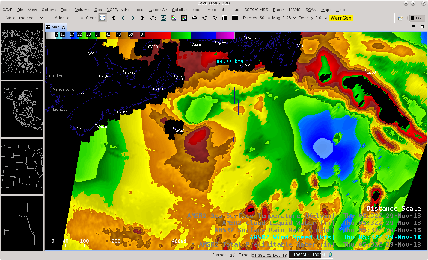
A closer look just south of the Atlantic provinces of Canada
(above) showed a comparison of
Total Precipitable Water,
Wind Speed,
Surface Rain Rate and
Cloud Liquid Water products over a strong mid-latitude cyclone at
0545 UTC on 29 November (the 0532 UTC time stamp on the images denotes the beginning time of that particular satellite swath).
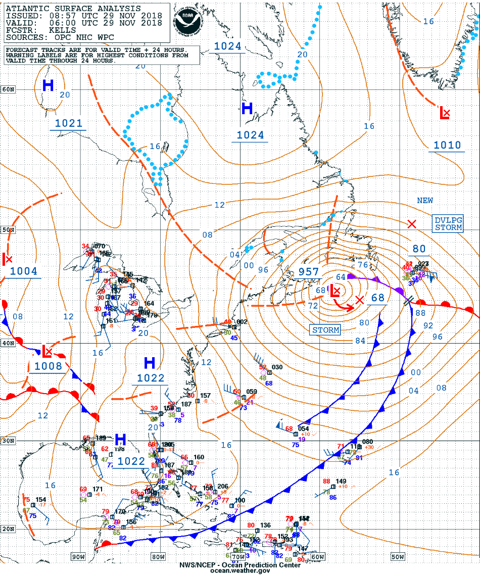
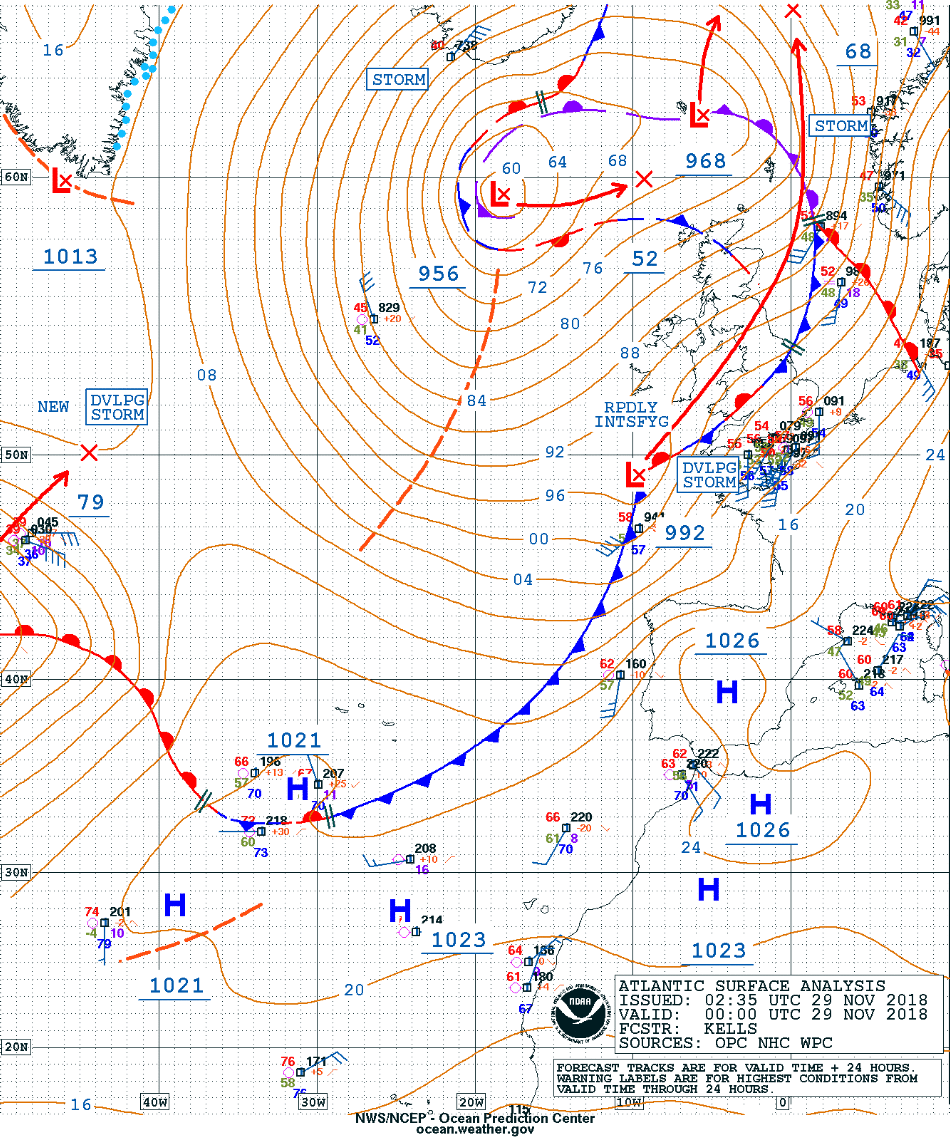
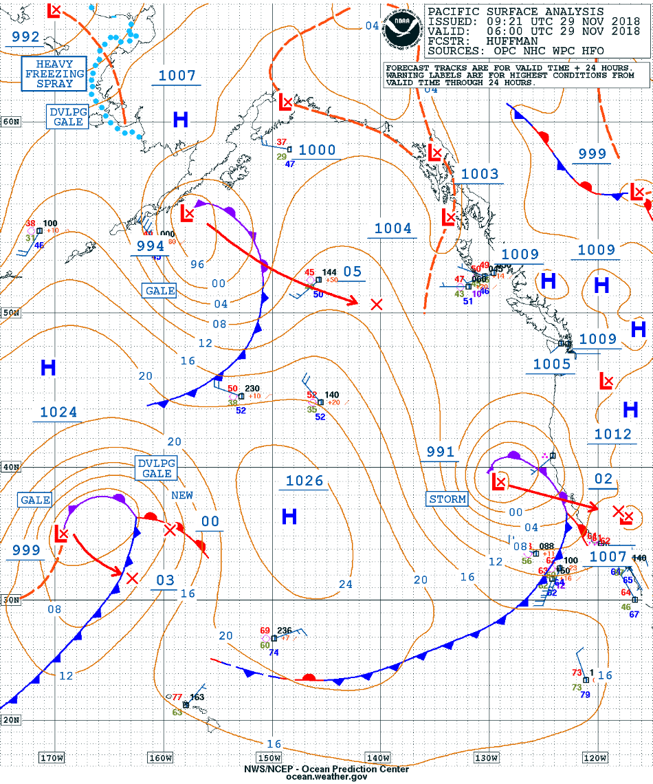
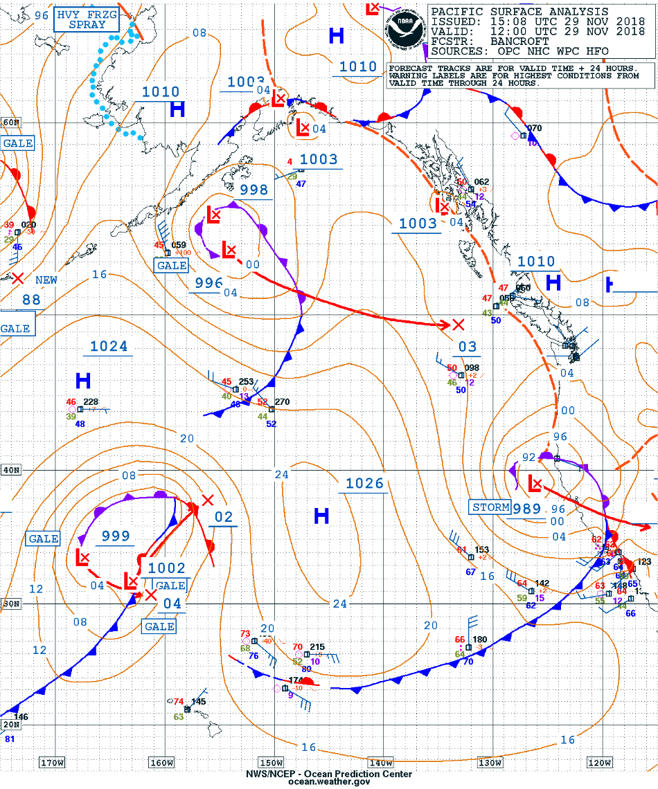
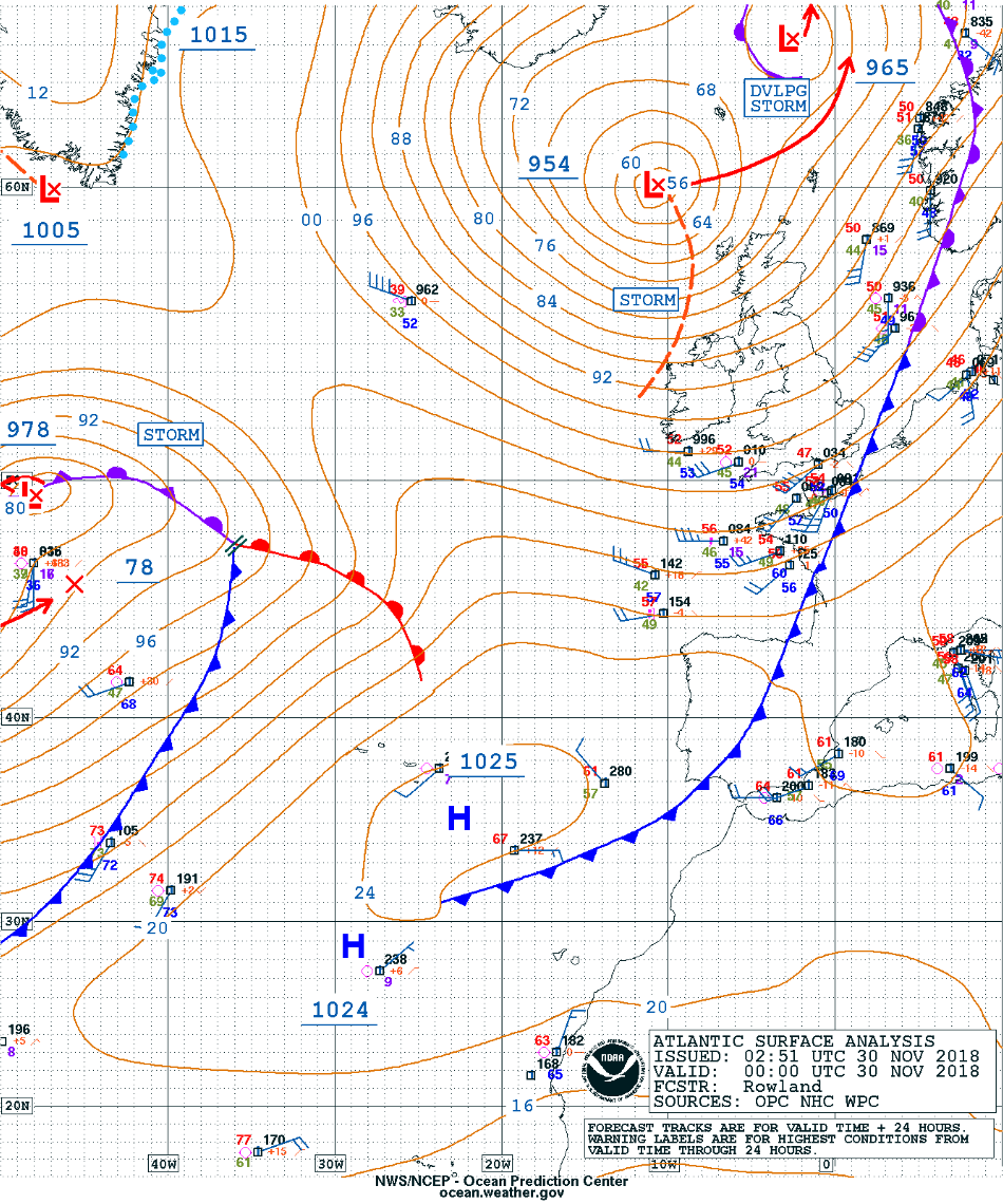
Surface analyses from the OPC (below) classified this low pressure system as Hurricane Force at 00 UTC and Storm Force at 06 UTC — however, AMSR2 ocean surface wind speeds were as high as 71 knots west of the surface low, 84.8 knots north of the low and 95.6 knots in the vicinity of the occluded front.
![Surface analyses at 00 UTC and 06 UTC [click to enlarge]](https://cimss.ssec.wisc.edu/satellite-blog/wp-content/uploads/sites/5/2018/11/181129_00utc_06utc_surface_analyses_anim.gif)
Surface analyses at 00 UTC and 06 UTC [click to enlarge]
Shortly after the overpass of GCOM-W1, additional views of the western portion of this storm were provided by Aqua MODIS and NOAA-20 VIIRS
(below). (note: the NOAA-20 VIIRS images are incorrectly labeled as Suomi NPP)
![Aqua MODIS Water Vapor (6.7 µm) and Infrared Window (11.0 µm) images at 0543 UTC [click to enlarge]](https://cimss.ssec.wisc.edu/satellite-blog/wp-content/uploads/sites/5/2018/11/181129_0543utc_aqua_modis_waterVapor_infraredWindow_Canadian_Maritimes_anim.gif)
Aqua MODIS Water Vapor (6.7 µm) and Infrared Window (11.0 µm) images at 0543 UTC [click to enlarge]
![NOAA-20 VIIRS Day/Night Band (0.7 µm) and Infrared Window (11.45 µm) images at 0557 UTC [click to enlarge]](https://cimss.ssec.wisc.edu/satellite-blog/wp-content/uploads/sites/5/2018/11/181129_0557utc_noaa20_viirs_dayNightBand_infraredWindow_Canadian_Maritimes_anim.gif)
NOAA-20 VIIRS Day/Night Band (0.7 µm) and Infrared Window (11.45 µm) images at 0557 UTC [click to enlarge]
Another overpass of GCOM-W1 about 10 hours later continued to show a broad region of strong post-frontal westerly winds to the south of the storm center
(below). During that period, the occluded low continued to deepen from 957 to 952 hPa (
surface analyses).
![GCOM-W1 AMSR2 Total Precipitable Water, Wind Speed at 0532 and 1529 UTC [click to enlarge]](https://cimss.ssec.wisc.edu/satellite-blog/wp-content/uploads/sites/5/2018/11/181129_0532utc_1520utc_gcomW1_amsr2_totalPrecipitableWater_windSpeed_Atlantic_anim.gif)
GCOM-W1 AMSR2 Total Precipitable Water and Wind Speed products at 0532 and 1529 UTC [click to enlarge]
Additional features seen in the AMSR2 Total Precipitable Water and Wind Speed products in other parts of the world included the following:
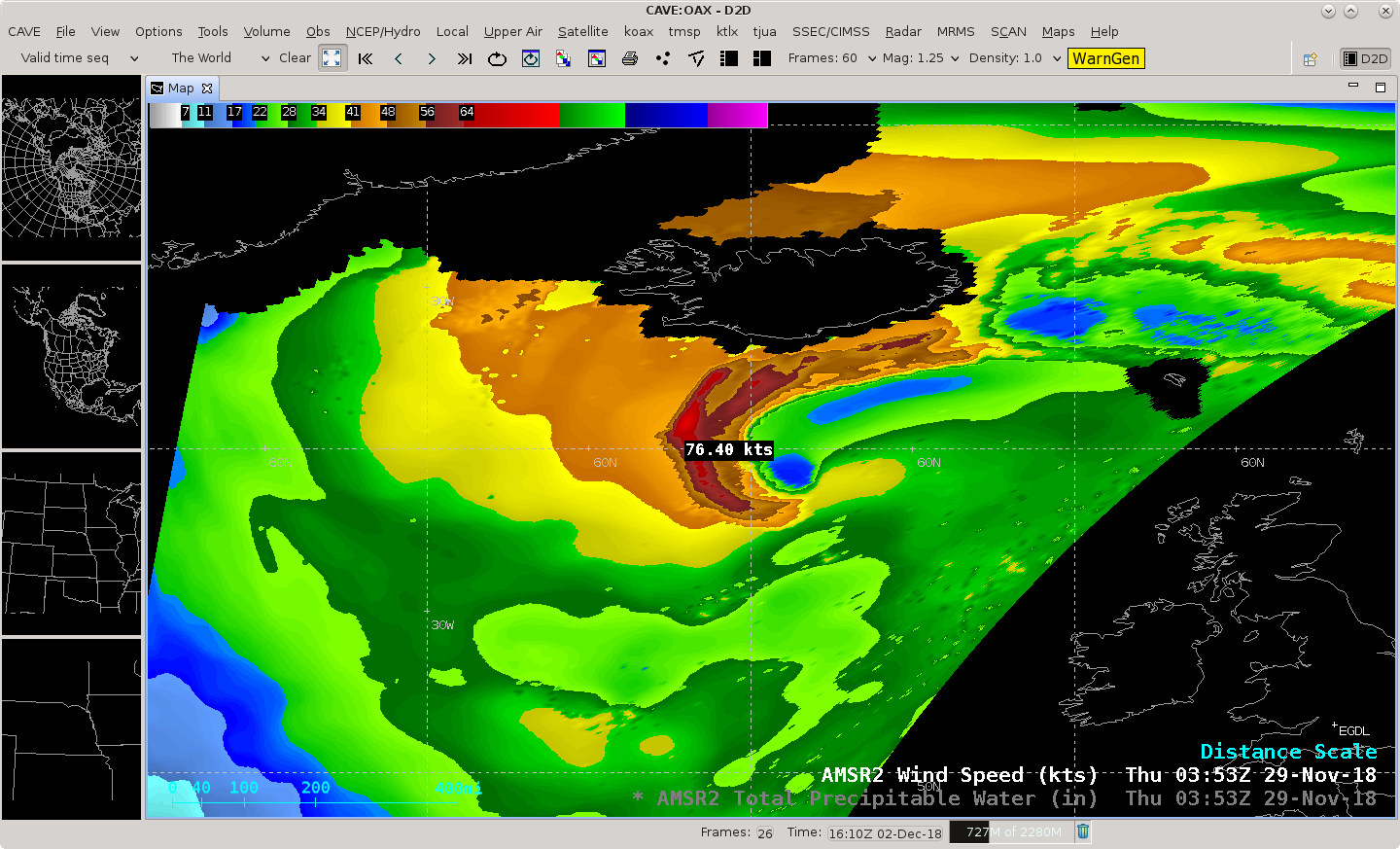
![GCOM-W1 AMSR2 Total Precipitable Water and Wind Speed products at 0353 UTC on 29 November [click to enlarge]](https://cimss.ssec.wisc.edu/satellite-blog/wp-content/uploads/sites/5/2018/11/181129_0353utc_gcomW1_amsr2_totalPrecipitableWater_windSpeed_Iceland_anim.gif)
GCOM-W1 AMSR2 Total Precipitable Water and Wind Speed products south of Iceland at 0353 UTC on 29 November [click to enlarge]
Low pressure south of Iceland (
surface analyses), with an ocean surface wind speed of
76 knots (above).
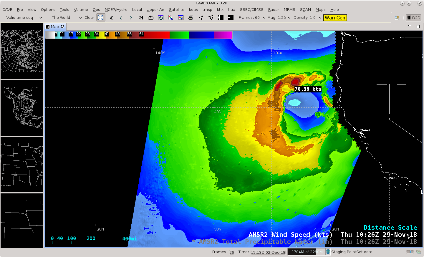
![GCOM-W1 AMSR2 Total Precipitable Water and Wind Speed products off the US West Coast at 1026 UTC on 29 November [click to enlarge]](https://cimss.ssec.wisc.edu/satellite-blog/wp-content/uploads/sites/5/2018/11/181129_1026utc_gcomW1_amsr2_totalPrecipitableWater_windSpeed_US_West_Coast_anim.gif)
GCOM-W1 AMSR2 Total Precipitable Water and Wind Speed products off the US West Coast at 1026 UTC on 29 November [click to enlarge]
Low pressure off the US West Coast (
surface analyses), with an ocean surface wind speed of
70 knots (above).
![GCOM-W1 AMSR2 Total Precipitable Water and Wind Speed products north of Hawai'i at 1202 UTC on 29 November [click to enlarge]](https://cimss.ssec.wisc.edu/satellite-blog/wp-content/uploads/sites/5/2018/11/181129_1202utc_gcomW1_amsr2_totalPrecipitableWater_windSpeed_Hawaii_anim.gif)
GCOM-W1 AMSR2 Total Precipitable Water and Wind Speed products north of Hawai’i at 1202 UTC on 29 November [click to enlarge]
Low pressure and a cold front northwest of Hawai’i (
surface analysis), with a long fetch of
tropical moisture and widespread ocean surface wind speeds of 60-70 knots
(above).
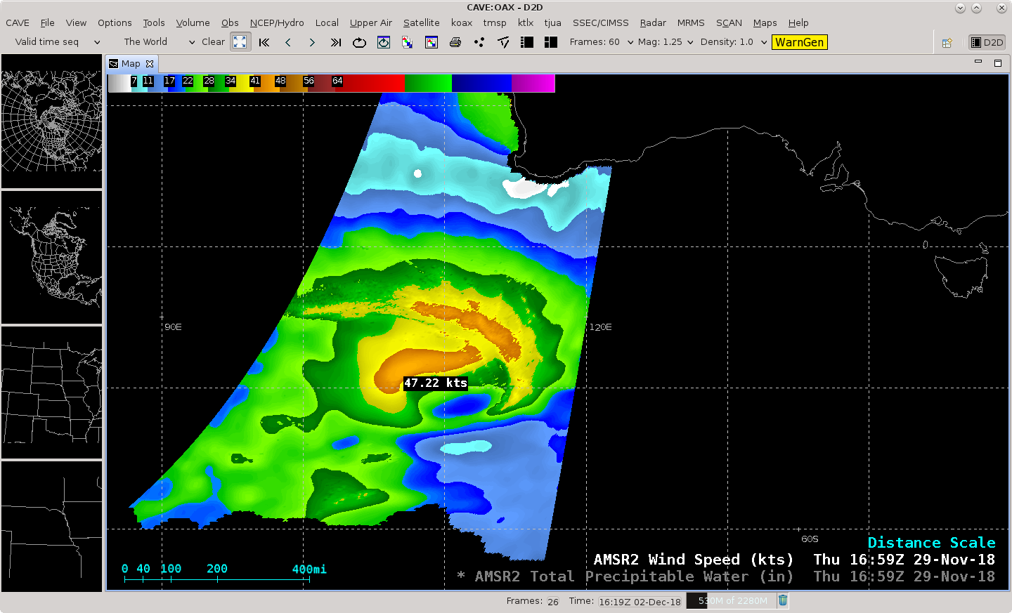
![GCOM-W1 AMSR2 Total Precipitable Water and Wind Speed products southwest of Australia at 1659 UTC on 29 November [click to enlarge]](https://cimss.ssec.wisc.edu/satellite-blog/wp-content/uploads/sites/5/2018/11/181129_1659utc_gcomW1_amsr2_totalPrecipitableWater_windSpeed_Australia_anim.gif)
GCOM-W1 AMSR2 Total Precipitable Water and Wind Speed products southwest of Australia at 1659 UTC on 29 November [click to enlarge]
Low pressure southwest of Australia, with an ocean surface wind speed of
47 knots (above).
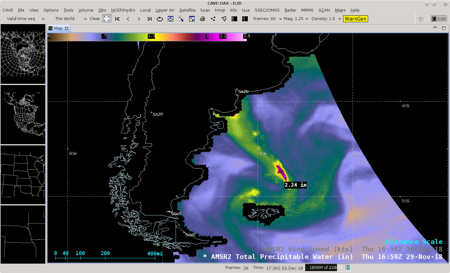
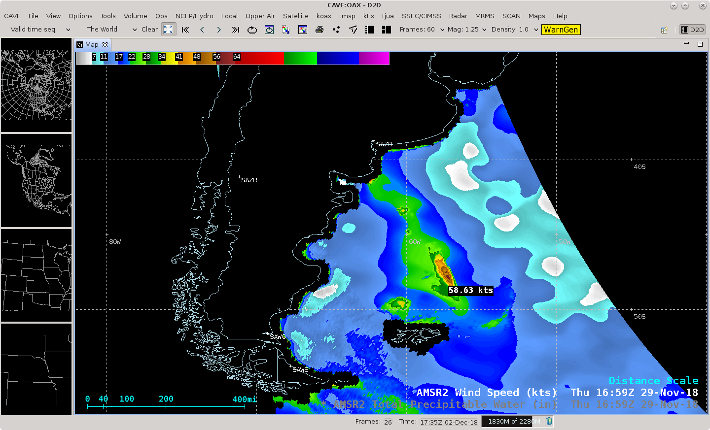
![GCOM-W1 AMSR2 Total Precipitable Water and Wind Speed products southeast of Argentina at 1659 UTC on 29 November [click to enlarge]](https://cimss.ssec.wisc.edu/satellite-blog/wp-content/uploads/sites/5/2018/11/181129_1659utc_181129_1659utc_gcomW1_amsr2_totalPrecipitableWater_windSpeed_Argentina_anim.gif)
GCOM-W1 AMSR2 Total Precipitable Water and Wind Speed products southeast of Argentina at 1659 UTC on 29 November [click to enlarge]
Low preesure and a cold front southeast of Argentina, with TPW as high as
2.2 inches and an ocean surface wind speed of
58.6 knots (above).
![GCOM-W1 AMSR2 Total Precipitable Water and Wind Speed products over the North Sea at 0259 UTC on 30 November [click to enlarge]](https://cimss.ssec.wisc.edu/satellite-blog/wp-content/uploads/sites/5/2018/11/181130_0259utc_gcomW1_amsr2_totalPrecipitableWater_windSpeed_North_Sea_anim.gif)
GCOM-W1 AMSR2 Total Precipitable Water and Wind Speed products over the Norwegian Sea at 0259 UTC on 30 November [click to enlarge]
Low pressure over the Norwegian Sea (
surface analysis), with an ocean surface wind speed of
75 knots (above).
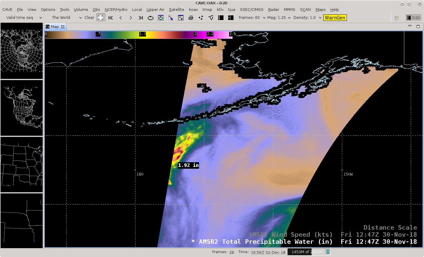
![GCOM-W1 AMSR2 Total Precipitable Water and Wind Speed products over the Aleutian Islands at 1247 UTC on 30 November [click to enlarge]](https://cimss.ssec.wisc.edu/satellite-blog/wp-content/uploads/sites/5/2018/11/181130_1247utc_gcomW1_amsr2_totalPrecipitableWater_windSpeed_Aleutians_anim.gif)
GCOM-W1 AMSR2 Total Precipitable Water and Wind Speed products over the Aleutian Islands at 1247 UTC on 30 November [click to enlarge]
A plume of
moisture and
strong winds ahead of a low pressure and cold front (
surface analysis) moving across the Aleutian Islands
(above).
Due to the frequent overlap of polar-orbiting satellite swaths at high latitudes, some locations can have data coverage from numerous consecutive overpasses. The example below shows the Barents Sea — between 70-80º N latitude — during 7 consecutive swaths from 2256 UTC on 28 November to 0847 UTC on 29 November.
![GCOM-W1 AMSR2 Total Precipitable Water and Wind Speed products over the Barents Sea from 2256 UTC on 28 November to 0847 UTC on 29 November [click to enlarge]](https://cimss.ssec.wisc.edu/satellite-blog/wp-content/uploads/sites/5/2018/11/181128_181129_gcomW1_amsr2_totalPrecipitableWater_windSpeed_Barents_Sea_anim.gif)
GCOM-W1 AMSR2 Total Precipitable Water and Wind Speed products over the Barents Sea from 2256 UTC on 28 November to 0847 UTC on 29 November [click to enlarge]
View only this post
Read Less


![Plot of 00 UTC Lincoln, Illinois rawinsonde data [click to enlarge]](https://cimss.ssec.wisc.edu/satellite-blog/wp-content/uploads/sites/5/2018/12/181201_18utc_181202_00utc_kilx_raobs_anim.gif)
![Terra/Aqua MODIS and Suomi NPP/NOAA-20 VIIRS Visible and Infrared images [click to enlarge]](https://cimss.ssec.wisc.edu/satellite-blog/wp-content/uploads/sites/5/2018/12/181201_modis_viirs_visible_infraredWindow_IL_anim.gif)
![Comparison of GOES-16 ABI and NOAA-20 VIIRS Infrared Window images at 2007 UTC [click to enlarge]](https://cimss.ssec.wisc.edu/satellite-blog/wp-content/uploads/sites/5/2018/12/181201_2007utc_goes16_abi_vs_noaa20_viirs_infrared_IL.png)
![GCOM-W! AMSR2 Total Precipitable Water and Wind Speed products, from 2256 UTC on 28 November to 1692 UTC on 30 November [click to play animation]](https://cimss.ssec.wisc.edu/satellite-blog/wp-content/uploads/sites/5/2018/11/181128_181130_amsr2_totalPrecipitableWater_windSpeed_global_anim.gif)
![Suomi NPP VIIRS True Color RGB image at 1753 UTC [click to enlarge]](https://cimss.ssec.wisc.edu/satellite-blog/wp-content/uploads/sites/5/2018/11/181129_1753utc_suomiNPP_viirs_truecolor_Argentina_anim.gif)
![Suomi NPP VIIRS True Color RGB and Infrared Windoe (11.45 µm) images at 1753 UTC [click to enlarge]](https://cimss.ssec.wisc.edu/satellite-blog/wp-content/uploads/sites/5/2018/11/181129_1753utc_suomiNPP_viirs_truecolor_infraredWindow_Argentina_anim.gif)
![NOAA-20 VIIRS True Color RGB and Infrared Windoe (11.45 µm) images at 1843 UTC [click to enlarge]](https://cimss.ssec.wisc.edu/satellite-blog/wp-content/uploads/sites/5/2018/11/181129_1843utc_noaa20_viirs_truecolor_infraredWindow_Argentina_anim.gif)

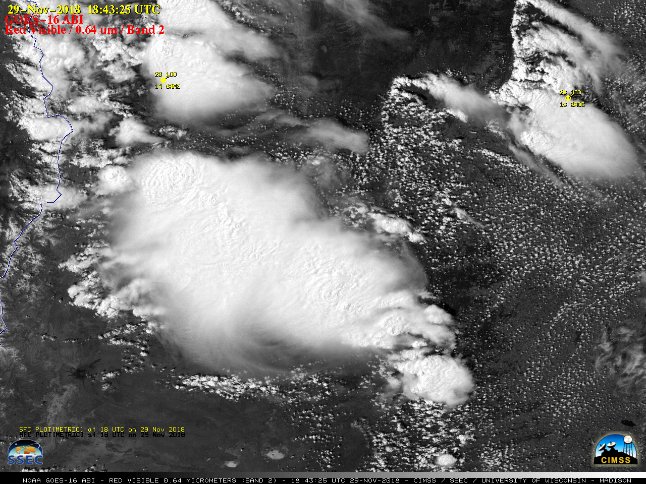
![GOES-16 Near-Infrared "Snow/Ice" (1.61 µm) images [click to play MP4 animation]](https://cimss.ssec.wisc.edu/satellite-blog/wp-content/uploads/sites/5/2018/11/G16_NIR_ARGENTINA_MCS_29NOV2018_2018333_184325_GOES-16_0001PANEL.GIF)
![GOES-16 "Clean" Infrared Window (10.3 µm) images [click to play MP4 animation]](https://cimss.ssec.wisc.edu/satellite-blog/wp-content/uploads/sites/5/2018/11/G16_IR_ARGENTINA_MCS_29NOV2018_2018333_184325_GOES-16_0001PANEL.GIF)
![GOES-16 "Red" Visible (0.64 µm, top), Near-Infrared :Snow/Ice" (1.61 µm, center) and "Clean" Infrared Window (10.3 µm, bottom) images [click to play MP4 animation]](https://cimss.ssec.wisc.edu/satellite-blog/wp-content/uploads/sites/5/2018/11/G16_VIS_NIR_IR_ARGENTINA_AACP_29NOV2018_2018333_214825_GOES-16_0003PANELS.GIF)
![Plot of 12 UTC Santa Rosa rawinsonde data [click to enlarge]](https://cimss.ssec.wisc.edu/satellite-blog/wp-content/uploads/sites/5/2018/11/181129_12UTC_SAZR_RAOB.GIF)
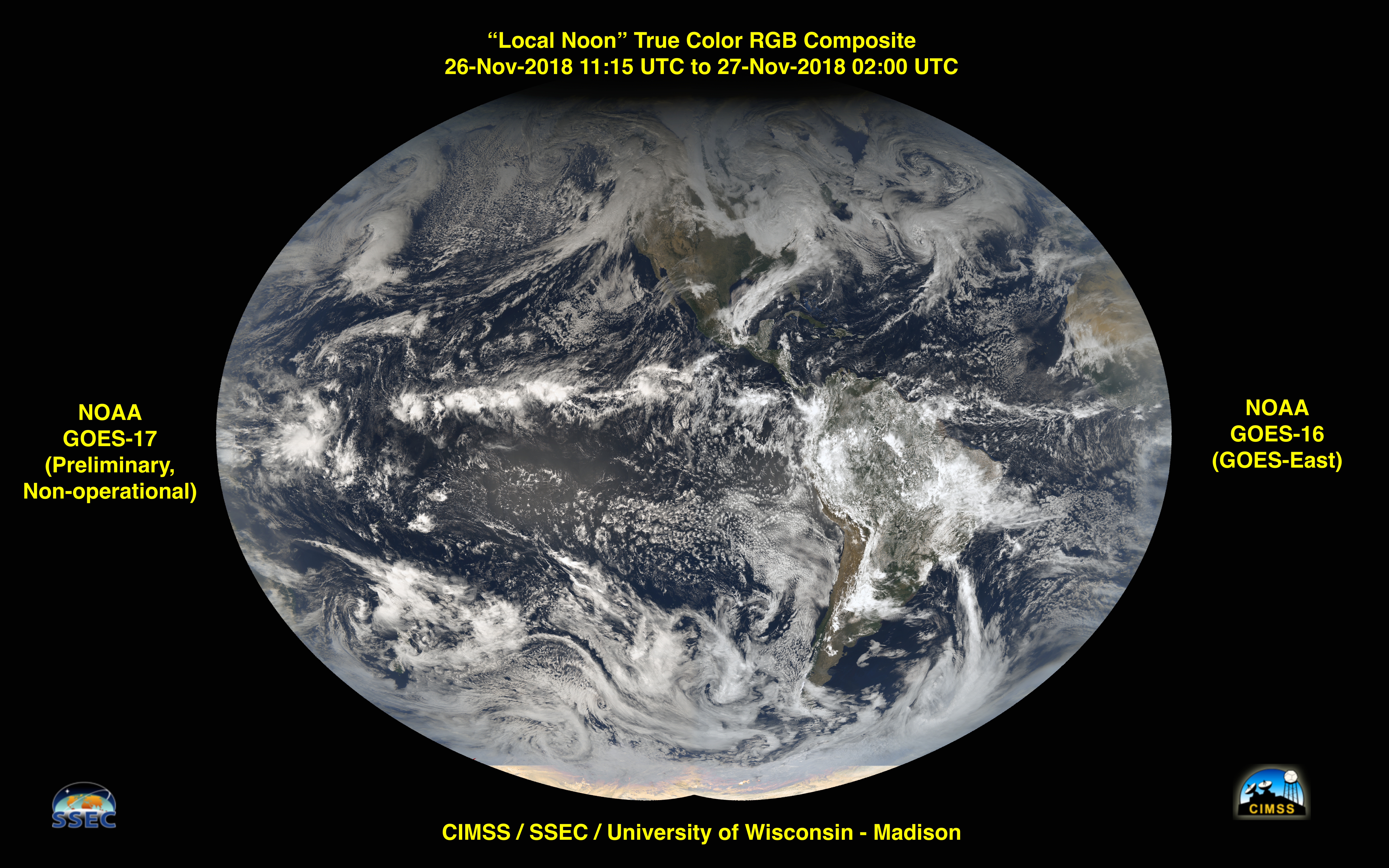
![GOES-17 / GOES-16 True Color RGB composite [click to enlarge]](https://cimss.ssec.wisc.edu/satellite-blog/wp-content/uploads/sites/5/2018/11/GOES17-GOES16-truecolor-local-noon-v2.jpg)
![GOES-17 / GOES-16 True Color RGB composite [click to enlarge]](https://cimss.ssec.wisc.edu/satellite-blog/wp-content/uploads/sites/5/2018/11/GOES17-GOES16-truecolor-local-noon-reference-v2.jpg)
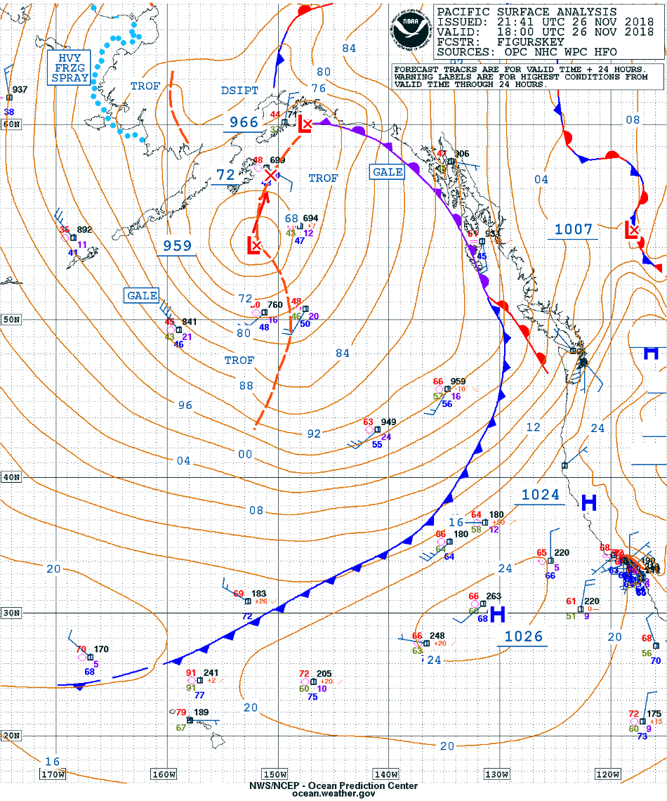
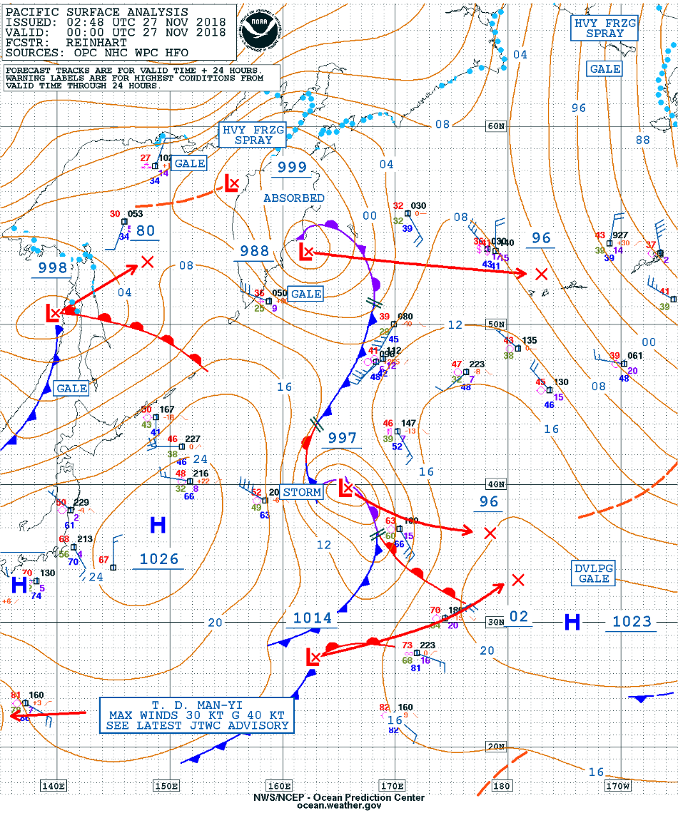
![Surface analyses from 12 UTC on 26 November to 00 UTC on 27 November [click to enlarge]](https://cimss.ssec.wisc.edu/satellite-blog/wp-content/uploads/sites/5/2018/11/181126_surface_analysis_anim.gif)

/na2018_12_01_335.gif)