This website works best with a newer web browser such as Chrome, Firefox, Safari or Microsoft Edge. Internet Explorer is not supported by this website.

Southeast US Tornado Outbreak, Northcentral US Blizzard

A very large and very intense mid-latitude cyclone was responsible for a major tornado outbreak in the southeastern US, as well as widespread blizzard conditions across the northcentral US on 01 March 2007. AWIPS images of the GOES water vapor channel (above;... Read More

AWIPS water vapor image

A very large and very intense mid-latitude cyclone was responsible for a major tornado outbreak in the southeastern US, as well as widespread blizzard conditions across the northcentral US on 01 March 2007. AWIPS images of the GOES water vapor channel (above; 48-image QuickTime animation) and the GOES 10.7 µm InfraRed (IR) channel (below; 48-image QuickTime animation) show the unusually large size of the storm during the 01-02 March period. Widespread reports of tornadoes, hail, and damaging winds were noted over much of the southeastern quarter of the US, including several fatal tornadoes (Caulfield, Missouri; Enterprise, Alabama; and Americus, Georgia — all rated EF3). A total of 31 tornadoes were reported, with 20 fatalities; hail was as large as 2.5 inches in diameter in parts of Missouri and Arkansas. The Storm Prediction Center issued a rare “High Risk” Convective Outlook early in the day, and eventually issued 3 Severe Thunderstorm Watches and 13 Tornado Watches during the prolonged severe weather event. Meanwhile, in the northcentral US, blizzard conditions were common across parts of North and South Dakota, Nebraska, Minnesota, and Iowa (US watches, warnings, and advisories) — several locations in that region reported snowfall totals of 15-21 inches, and many schools and highways across the region were closed due to the blowing and drifting snow.
AWIPS IR image

A closer look at the GOES-12 10.7 µm IR imagery (below; 100-image QuickTime animation) shows the cloud top temperature structure from 12:15 UTC on 01 March to 03:40 UTC on 02 March — GOES-12 was in Rapid Scan Operations, so images were available at 5-10 minute intervals during much of the period. There were no well-defined “enhanced-v” signatures evident on the IR images, but cold cloud top temperatures in the -60º to -70º C range (orange to red enhancement) were common; the coldest cloud top temperature noted on the GOES-12 IR imagery was -76 C at 19:15 UTC (green enhancement), which was around the time of the Enterprise, Alabama tornado (which caused 8 fatalities when it struck a high school). Radar images of the Enterprise tornado can be seen on the NWS Tallahasse site and the  Weather Underground WunderBlog. Vertical wind shear was enhanced over the southeastern US by strong winds in the middle to upper troposphere associated with an approaching jet streak — this helped to create an environment favorable for the development of rotating updrafts and supercell thunderstorms.
GOES-12 10.7µm IR image

View only this post Read Less

More blowing dust in Texas

Another case of blowing dust was noted across the southern Texas panhandle region on 01 March 2007. Unlike the stronger blowing dust event in that same area 5 days earlier (on 24 February), there was no distinct dust cloud feature evident on... Read More

GOES-11 IR difference image / GOES-12 visible image

Another case of blowing dust was noted across the southern Texas panhandle region on 01 March 2007. Unlike the stronger blowing dust event in that same area 5 days earlier (on 24 February), there was no distinct dust cloud feature evident on the GOES-12  visible channel imagery (above, right) — however, an IR difference product using the 10.7 µm and 12.0 µm channels available on GOES-11  did reveal a subtle “dark blowing dust signature” (above, left; Java animation). No surface stations in the area reported blowing dust during the time period shown; visibilities did drop to 2-4 miles at Big Spring TX (station identifier KBPG), but remained at 9-10 miles at San Angelo TX (station identifier KSJT).

.
A color-enhanced version of the GOES-11 IR difference product or “split window difference” (below) shows that this “dust signature” occurs when the difference between the 10.7 µm and 12.0 µm brightness temperatures is in the -1º K to -2º K range (yellow enhancement). Note that there is also a “false dust signal” farther to the west over regions of higher albedo soil — but the “dust signature” would propagate in the direction of the boundary layer wind flow (in this case, toward the southeast) on an image animation, while the “false signal” would remain stationary. The 12.0 µm IR channel is not available on GOES-12, having been replaced by a 13.3 µm IR channel that is used for better cloud top height assignment; however, the 12.0 µm IR channel is available on the polar-orbiting MODIS and AVHRR instruments, which is useful for the detection of airborne dust and volcanic ash.
GOES-11 IR difference image

View only this post Read Less

February 2007: A month of Northern Hemisphere water vapor channel images

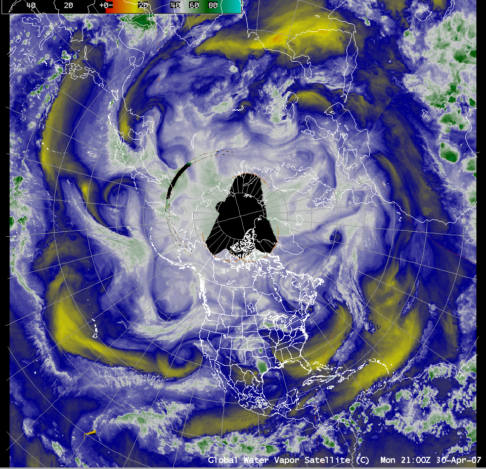
An animation of 3-hourly water vapor channel image composites from AWIPS during the entire month of February 2007 (35 MB QuickTime animation; 1280×1024 screen resolution required) shows the diverse variety of storms that affected the Northern Hemisphere during that particular month.... Read More

AWIPS northern hemisphere water vapor image

An animation of 3-hourly water vapor channel image composites from AWIPS during the entire month of February 2007 (35 MB QuickTime animation; 1280×1024 screen resolution required) shows the diverse variety of storms that affected the Northern Hemisphere during that particular month. Significant weather events in the US included fatal tornadoes in central Florida (02 February) and New Orleans (13 February), heavy lake-effect snow in western New York (141 inches in 10 days at Redfield, 03-12 February), and winter storms affecting much of the eastern US (13-14 February) and the northcentral US and Great Lakes (24-26 February). February 2007 ended up being unusually cold and snowy across much of the Upper Midwest and Great Lakes regions — Grand Rapids, Michigan and Rochester, Minnesota had their snowiest February on record (33.6 inches and 19.6 inches, respectively), and La Crosse, Wisconsin experienced their greatest storm total snowfall on record (21.0 inches from 23-25 February).

View only this post Read Less

Hail damage to Space Shuttle external fuel tanks

An isolated thunderstorm developed over east-central Florida and moved over the Kennedy Space Center during the late afternoon on 26 February 2007, producing golf ball size hail (2.0 inches in diameter) and wind gusts as high as 72 mph (SPC storm reports). This hail produced damage to the external fuel tanks of the Space... Read More

GOES-12 10.7µm IR image

An isolated thunderstorm developed over east-central Florida and moved over the Kennedy Space Center during the late afternoon on 26 February 2007, producing golf ball size hail (2.0 inches in diameter) and wind gusts as high as 72 mph (SPC storm reports). This hail produced damage to the external fuel tanks of the Space Shuttle Atlantis, which was on the launch pad undergoing preparations for a 15 March 2007 launch. This particular convective cell was relatively compact and formed rather quickly, and exhibited cloud top temperatures between -50 to -60º C (orange to red enhancement) on GOES-12 10.7µm InfraRed (IR) imagery (above; Java animation).

A comparison of 4-km resolution GOES-12 IR imagery with the corresponding 1-km resolution NOAA-15 AVHRR IR image (below) shows that more accurate (and significantly colder) cloud top temperatures can be detected using satellite instruments with better spatial resolution. Note the distinct “overshooting top” region with a minimum brightness temperature of -65º C (dark red enhancement) on the 21:50 UTC NOAA-15 image, versus cloud top temperature values that were only as cold as -54º C (orange enhancement) on the 21:45 UTC GOES-12 image (these two IR images were about 20-25 minutes prior to the time of the reported hail damage). The Advanced Baseline Imager (ABI) instrument on GOES-R (scheduled for launch in 2014) will have IR channels with a spatial resolution of 2 km, which should improve cloud top temperature detection capabilities over the current GOES imager IR channels.
NOAA-15 / GOES-12 IR image comparison

View only this post Read Less