![Suomi NPP VIIRS Day/Night Band (0.7 µm) and Infrared Window (11.45 µm) images, with SPC storm reports of hail and wind damage [click to enlarge]](https://cimss.ssec.wisc.edu/satellite-blog/wp-content/uploads/sites/5/2017/06/170611_0734utc_suomi_npp_viirs_dnb_infrared_SD_mcs_anim.gif)
Suomi NPP VIIRS Day/Night Band (0.7 µm) and Infrared Window (11.45 µm) images, with SPC storm reports of hail and wind damage [click to enlarge]
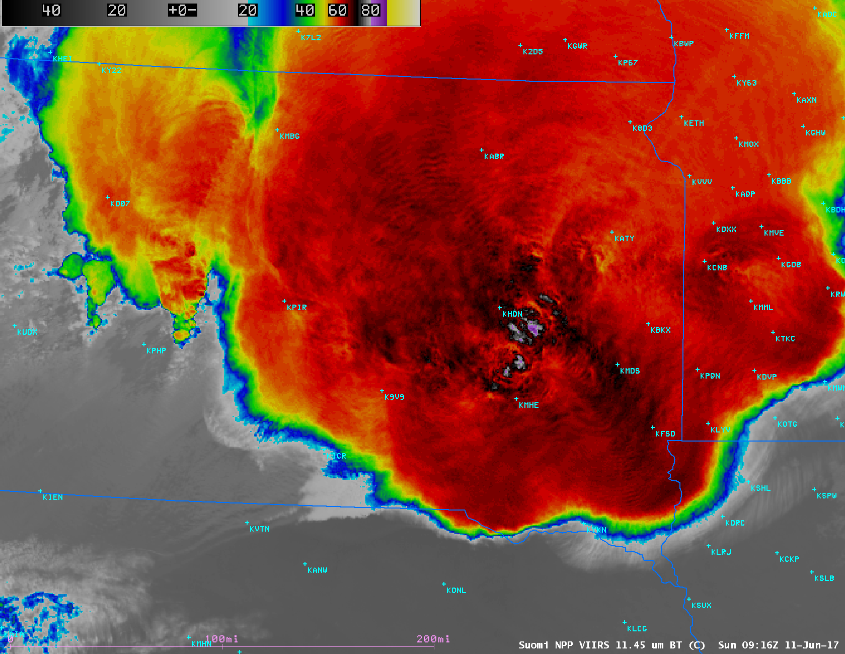
A large Mesoscale Convective System (MCS) developed and intensified over western South Dakota during the nighttime hours of
10 June –
11 June 2017, evolving into a bow echo that spread a swath of hail and strong winds from central/eastern South Dakota across Minnesota and into Wisconsin and Michigan (SPC storm reports:
10 June |
11 June). Image toggles between Suomi NPP VIIRS Day/Night Band (0.7 µm) and Infrared Window (11.45 µm) at 0734 UTC or 2:34 am Central Time
(above) and 0916 UTC or 4:16 am Central Time
(below) showed numerous well-defined overshooting tops and cloud-top gravity waves over South Dakota. The coldest cloud-top infrared brightness temperature on the 0916 UTC image was -88º C
(dark violet color enhancement). Since the Moon was in the Waning Gibbous phase (at 97% of Full), its ample illumination provided vivid examples of the “visible image at night” capability of the Day/Night Band; several bright white “lightning streaks” were also evident, a signature of cloud top illumination by intense lightning activity.
![Suomi NPP VIIRS Day/Night Band (0.7 µm) and Infrared Window (11.45 µm) images, with SPC storm reports of hail and wind damage [click to enlarge]](https://cimss.ssec.wisc.edu/satellite-blog/wp-content/uploads/sites/5/2017/06/170611_0916utc_suomi_npp_viirs_dnb_infrared_SD_mcs_anim.gif)
Suomi NPP VIIRS Day/Night Band (0.7 µm) and Infrared Window (11.45 µm) images, with SPC storm reports of hail and wind damage [click to enlarge]
During the subsequent daytime hours of 11 June, GOES-16 Visible (
0.64 µm) and Infrared Window (
10.3 µm) images
(below) showed the eastward progression of the MCS across Minnesota into western Wisconsin.
![GOES-16 Visible (0.64 µm, top) and Infrared Window (10.3 µm, bottom), with SPC storm reports of hail and wind plotted in yellow [click to play animation]](https://cimss.ssec.wisc.edu/satellite-blog/wp-content/uploads/sites/5/2017/06/G16_VIS_IR_MN_WI_SPC_11JUN2017_480x1280_B213_2017162_124718_0002PANELS.GIF)
GOES-16 Visible (0.64 µm, top) and Infrared Window (10.3 µm, bottom), with SPC storm reports of hail and wind plotted in yellow [click to play animation]
** GOES-16 data posted on this page are preliminary, non-operational data and are undergoing testing **