Himawari-8 AHI Visible (0.64 µm) and Infrared Window (10.4 µm) images (below; also available as a large 31-Mbyte animated GIF) revealed the formation of a well-defined eye during the day.
Nighttime images of Suomi NPP VIIRS Day/Night Band (0.7 µm) and Infrared Window (11.45 µm) data at 1859 UTC (below, courtesy of William Straka, SSEC) showed the ragged appearance of the eye at that time, with an isolated convective burst that had developed well west of the eye.
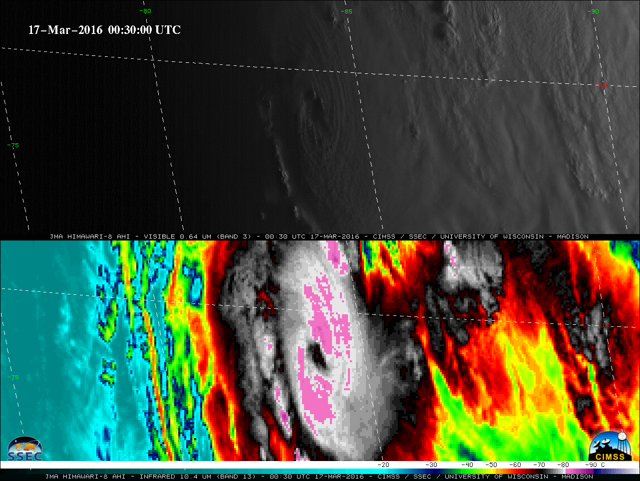
Severe Cyclone Emeraude in the Indian Ocean
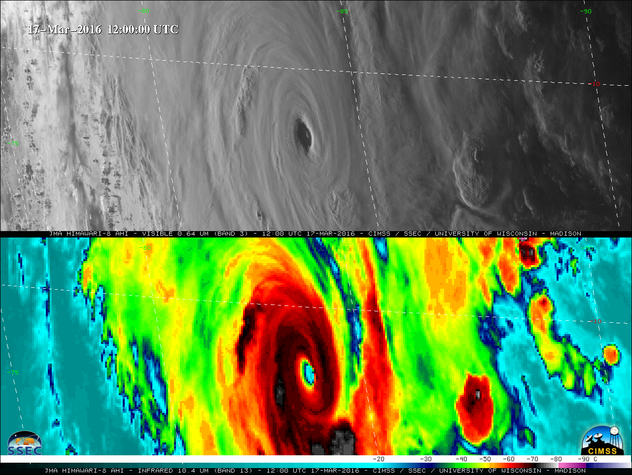
March 17th, 2016 | Scott BachmeierStrong storm over the Upper Midwest and western Great Lakes
March 16th, 2016 | Scott BachmeierA closer view of GOES-13 Visible (0.63 µm) images with METAR surface reports (below) revealed the strong winds caused by the tight pressure gradient — a peak wind gust of 61 mph was recorded at Waukesha in southeastern Wisconsin, with multiple power outages across the region caused by wind-related tree damage. Heavy rain (as much as 2-3 inches) produced some minor river flooding in various parts of Wisconsin; across northern Wisconsin, northeastern Minnesota, and the Upper Peninsula of Michigan the rain changed to snow, with as much as 18.5 inches accumulating at Redridge, Michigan, 13.0 inches at Lutsen, Minnesota, and 8.0 inches at Poplar and Sand Bay, Wisconsin. The weight of the wet snow was causing tree limbs to fall, with additional power outages being reported.
With the strong winds associated with this storm, there were also scattered pilot reports of moderate turbulence across the region, including 2 reports of severe turbulence over southern Wisconsin as seen below.Moderate to severe turbulence over the Midwest
March 11th, 2016 | Scott BachmeierThe transverse banding cloud filaments showed up with a bit more clarity on a 1-km resolution Aqua MODIS Water Vapor (6.7 µm) image at 1919 UTC (below).
A MODIS Cirrus (1.4 µm) image at 1738 UTC (below) was also a very effective tool for helping to visualize the transverse banding cloud filaments. A Turbulence SIGMET had been issued at 1433 UTC for much of the region, due to wind shear associated with jet steam aloft. Many of the pilot reports were noted to be Clear Air Turbulence (CAT), with one describing the severe turbulence encounter as “one jolt“. It can be seen from the GFS model isotachs of Maximum Wind that the reports of turbulence occurred within the entrance region of a curved jet stream segment, which are areas that favor the development of strong vertical and horizontal wind shear responsible for turbulence.![Terra MODIS "Cirrus" (1.38 µm) image with Turbulence SIGMET, Pilot Reports of turbulence, and GFS Max Wind isotachs [click to enlarge]](http://cimss.ssec.wisc.edu/satellite-blog/wp-content/uploads/2016/03/160311_1738utc_modis_cirrus_sigmet_pireps_gfs_maxwinds_anim.gif)
Terra MODIS “Cirrus” (1.38 µm) image with Turbulence SIGMET, Pilot Reports of turbulence, and GFS Max Wind isotachs [click to enlarge]
![Aqua MODIS Visible (0.65 µm), Infrared Window (11.0 µm), and Cirrus (1.38 µm) images, with Pilot Reports of turbulence [click to enlarge]](http://cimss.ssec.wisc.edu/satellite-blog/wp-content/uploads/2016/03/160311_1919utc_modis_visible_infrared_cirrus_pireps_anim.gif)
Aqua MODIS Visible (0.65 µm), Infrared Window (11.0 µm), and Cirrus (1.38 µm) images, with Pilot Reports of turbulence [click to enlarge]
@CIMSS_Satellite Looks like a nasty turbulence environment today over the Midwest. Lots of urgent PIREPs & SIGMET pic.twitter.com/pc8PU5xsXf
— Scott Dennstaedt (@AvWxWorkshops) March 11, 2016
Solar eclipse shadow as seen from geostationary satellites
March 9th, 2016 | Scott BachmeierToward the end of the eclipse, the shadow was also seen with NOAA GOES-15 (below) as it moved northwest and north of Hawai’i. In addition, the eclipse shadow was captured with the Chinese satellites FY-2E and FY-2G (below).