The corresponding daily time series plots of surface weather data at Beijing Capital International Airport (below) revealed that the surface visibility remained below 1.0 statute miles for extended periods. Although not indicated on the 26 November plot, the surface visibility began at 19 statute miles on that day, before the wind speeds became 4 knots or less beginning at 10 UTC and the visibility eventually began to decrease.
Smog and poor air quality in Beijing, China
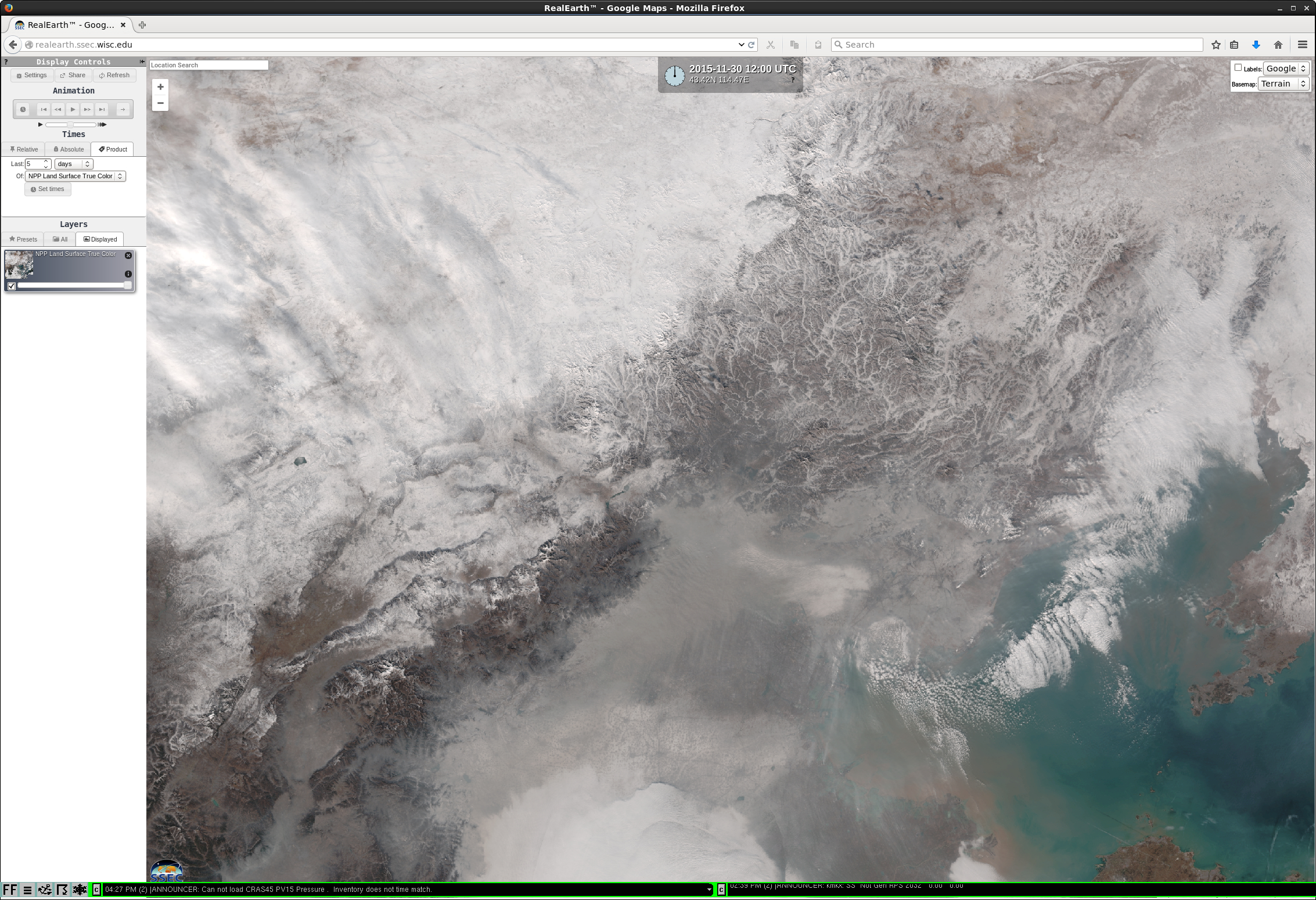
November 30th, 2015 | Scott BachmeierIce growth in Hudson Bay
November 24th, 2015 | Scott BachmeierA better view of the offshore ice (as well as the ice in central Hudson Bay, northeast of the aforementioned mesoscale low) was provided by Suomi NPP VIIRS true-color and false-color images, visulized using the SSEC RealEarth web map server (below). In the false-color image, snow cover and ice appear as darker shades of cyan.
A comparison of Canadian Ice Service analyses from 16 November and 23 November (below) showed the growth of the offshore ice along the western and northwestern edges of Hudson Bay, as well as the larger area of ice growing southward in the central portion of Hudson Bay during that 1-week period. The departure from normal images at the bottom indicated that ice concentration along the western and northwestern edges was well below normal (red), while the concentration of the large area of ice in central Hudson Bay was greater than normal (blue).GOES-13 Sounder Anomalies
November 23rd, 2015 | Scott Lindstrom![GOES-15 Visible (0.63 µm) images [click to play animation]](https://cimss.ssec.wisc.edu/satellite-blog/wp-content/uploads/sites/5/2015/11/GOES13SNDR_0847_0947toggle.gif)
GOES-13 Sounder Band 5 Infrared (13.4 µm) images, 0847 and 0947 UTC on 20 November [click to enlarge]
*Update #2: * **Effective immediately; all the GOES-13 (GOES-East)
sounding products are ceased to produce and stop distribution as we are
experiencing an anomaly with the sounder instrument. Engineers are
investigating the problem. We will inform you when we resume our normal
operations.*Update #1: * GOES-13 (GOES-East) Sounder IR Data Outage
*Topic:* GOES-13 (GOES-East) Sounder IR Data Products Outage
*Date/Time**Issued:*November 20, 2015 1955Z*
**Product(s) or Data Impacted:*
GOES-13 (GOES-East) Sounder data
Blended Hydrometorological Products – Blended TPW
Microwave AWIPS Products – Blended TPW
Microwave McIDAS Products – Blended TPW
GOES Gridded Cloud Product
GOES VARiable data
AFEP/Ingestor – GOES
N-AWIPS Ingest
Single Field of View BUFR
Single Field of View SDPI for AWIPS
Single Field of View TPW
Sounding ASOS SCSP
Web Pages*Date/Time of Initial Impact:*November 20, 2015 0922Z **
*Date/Time of Expected End:* TBD
*Length of Outage:* TBD
*Details/Specifics of Change:*GOES-13 (GOES-East) Sounder instrumentis experiencing an anomaly. Engineers are investigating the problem. GOES-13 Sounder IR data is not available. **Effective immediately all the GOES-13 (GOES-East) sounding products are ceased to produce and stop distribution as we are experiencing an anomaly with the sounder instrument. Engineers are investigating the problem. We will inform you when we will resume our normal operations.
==================================================================
Update 19 January 2016
==================================================================
GOES-14 is scheduled to broadcast 1-minute SRSO-R data starting 1 February. GOES-14 will be activated on 25 January, with a maneuver shortly thereafter. It is likely that GOES-14 Sounder data will be broadcast from 1-25 February (GOES-14 Sounder Timing will be adjusted to match GOES-13 Sounder Timing) when the GOES-14 Imager is broadcasting SRSO-R data.