Hurricane Ike
Hurricane Ike intensified into a Category 4 storm late in the day on 03 September 2008. A comparison of GOES-12 10.7 µm IR and SSM/IS 85 GHz microwave images from the CIMSS Tropical Cyclones site (above) showed a... Read More
Hurricane Ike intensified into a Category 4 storm late in the day on 03 September 2008. A comparison of GOES-12 10.7 µm IR and SSM/IS 85 GHz microwave images from the CIMSS Tropical Cyclones site (above) showed a... Read More
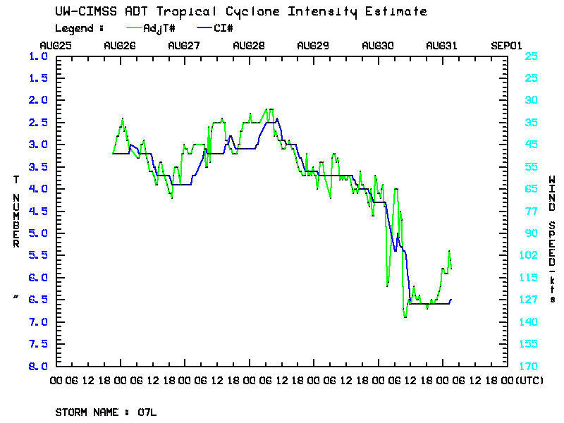
Hurricane Gustav underwent a period of rapid intensification during the daytime hours on 30 August 2008 (as seen on a plot of the CIMSS Advanced Dvorak Technique), reaching Category 4 intensity. AWIPS images of the GOES-12 10.7 µm IR channel (above) revealed an impressive eye structure on 30 August,... Read More
Hurricane Gustav rapidly intensified into a hurricane on 26 August 2008 (less than 24 hours after the first advisory was issued). As noted by the National Hurricane Center’s Gustav discussion number 6:HURRICANE GUSTAV DISCUSSION NUMBERÂ Â 6 NWS TPC/NATIONAL HURRICANE CENTER MIAMI FLÂ Â AL072008 1100... Read More
Parts of interior Alaska experienced heavy rainfall and significant river flooding during the last week of July 2008; AWIPSÂ composite images of the GOES-11 and GOES-12 water vapor channels (above) showed a rather unusual moisture plume — one having a long northwesterly fetch — stretching from the Russian arctic coast... Read More
