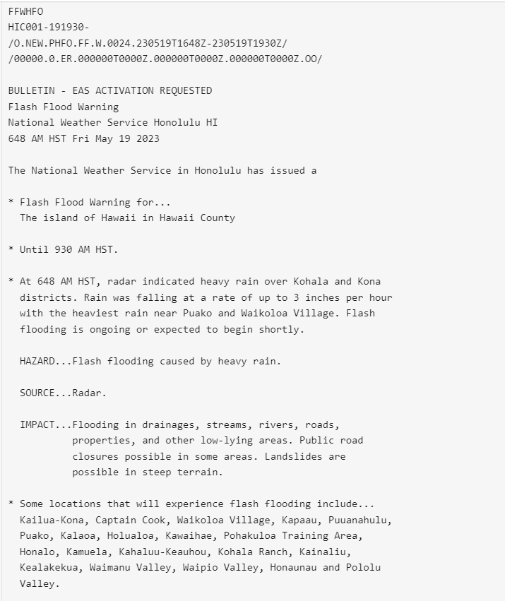
This website works best with a newer web browser such as Chrome, Firefox, Safari or Microsoft Edge. Internet Explorer is not supported by this website.

Category: NOAA-20

Calf Canyon Fire produces a pyrocumulonimbus cloud

1-minute Mesoscale Domain Sector GOES-16 (GOES-East) “Red” Visible (0.64 µm), Shortwave Infrared (3.9 µm), “Clean” Infrared Window (10.35 µm) and Cloud Top Temperature derived product images (above) showed that the northern portion of the Calf Canyon Fire/Hermits Peak Fire in New Mexico produced a pyrocumulonimbus (pyroCb) cloud on 10 May 2022. Extreme fire behavior was aided by surface wind gusts in the 42-64 mph... Read More

Hail in Portland OR

Here’s a text received late on 8 May from a kid: “Hail today in Portland”. The animation above shows GOES-17 Visible (0.64 µm) imagery between 2201 UTC on 8 May and 0311 UTC on 9 May. The follow-up text answering the obvious question (What time?) was “Around 5 PM” —... Read More

First thunderstorm of the season in the Anchorage, Alaska area

First thunderstorms of the year around here. @DaveSnider @capture907 @AlaskaWx pic.twitter.com/xeMhNiLSiU— Brian Brettschneider (@Climatologist49) May 5, 2022 1-minute Mesoscale Domain Sector GOES-17 (GOES-West) “Red” Visible (0.64 µm) images (above) showed these isolated thunderstorms as they moved north-northwestward up the Susitna Valley (northwest of Anchorage).In the corresponding 1-minute GOES-17 “Clean” Infrared Window... Read More