Rare Lake Effect Snow in Central Indiana
While much of the weather world on 23 February 2026 has turned its eyes to the east coast of the United States due to the presence of a strong bomb cyclone and an associated blizzard in the most densely-populated region of the country, the effects of this event are being felt much further out. One of the more unexpected impacts is the presence of lake effect snow in the northern part of central Indiana, nearly a hundred miles from the shore of Lake Michigan.
The impact of the Great Lakes on snowfall totals is well-known. Generally westerly flow across the Great Lakes causes higher snow totals on the eastern edges of those lakes to have notably higher annual snowfall totals. This is because the (relatively) warm and moist lakes inject sensible and latent heat into air that passes over the lakes. Those air masses then increased surface friction and terrain once they reach the shore, factors which cause low-level convergence and orographic lift which combine to help increase the low-level snowfall formation process. A map is available here from our friends at NOAA’s Great Lakes Environmental Research Laboratory; note how the downstream side of each of the Great Lakes hosts a local maximum in annual snowfall.
But what happens when the wind pattern isn’t the standard west-to-east flow that we see throughout much of the year?
The 700 hPa map from 1200 UTC on the 23rd gives an easily accessible overview of the synoptic state of the atmosphere on this day. The obvious weather maker is the cyclone off of the east coast of the continental United States, with a broad ridge across the western US. Over the Great Lakes, flow is almost due northerly.

The northerly flow across the Great Lakes is forcing lake effect snows in places that don’t always receive them. In particular, the fetch across Lake Michigan runs nearly the entire north-south extent of the lake. This puts a substantial plume of lake effect snow into northern and north-central Indiana. We’ll start our analysis with a true color view from the GOES-19 ABI as shown by SSEC’s Real Earth. The telltale signs of lake effect snow are present as narrow parallel bands of cloudiness forming over the lake, extending over the shore and penetrating into the land. But instead of the east-southeast orientation that is typical for Lake Michigan, the bands are almost straight north-south.

The Day Microphysics RGB can provide some insight to the makeup of the clouds producing these snows. The central band of cloudiness extending southward from Lake Michigan shows a lavender center where the clouds are geometrically thicker and a yellowish-green edge where they are thinner. Both of thse colors are associated with liquid clouds in this RGB, with the pinker colors representing clouds with larger water droplets. This is consistent with lake effect snow, as these clouds are much more shallow and closer to the surface than synoptically-forced clouds and thus are likely to be too warm to be purely ice clouds.

The Cloud Phase RGB similarly depicts a salmon-colored band where the clouds are liquid and have larger water particles, both of which are consistent with lake effect snowfall.

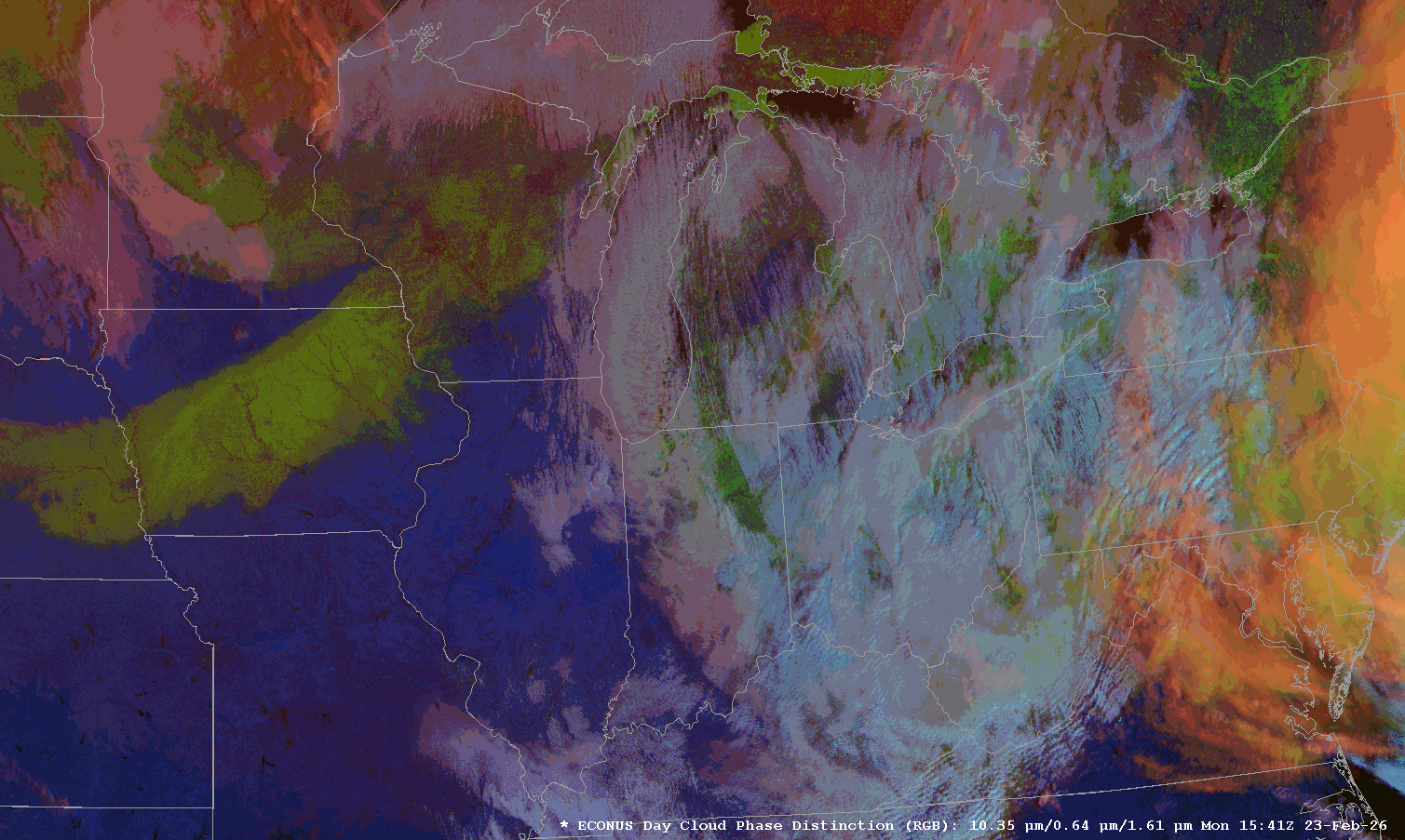
The Day Cloud Phase Distinction RGB also provides a unique perspective on the evolution of this event. Here, snow covered grown shows up s a bright green color. The wide swath of snow from last week’s event is clearly visible stretching from eastern Nebraska into north-central Wisconsin, for example. However, you can also see the surface snow cover in Indiana between the individual clouds of the lake-induced convection. The green and orange clouds assoicated with the thick ice clouds of the east coast cyclone are also visible on the far eastern edge of the image.
Finally, here is the 0.64 micron (red) visible satellite product with the Warsaw, Indiana NWS NEXRAD radar overlaid on top ot if, along with the surface weather conditions. The finer horizontal resolution of the 0.64 micron imagery really shows how small individual convective elements in a lake effect event can be. Persistent northerly winds ensures a constant flow of moisture and snow into the central part of Indiana. Based on this view, there’s clear lake effect influence as far south as Kokomo, meaning that town is hardly a tropical getaway today.

However, lake effect events are notoriously shallow. It is likely that the lake effect snow is propagating even further to the south, but after it reaches a certain distance away from the radar, the angled radar beam is overshooting the top of the snow rendering it invisible to that radar. If you also include the radar from the more southerly Indianapolis office, you can see individual lake effect precipitation echos penetrating as far south as the northern suburbs of Indianapolis, over 120 miles away from the Lake Michigan shore.

Lake effect events in northern Indiana aren’t altogether rare. South Bend, Indiana, and Joliet, Illinois are two cities at similar latitudes and similar distances away from Lake Michigan. However, South Bend’s position downstream of the lake contributes to its much higher snowfall of nearly 65 inches a year compared to Joliet’s annual snowfall of only 16 inches. However, the inland penetration of today’s event is certainly unusual, thanks to a stronger than normal flow over Lake Michigan that is almost perfectly oriented to maximize the influence that this lake can have on the regional weather.