Heat burst in eastern Colorado and western Kansas

MODIS 3.7 µm shortwave IR, 11.0 µm IR, and Land Surface Temperature product
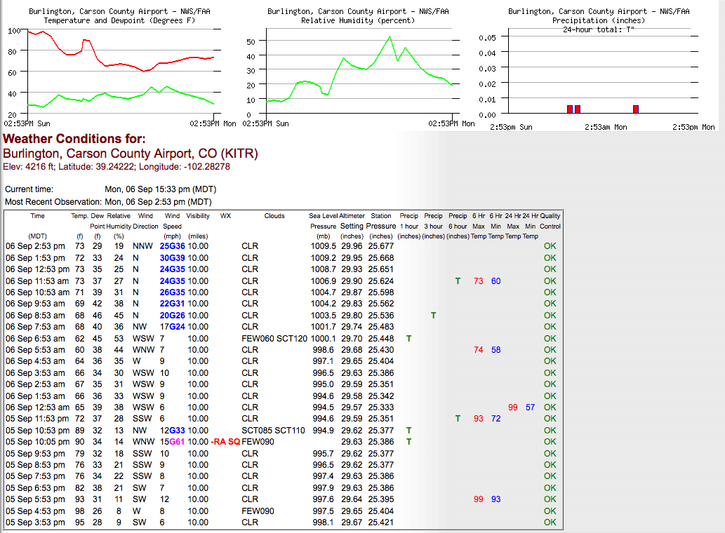
As noted on the AccuWeather WeatherMatrix blog, some locations in far eastern Colorado and far western Kansas experienced a “heat burst” as dry convection passed across the region overnight. AWIPS images of the 04:35 UTC (10:35 pm local time) MODIS 3.7 µm shortwave IR, MODIS 11.0 µm IR, and MODIS Land Surface Temperature (LST) product (above) revealed the isolated pocket of warm temperatures (darker orange color enhancement: as high as 24º C / 75.2º F on the shortwave IR image, 21.5º C / 70.7º F on the IR image, and 25.4º C / 78.7º F on the LST product) just northwest of Burlington, Colorado (station identifier KITR), in the wake of the passing convection (which exhibited cloud top IR brightness temperatures as cold as -36º C, darker blue color enhancement). Around the time of the MODIS images, the surface air temperature at Burlington had abruptly risen to 89º F / 32º C with wind gusts to 53 knots (61 mph).
A comparison of the 1-km resolution MODIS 11.0 µm IR image with the corresponding 4-km resolution GOES-13 10.7 µm R image (below) demonstrated the dramatic improvement in feature detection with higher spatial resolution. Parallax error associated with the high viewing angle of the geostationary GOES-13 satellite was also obvious in the image comparison.

MODIS 11.0 µm IR and GOES-13 10.7 µm IR images
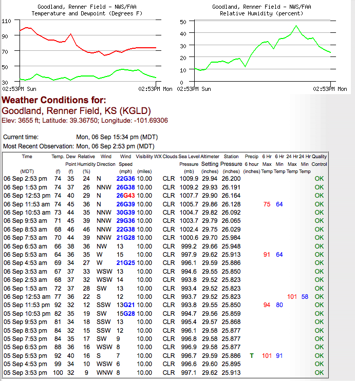
An animation of the GOES-13 10.7 µm IR images (below) showed the warm heat burst signature (the pocket of darker orange colors) migrating eastward into western Kansas, where the surface air temperature at Goodland (station identifier KGLD) later rose to 92º F / 33º C at 06:00 UTC (Midnight local time). Note that there no cloud-to-ground lightning strikes associated with the convection that produced the heat burst.

GOES-13 10.7 µm IR images
The heat burst signature was even evident on the 10-km resolution GOES-13 sounder Skin Temperature derived product image (below), with a maximum skin temperature value of 21.5º C / 70.7º F just to the northwest of Burlington, Colorado at 05:00 UTC (11:00 pm local time).

GOES-13 sounder Skin Temperature derived product image
Another example of a heat burst signature on satellite imagery can be seen in this case at Amarillo, Texas in June 2002.