Convection Returns to the southern Plains
Spring convection and associated severe weather returned to the southern Plains on April 22nd. Did predictors of convection do a good job in locating the severe cells?
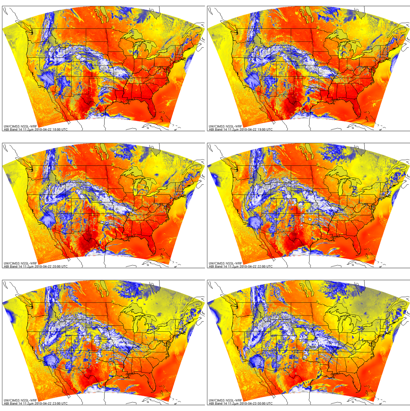
CIMSS has recently started to produce synthetic satellite imagery from the Weather Research and Forecasting (WRF) model run at the National Severe Storms Laboratory (NSSL). Output from daily runs at 00 UTC is produced for 9 infrared bands that correspond to those of the Advanced Baseline Imager (ABI) that will fly on GOES-R. The hourly loop of the 11.2-micrometer channel, above, for the period between 1800 UTC 22 April and 00 UTC 23 April, shows convection initially forming along the dryline in the Texas Panhandle between 1900 and 2000 UTC before progessing northeastward into Oklahoma and Kansas. Synthetic imagery of the middle of 3 ABI water vapor channels (6.95 microns), show a similar story. Model predictions give clues on where to look for convective development. How did real-time predictors of convective development perform?
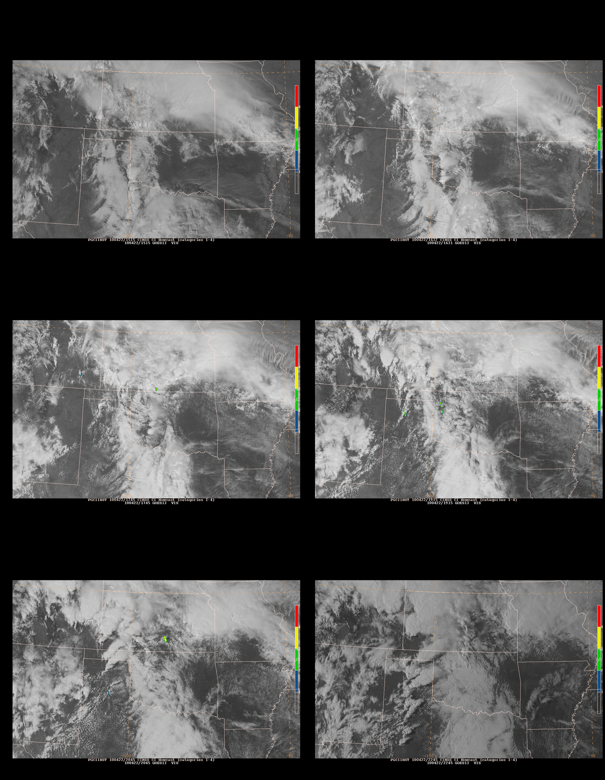
The UW Convective Initiation algorithm combines observations of 10.8-micron cooling (from GOES-13) with cloud phase changes. When cooling occurs as cloud phase is changing (suggesting growing cumulus towers that are glaciating), GOES-13 pixels are flagged as showing convective initiation. Depending on the cloud phase — all water, mixed water and ice, or all ice, the initiation is flagged in the screengrabs from N-AWIPS above as pre-CI cloud growth (blue), CI likely (green), or CI occurring (yellow). Once glaciation has occurred, CI detection turns off. A previous blog entry on this method is here.
UWCI does flag individual cells that subsequently develop, ignoring adjacent towering cumulus. Thus, it can draw forecaster attention to the updrafts that, for whatever reason, are the most vigorous. For example, the image at 1701 UTC show convective initiation indicated in one spot along the dryline in west Texas. By 1745 UTC, convection has developed. Shortly after 1800 UTC, UWCI identifies individual cells along a line from the extreme western portion of the Oklahoma panhandle northward into east central Colorado. These cells subsequently spawn severe weather. UWCI also flags nascent convective development for cells that eventually develop into an arc of convection over central Kansas at 2301 UTC. Note also that UWCI flags specific convective towers within a large cumulus field over the southern Panhandle. (Consider the three images at 2131 UTC and 2145 UTC and at 2231 UTC; convection initiation flagged at the earlier two images develops most vigorously as shown in the final image). This can focus forecaster attention to the clouds that are growing most rapidly.
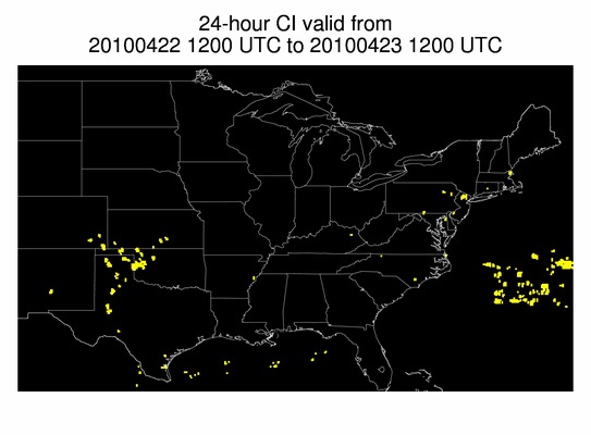
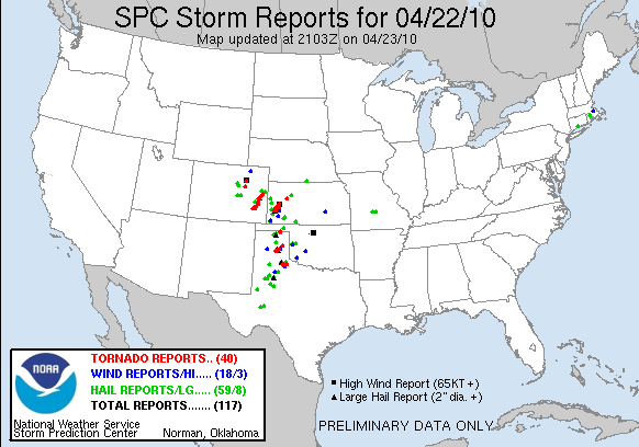
The two images above show where convective initiation was diagnosed to be ongoing at some time on 22 April, as well as a preliminary Storm Report from the Storm Prediction Center. Note the good general overlap of UWCI points over the High Plains and storm reports. That more Storm reports exist than UWCI points reflects the UWCI philosophy of keeping the false alarm rate low, perhaps at the expense of detection.
There are several UWCI hits over the northeast on 22 April as well. There, cold air at upper levels promoted self-destructing sunshine and shower and thunderstorm development. Clear skies early in the day (1431 UTC) gave way to cumuliform development. The strongest updrafts likely yield the strongest cloud-top-cooling signal (as shown in this loop) and evolve into the most vigorous shower or thundershower. Even though severe weather was not reported with these cells, lightning was produced, starting around 1900 UTC as shown here. Cloud-top cooling can give a forecaster a head’s up that a particular cell might become vigorous enough to electrify.
(Note: this post has been corrected to remove images from before 1645 UTC on 22 April that may have included mis-navigated regions of convective initiation).


