The “water vapor” channel: sometimes, it’s more like an IR channel
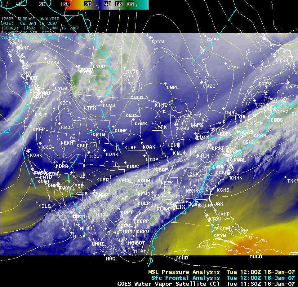
The most common interpretation of the GOES 6.5/6.7 µm “water vapor channel” imagery is that it provides a depiction of the “moisture content” of the middle to upper troposphere. While this is generally a valid interpretation, it is also important to keep in mind that first and foremost, the water vapor channel is essentially an InfraRed (IR) channel that senses the mean temperature of a layer of mid-tropospheric water vapor. The AWIPS GOES water vapor channel image on the morning of 16 January 2007 (above) provides a good example of the “temperature sensing characteristics” of this particular satellite channel. Bismarck, North Dakota (KBIS) was located within a continental arctic air mass that covered much of the central US (the KBIS surface air temperature at 12:00 UTC was -16º F / -27º C); on the other side of the cold front, Key West, Florida (KEYW) was located within a maritime tropical air mass (the KEYW surface air temperature at 12:00 UTC was +72º F / +22º C). Using the general rule of water vapor channel interpretation, “brighter” shades on the image (or with the color enhancement used here, the blue to white to green colors) are associated with a more moist middle troposphere, while “darker” shades (or the yellow to red colors on this enhancement) are associated with a drier middle troposphere (QuickTime animation of grayscale GOES-12 water vapor imagery). So was Bismarck (KBIS) more moist aloft than Key West (KEYW) at that time?
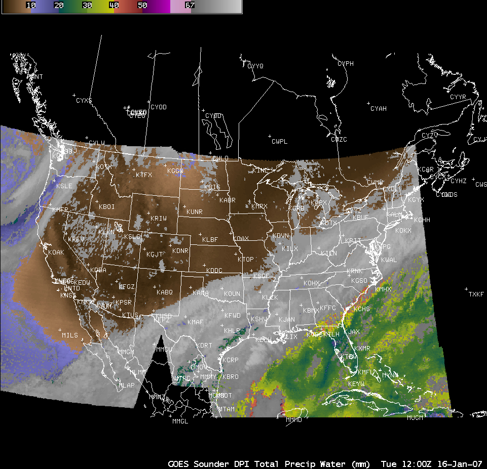
If we examine the GOES Sounder total precipitable water (PW) derived product (above) we see that in terms of moisture contained within the total atmospheric column, the air mass over KBIS is actually significantly drier (PW = 0.31 inches or 8 mm) than the air mass over KEYW (PW = 1.18 inches or 30 mm). However, the majority of the moisture that contributes to total column precipitable water is often contained within the lower troposphere, at altitudes below which is normally sensed by the GOES water vapor channel…so it’s not surprising that the 2 images above give us different answers regarding “moisture” at KBIS and KEYW.
Now let’s take a look at a vertical cross section of model-derived temperature and specific humidity, along a line from KBIS to KEYW (above). A plot of the GOES-12 water vapor channel weighting functions (derived using the rawinsonde data from KBIS and KEYW) indicates the altitude and vertical thickness of the “moist layer” that is being sensed by the satellite at each location — the height and thickness of this “layer” changes according to variations in air mass temperature/moisture distribution, as well as the actual satellite viewing angle (or “zenith angle”). It is interesting to note that despite very different air mass characteristics and satellite viewing angles (KBIS = cold and dry, zenith angle = 57.5º; KEYW = warm and moist, zenith angle = 29.5º), the water vapor channel weighting functions look very similar for those 2 locations — the altitude of the peak contribution is generally within the 400-500 hPa pressure range. The cross section above indicates that the specific humidity within that particular 400-500 hPa layer was generally between 0.2 and 0.5 g kg-1 at both KBIS and KEYW — however, note that the temperatures within that range of pressures were significantly colder at KBIS (-25º to -36º C) than at KEYW (-6º to -20º C). So assuming that the satellite was sensing similar values of mid-tropospheric moisture — specific humidity values between 0.2 and 0.5 g kg-1 — it is the temperature differences that contribute to the different water vapor “brightness temperatures” (and the resulting image brightness values or color shades) seen on the GOES water vapor image at those 2 locations.


