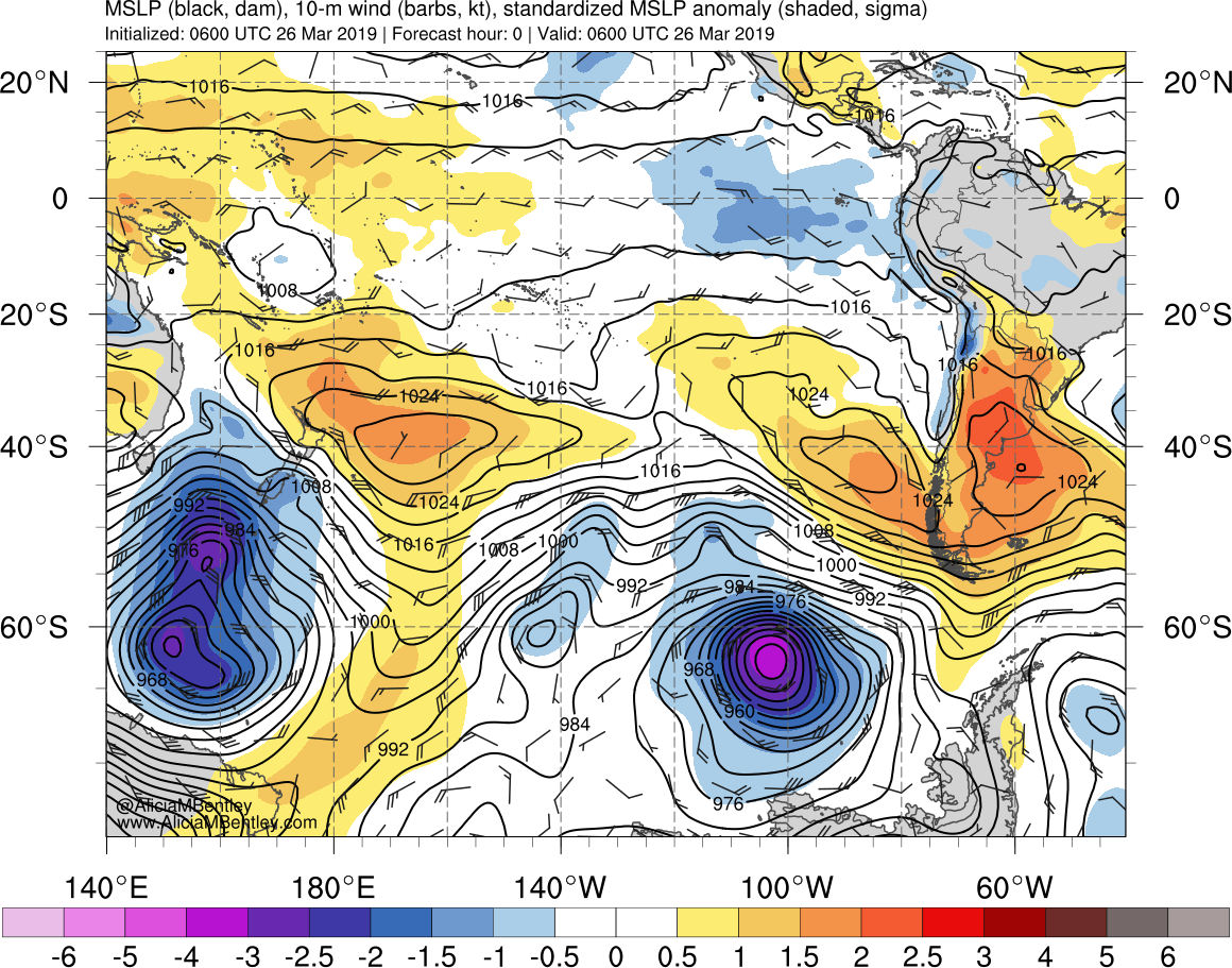
Strong cyclone near Antarctica
![Composites of geostationary and polar orbiter Infrared imagery [click to play animation]](https://cimss.ssec.wisc.edu/satellite-blog/wp-content/uploads/sites/5/2019/03/190325_infrared_composite_Antarctica_anim.gif)
Composites of geostationary and polar orbiter Infrared imagery [click to play animation]
![Composites of geostationary and polar orbiter Water Vapor imagery [click to play animation]](https://cimss.ssec.wisc.edu/satellite-blog/wp-content/uploads/sites/5/2019/03/190325_waterVapor_composite_Antarctica_anim.gif)
Composites of geostationary and polar orbiter Water Vapor imagery [click to play animation]
![GOES-16 Mid-level Water Vapor images [click to play animation | MP4]](https://cimss.ssec.wisc.edu/satellite-blog/wp-content/uploads/sites/5/2019/03/190325_goes16_waterVapor_South_Pacific_anim.gif)
GOES-16 Mid-level Water Vapor (6.9 µm) images [click to play animation | MP4]
![GOES-16 "Red" Visible (0.64 µm) images [click to play animation | MP4]](https://cimss.ssec.wisc.edu/satellite-blog/wp-content/uploads/sites/5/2019/03/190325_goes16_visible_South_Pacific_anim.gif)
GOES-16 “Red” Visible (0.64 µm) images [click to play animation | MP4]
![GOES-17 + GOES-16 True Color RGB image [click to enlarge]](https://cimss.ssec.wisc.edu/satellite-blog/wp-content/uploads/sites/5/2019/03/g16-g17-noon-composite-2019086.jpg)
GOES-17 + GOES-16 True Color RGB image [click to enlarge]
![Tiime series of surface observation data from AWS station 8930 Thurston Island [click to enlarge]](https://cimss.ssec.wisc.edu/satellite-blog/wp-content/uploads/sites/5/2019/03/190327_15z_8930_Thurston_Island_sfcmg_ant.GIF)
Time series of surface observation data from AWS station 8930 Thurston Island [click to enlarge]
![GOES-16 "Red" Visible (0.64 µm. left) and Low-level Water Vapor (7.3 µm, right) images [click to play animation | MP4]](https://cimss.ssec.wisc.edu/satellite-blog/wp-content/uploads/sites/5/2019/03/190326_goes16_visible_waterVapor_Peter_Island_anim.gif)
GOES-16 “Red” Visible (0.64 µm. left) and Low-level Water Vapor (7.3 µm, right) images [click to play animation | MP4]
![Landsat-8 False Color image [click to enlarge]](https://cimss.ssec.wisc.edu/satellite-blog/wp-content/uploads/sites/5/2019/03/190326_1456utc_landsat8_falsecolor_Peter_I_Island_anim.gif)
Landsat-8 False Color RGB image [click to enlarge]
![Suomi NPP VIIRS True Color RGB and Infrared Window (11.45 µm) images 1t 19 UTC and 21 UTC [click to enlarge]](https://cimss.ssec.wisc.edu/satellite-blog/wp-content/uploads/sites/5/2019/03/190326_suomiNPP_viirs_truecolor_infraredWindow_South_Pacific_anim.gif)
Suomi NPP VIIRS True Color RGB and Infrared Window (11.45 µm) images at 19 UTC and 21 UTC [click to enlarge]
#GOESWest is watching a hurricane-force low that’s headed toward the Antarctic Peninsula. This loop uses what’s known as Air Mass RGB Imagery, which helps distinguish polar from tropical air masses. More imagery: https://t.co/3SWkPqjxr9 pic.twitter.com/nUOKrYtfm1
— NOAA Satellites (@NOAASatellites) March 26, 2019