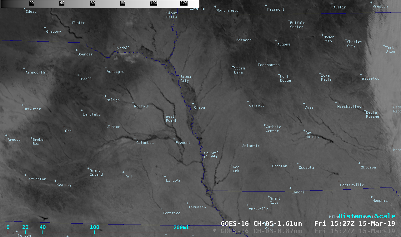
Flooding in South Dakota, Nebraska and Iowa

GOES-16 Near-Infrared “Vegetation” (0.86 µm) and “Snow/Ice” (1.61 µm) images [click to play animation | MP4]
In a toggle between Suomi NPP VIIRS Visible (0.64 µm) and “Snow/Ice” (1.61 µm) images at 1821 UTC (below),1.61 µm imagery showed the darker shades of flooding over a north/south portion of Interstate 29 that was closed from State Highway 34 (west of Glenwood, Iowa) to the Iowa/Missouri border (south of Hamburg, Iowa).
![Suomi NPP VIIRS Near-Infrared "Vegetation" (0.86 µm) and "Snow/Ice" (1.61 µm) images [click to enlarge]](https://cimss.ssec.wisc.edu/satellite-blog/wp-content/uploads/sites/5/2019/03/190315_1821utc_suomiNPP_viirs_snowIce_visible_NE_IA_flooding_Interstate29_closure_anim.gif)
Suomi NPP VIIRS Visible (0.64 µm) and “Snow/Ice” (1.61 µm) images; Interstate Highways are plotted in red, while State Highways are plotted in gray [click to enlarge]
![Terra MODIS True Color and False Color RGB images [click to enlarge]](https://cimss.ssec.wisc.edu/satellite-blog/wp-content/uploads/sites/5/2019/03/190315_1720utc_terra_modis_truecolor_falsecolor_NE_flooding_anim.gif)
Terra MODIS True Color and False Color RGB images, centered over eastern Nebraska [click to enlarge]
![Terra MODIS True Color and False Color RGB images, centered near Vermillion, South Dakota [click to enlarge]](https://cimss.ssec.wisc.edu/satellite-blog/wp-content/uploads/sites/5/2019/03/190315_1720utc_terra_modis_truecolor_falsecolor_SD_NE_IA_flooding_anim.gif)
Terra MODIS True Color and False Color RGB images, centered near Vermillion, South Dakota [click to enlarge]
===== 16 March Update =====
An overpass of the Landsat-8 satellite at 1706 UTC on 16 March provided 30-meter resolution False Color imagery — 2 sections of the swath are shown above and below. The RealEarth link to interactively view the image is here. Closer views centered at the NWS Omaha forecast office (which had to be evacuated due to flooding) and just west of Offutt Air Force Base (about one-third of which was under water) are shown below.![Landsat-8 False Color image. centered at the NWS forecast office in Valley, Nebraska [click to enlarge]](https://cimss.ssec.wisc.edu/satellite-blog/wp-content/uploads/sites/5/2019/03/1903161706utc_landsat8_falsecolor_oax_anim.gif)
Landsat-8 False Color image centered at the NWS forecast office in Valley, Nebraska [click to enlarge]
![Landsat-8 False Color image. centered near Offutt Air Force Base, Nebraska [click to enlarge]](https://cimss.ssec.wisc.edu/satellite-blog/wp-content/uploads/sites/5/2019/03/1903161706utc_landsat8_falsecolor_Offutt_AFB_anim.gif)
Landsat-8 False Color image centered just west of Offutt Air Force Base, Nebraska [click to enlarge]
The #Landsat Dynamic Surface Water Extent (DSWE) science product captured flooding along the Missouri & Platt Rivers in mid-March. These before & after #Landsat8 & DSWE images show the extent of the flooding. DSWE product page: https://t.co/IOfLdcaeNd pic.twitter.com/5dCGwjv3it
— USGS Landsat Program (@USGSLandsat) March 28, 2019


![Terra MODIS True Color and False Color RGB images, centered near Ames, Iowa [click to enlarge]](https://cimss.ssec.wisc.edu/satellite-blog/wp-content/uploads/sites/5/2019/03/190315_1720utc_terra_modis_truecolor_falsecolor_IA_flooding_anim.gif)
![Landsat-8 False Color image. centered to the east of Sioux City, Iowa [click to enlarge]](https://cimss.ssec.wisc.edu/satellite-blog/wp-content/uploads/sites/5/2019/03/190316_1706utc_landsat8_falsecolor_Missouri_River_N_anim.gif)
![Landsat-8 False Color image. centered to the south of Omaha, Nebraska [click to enlarge]](https://cimss.ssec.wisc.edu/satellite-blog/wp-content/uploads/sites/5/2019/03/190316_1706utc_landsat8_falsecolor_Missouri_River_S_anim.gif)