Rain/hail swath in Nebraska and Kansas
#GOES16 RGB imagery shows rain and hail swath from a t-storm today. #NEwx #KSwx pic.twitter.com/pFooa7C5KZ
— NWS Hastings (@NWSHastings) June 26, 2017
** GOES-16 data posted on this page are preliminary, non-operational data and are undergoing testing **
As indicated in the Tweet above from NWS Hastings, GOES-16 imagery highlighted the presence of a narrow swath of rainfall and hail in the wake of a small thunderstorm that moved south/southeastward across the Nebraska/Kansas state line area on 26 June 2017.
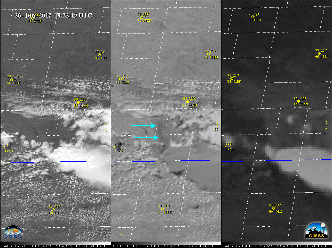
A 3-panel comparison of GOES-16 Visible (0.64 µm), Snow/Ice (1.61 µm) and Shortwave Infrared (3.9 µm) images (below) revealed a subtle signature of the hail swath on the Snow/Ice images (where ice features appear as darker shades of gray: southern NE | northern KS), while the Shortwave Infrared images showed that the hail and rainfall swath — accumulations in southern Kansas included 0.58″ at Clay Center and 0.49″ at Hebron — remained slightly cooler (lighter gray) as the adjacent dry land surfaces continued to warm during the early to middle afternoon hours. SPC storm reports listed hail of 1.75 inches in diameter in southern Nebraska and 1.25 inches in northern Kansas.
![GOES-16 Visible (0.64 µm, left), Snow/Ice (1.61 µm, center) and Shortwave Infrared (3.9 µm, right) images, with hourly surface reports plotted in yellow and SPC storm reports of hail size plotted in red [click to play MP4 animation]](https://cimss.ssec.wisc.edu/satellite-blog/wp-content/uploads/sites/5/2017/06/960x427_GOES16A_B257_G16_3PANEL_NE_HAIL_SWATH_26JUN2017_2017177_185719_0003PANELS.GIF)
GOES-16 Visible (0.64 µm, left), Snow/Ice (1.61 µm, center) and Shortwave Infrared (3.9 µm, right) images, with hourly surface reports plotted in yellow and SPC storm reports of hail size plotted in red [click to play MP4 animation]
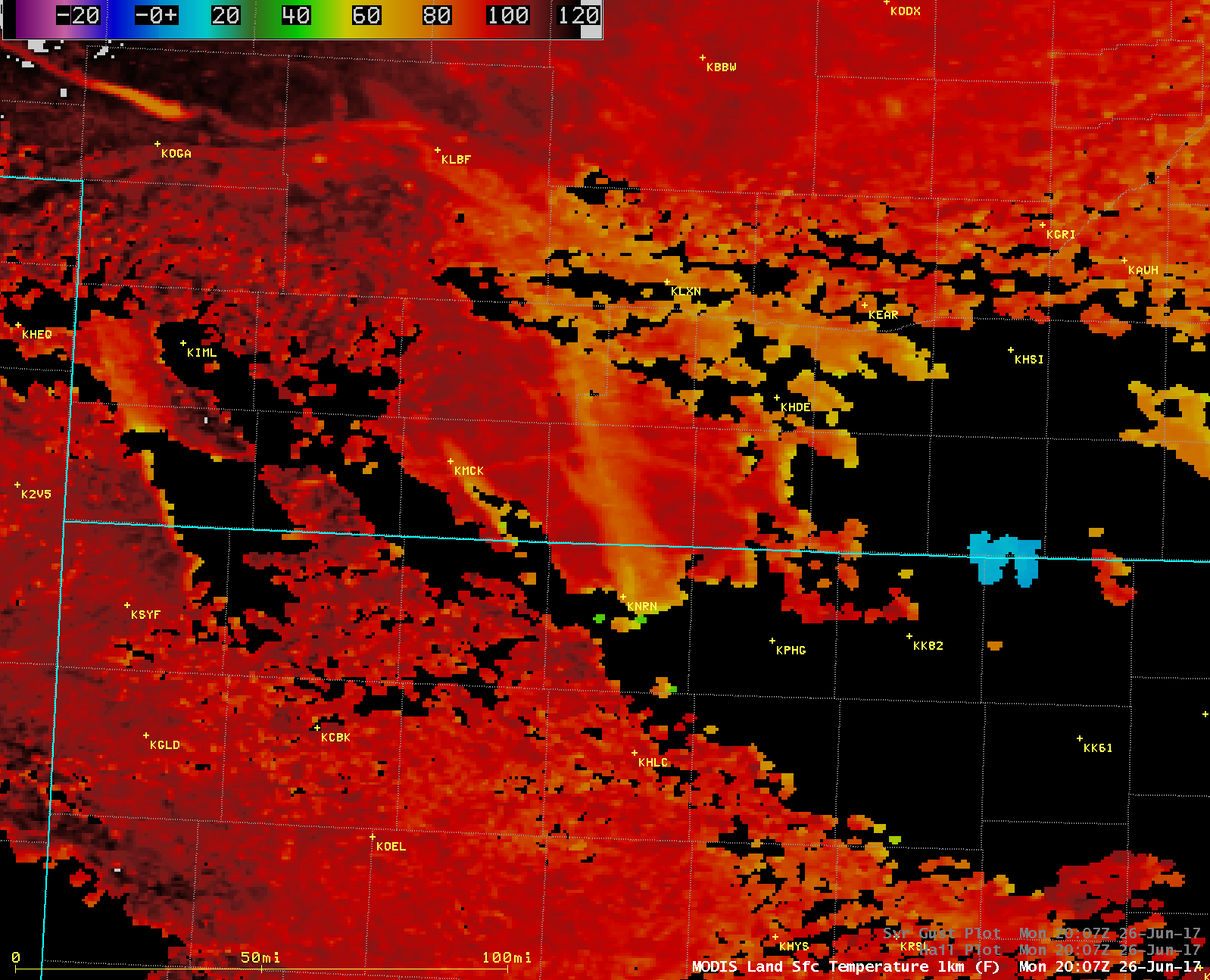
![Aqua MODIS Land Surface Temperature product, Visible (0.65 µm), Infrared Window (11.0 µm) and Shortwave Infrared (3.7 µm) images [click to enlarge]](https://cimss.ssec.wisc.edu/satellite-blog/wp-content/uploads/sites/5/2017/06/170626_2007utc_aqua_modis_LandSurfaceTemperature_Visible_InfraredWindow_ShortwaveInfrared_NE_KS_anim.gif)
Aqua MODIS Land Surface Temperature product, Visible (0.65 µm), Infrared Window (11.0 µm) and Shortwave Infrared (3.7 µm) images [click to enlarge]