Sensing the surface on GOES-13 water vapor imagery
Most users of water vapor satellite imagery interpret the patterns they see as variations in moisture within the middle to upper troposphere — and for the most part, this is often a good first-order assumption. However, one must keep in mind that the water vapor channel is essentially an InfraRed channel, which is sensing the average temperature of a layer of moisture — and the altitude and depth of the layer of moisture being detected can change significantly, based upon such factors as the temperature and/or moisture profile of the atmospheric column, and the viewing angle of the satellite.
During an unusually cold arctic outbreak over the north-central US during the 06 January – 07 January 2014 period, the outline of various portions of the Great Lakes (in particular, Lake Superior, Lake Michigan, and Lake Erie) could actually be seen on GOES-13 6.5 µm water vapor channel imagery (above; click image to play animation). So, how is it possible to see surface features on water vapor channel satellite imagery?
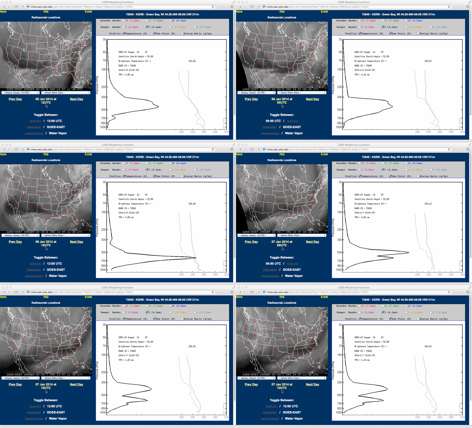
In helping to understand the vertical location and vertical extent of features seen on water vapor imagery, plots of the water vapor “weighting function” (or “contribution function”) can be generated by taking into account the temperature and moisture profile of that location, along with the satellite viewing angle (or “zenith angle”). For this example, plots of GOES-13 Imager 6.5 µm water vapor weighting functions for Green Bay, Wisconsin (below) showed how the altitude and depth of the moisture layer being sensed by the water vapor channel decreased from 12 UTC on 05 January to 12 UTC on 06 January as the core of the cold arctic air moved over the western Great Lakes region. After that time, both the altitude and depth of the moisture layer being detected (as seen on the water vapor channel weighting function plots) began to increase to approximately their pervious values as somewhat warmer and more moist air began to replace the arctic air mass.
Getting back to seeing the outlines of portions of northern Lake Superior, western Lake Michigan, and western Lake Erie: what was being seen on the water vapor imagery was not necessarily the actual surface per se, but the signal of the strong temperature gradient between the cold snow-covered land surfaces and the still-unfrozen waters — and the signal of this strong surface temperature gradient was “bleeding upward” through what little moisture was present in the atmospheric column, and reaching the GOES-13 Imager water vapor detectors.


