Strong Gap Winds Near Alaska’s Alexander Archipelago
One of the most common sayings that a young meteorologist learns early in their education is that “air acts as a fluid.” Gap winds are an excellent illustration of that idea. As a fluid moves through a narrow passage, it has to speed up in order to ensure a constant mass flow rate, just like putting a finger on a garden hose to make a jet of water shoot faster. As air flows through gaps in mountain ranges, the ssame thing happens: the speed of the air increases so that the total mass of air keeps moving at the same rate as it was before it reached the gap.
Southeast Alaska is an ideal location for gap winds. The high, cold territory of British Columbia and the Yukon create large airmasses that flow downhill toward the Pacific Ocean. As these air masses reach southeast Alaska, they are filtered between the rugged islands of the Alexander Archipelago (the Pacific islands that comprise much of southeast Alaska’s territory). Thw air has to accelerate as it is being pushed from behind, and thus rapid winds form through and downstream of the gaps.
This can be seen in satellite products from 22 December 2025. Cross Sound is the body of water between mainland North America and Chichagof Island, the nation’s fifth largest island. The sound is at sea level, of course, but is flanked on either side by ridges that exceed 2000 feet (600 m) with only a 13 mile (20 km) gap between them. This creates a significant opportunity for gap winds. The following image shows the GOES-18 Channel 13 (infrared window) view overlaid with ASCAT winds.

Note that the winds downstream of the Cross Sound gap are 35-40 kts strong. With speeds that fast, these are officially gale force winds. Also note the cloud streets forming parallel to the winds. These are likely caused by the instability created when the cold continental air flows over the relatively warm sea. The “warm” maritime air rises to create convective clouds that are then organized by the winds into bands parallel with the flow.
As noted above, these gap winds form because the cold, dry, dense air masses of northern North America flow downhill to the sea. How cold is it? Let’s zoom out.
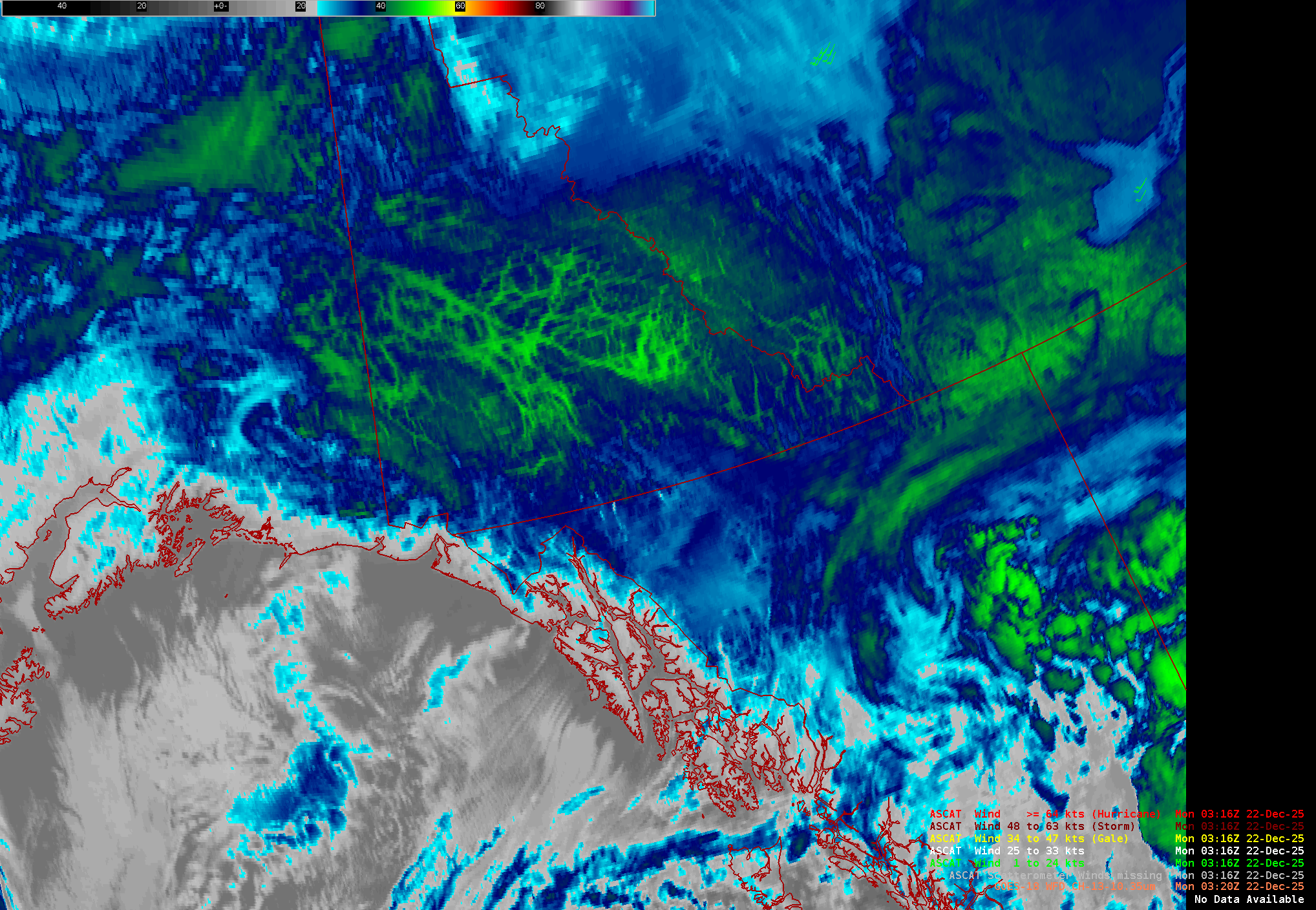
Here, we see the loop of GOES-18 Channel 13 imagery. The default color table in use here is designed for the continental United States. Those blues and greens represent temperatures around -40 F (-40 C) which are associated with moderately deep convection in the Lower 48. However, in the Yukon in December, those are surface temperatures. We can easily see that the Yukon is largely clear just by animating the satellite imagery. Those very cold structures are not moving, which means they’re part of the surface. Thus, we can tell that a very clear night produced bitterly cold air at the surface, a ripe setup for gap flow once that air flowed downhill to the Pacific. This animation also shows that the wind observations are only available for certain frames; this is because ASCAT is mounted aboard polar orbiting satellites and thus isn’t constantly available.
The ASCAT winds aren’t the only satellite-based wind instrument to measure the gap winds. Synthetic Aperture Radar (SAR) is another useful tool. These observations are available here and provide a nigher spatial resolution view of the surface winds over water at the expense of narrower swaths (and thus less frequent coverage). The finer spatial resolution enables us to see not only the gale force winds flowing out of the Cross Sound gap (at the top of the image) but highly localized regions of fast winds emanating from much smaller gaps as well.

A postscript: What does Chicaghof Island, Alaska, have in common with Chicago, Illinois, besides their very similar names? They’re both famous for bears! Chicaghof Island has the highest concentration of bears per unit area of any place on earth, while American football fans are quite familiar with Chicago’s Bears.