Tropical Storm Delta becomes a Hurricane over the Caribbean Sea

GOES-16 “Clean” Infrared Window (10.35 µm) images (with and without an overlay of GLM Flash Extent Density) and “Red” Visible (0.64 µm) images [click to play animation | MP4]
A toggle between GOES-16 Infrared and Visible images at 2156 UTC (below) revealed a small tropical overshooting top near the center of the developing convective burst — which exhibited a cloud-top infrared brightness temperature as cold as -93.2ºC (yellow pixels embedded within the darker shades of purple).
![GOES-16 “Clean” Infrared Window (10.35 µm) images (with an overlay of GLM Flash Extent Density) and "Red" Visible (0.64 µm) images at 2156 UTC [click to enlarge]](https://cimss.ssec.wisc.edu/satellite-blog/images/2020/10/201005_2156utc_goes16_visible_infrared_Delta_anim.gif)
GOES-16 “Clean” Infrared Window (10.35 µm) images (with an overlay of GLM Flash Extent Density) and “Red” Visible (0.64 µm) images at 2156 UTC [click to enlarge]
===== 06 October Update =====
![GOES-16 “Clean” Infrared Window (10.35 µm) images (with and without an overlay of GLM Flash Extent Density) and “Red” Visible (0.64 µm) images [click to play animation | MP4]](https://cimss.ssec.wisc.edu/satellite-blog/images/2020/10/201006_goes16_infrared_glmFlashExtentDensity_visible_Huricane_Delta_2_anim.gif)
GOES-16 “Clean” Infrared Window (10.35 µm) images (with and without an overlay of GLM Flash Extent Density) and “Red” Visible (0.64 µm) images [click to play animation | MP4]
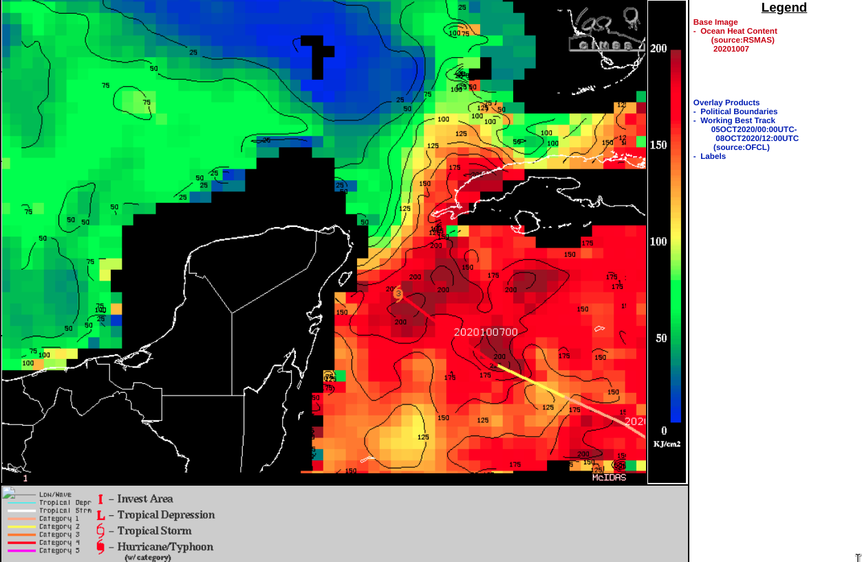
GOES-16 Infrared Window (11.2 µm) images from the CIMSS Tropical Cyclones site (below) indicated that Delta was moving through an environment of low deep-layer wind shear as the hurricane was moving over water possessing very high ocean heat content.
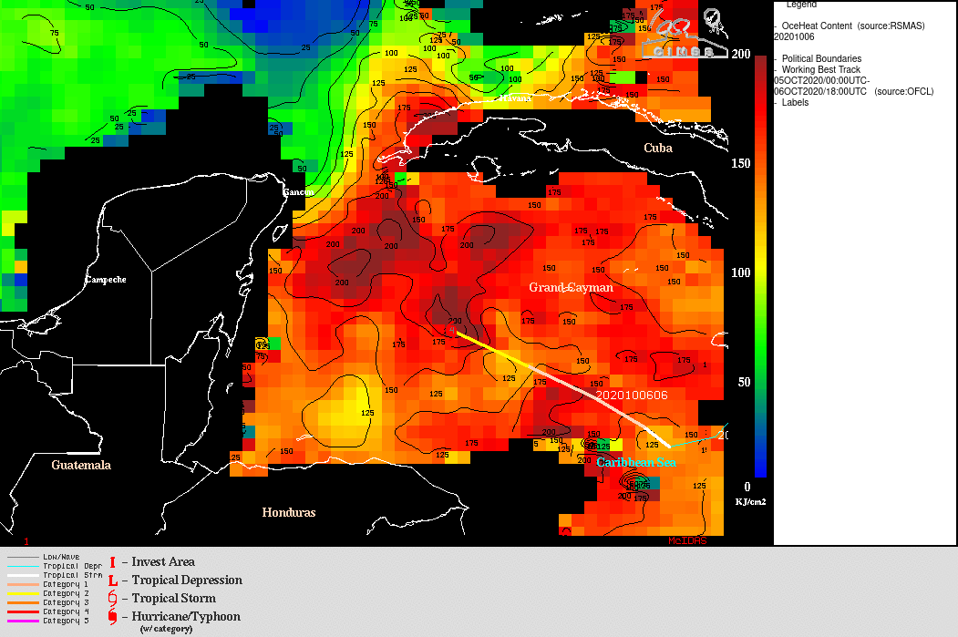
![GOES-16 Infrared Window (11.2 µm) images, with an overlay of deep-layer wind shear [click to enlarge]](https://cimss.ssec.wisc.edu/satellite-blog/images/2020/10/201006_goes16_infrared_shear_Delta.gif)
GOES-16 Infrared Window (11.2 µm) images, with an overlay of deep-layer wind shear [click to enlarge]
===== 07 October Update =====
![Suomi NPP VIIRS Infrared Window (11.45 µm) and Day/Night Band (0.7 µm) images [click to enlarge]](https://cimss.ssec.wisc.edu/satellite-blog/images/2020/10/201007_0632utc_suomiNPP_viirs_infraredWindow_dayNightBand_Hurricane_Delta_anim.gif)
Suomi NPP VIIRS Infrared Window (11.45 µm) and Day/Night Band (0.7 µm) images [click to enlarge]
A time-matched comparison of Infrared images from Suomi NPP and GOES-16 is shown below; a cloud-top infrared brightness temperature of -95.8ºC was sensed by GOES-16. There was significant parallax associated with the Suomi NPP image, since Hurricane Delta was located along the far western edge of the descending overpass swath. The same color enhancement is applied to both images.
![Infrared images from Suomi NPP and GOES-16 [click to enlarge]](https://cimss.ssec.wisc.edu/satellite-blog/images/2020/10/201007_0644utc_suomiNPP_goes16_infraredWindow_Hurricane_Delta_anim.gif)
Infrared images from Suomi NPP and GOES-16 [click to enlarge]