Canadian wildfire smoke over Quebec, Maine and the Canadian Maritimes
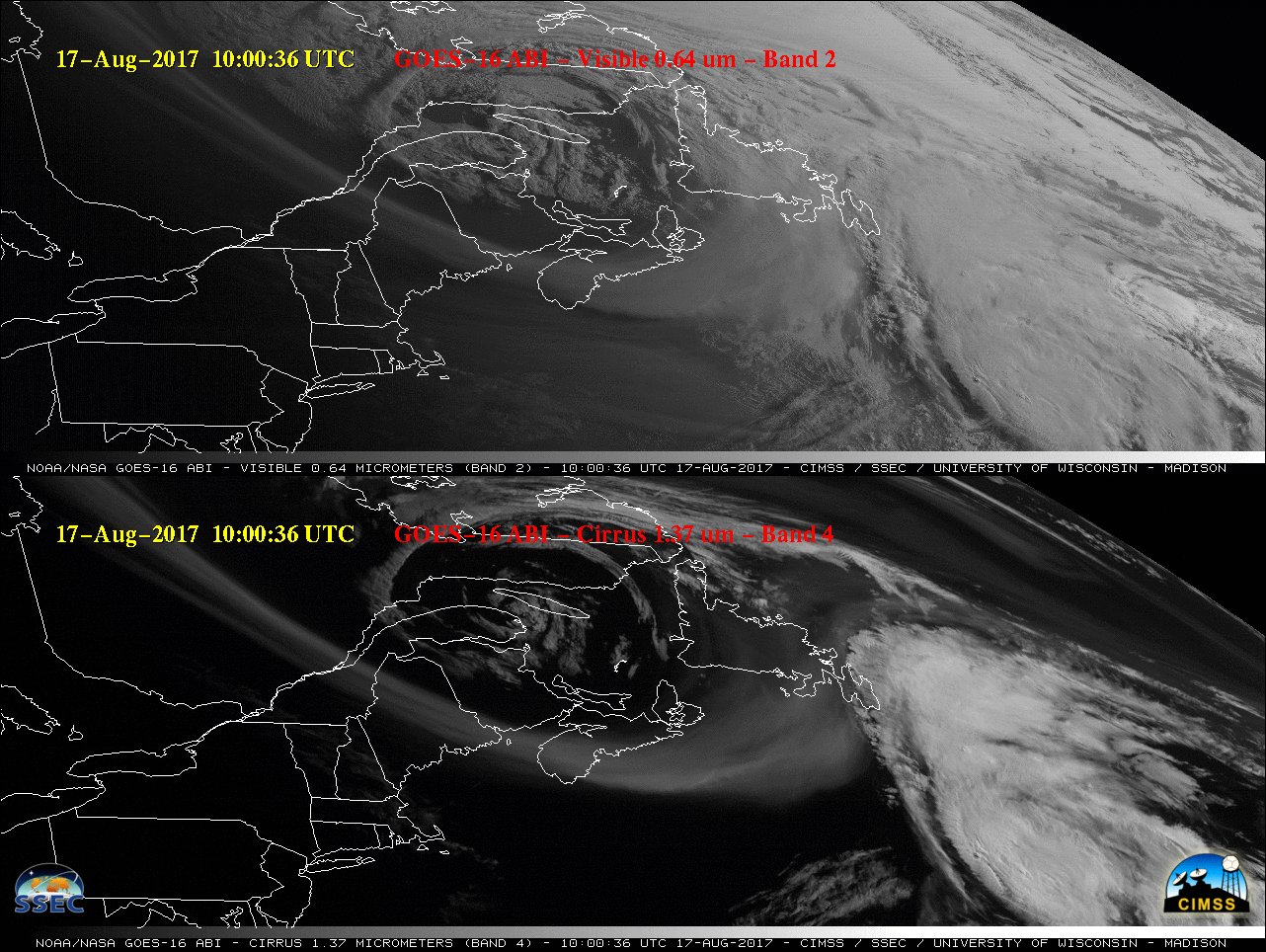
![GOES-16 Visible (0.64 µm, top) and Cirrus (1.37 µm, bottom) images [click to play MP4 animation]](https://cimss.ssec.wisc.edu/satellite-blog/wp-content/uploads/sites/5/2017/08/G16_VIS_CIRRUS_SMOKE_MARITIMES_17AUG2017_480x1280_B24_2017229_101536_0002PANELS_00002.GIF)
GOES-16 Visible (0.64 µm, top) and Cirrus (1.37 µm, bottom) images [click to play MP4 animation]
Filaments of smoke aloft from Canadian wildfires were evident in GOES-16 “Red” Visible (0.64 µm) and Cirrus (1.37 µm) imagery (above; also available as a 24 Mbyte animated GIF) on 17 August 2017, drifting cyclonically eastward over Quebec, Maine and the Canadian Maritimes. The appearance of the smoke signature on Cirrus images was due to the fact that this spectral band is useful for detecting features composed of particles that are efficient scatterers of light (such as cirrus cloud ice crystals, airborne dust or volcanic ash, and in this case, smoke).
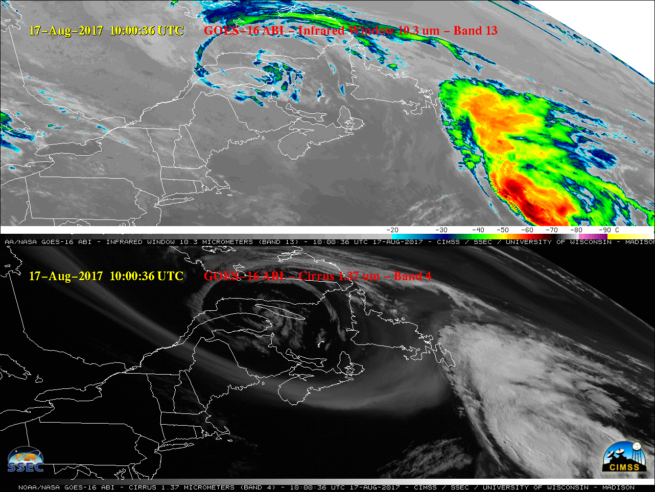
A comparison of GOES-16 “Clean” Infrared Window (10.3 µm) and Cirrus (1.37 µm) images (below; also available as a 21 Mbyte animated GIF) demonstrated that no smoke signature was seen on the infrared images (since smoke is effectively transparent at infrared wavelengths).
![GOES-16 Infrared Window (10.3 µm, top) and Cirrus (1.37 µm, bottom) images [click to play MP4 animation]](https://cimss.ssec.wisc.edu/satellite-blog/wp-content/uploads/sites/5/2017/08/G16_IR_CIRRUS_SMOKE_MARITIMES_17AUG2017_480x1280_B134_2017229_101536_0002PANELS_00002.GIF)
GOES-16 Infrared Window (10.3 µm, top) and Cirrus (1.37 µm, bottom) images [click to play MP4 animation]
![Terra MODIS Visible (0.65 µm), Cirrus (1.375 µm) and Infrared Window (11.0 µm) images [click to enlarge]](https://cimss.ssec.wisc.edu/satellite-blog/wp-content/uploads/sites/5/2017/08/170817_1626utc_terra_modis_Visible_Cirrus_InfraredWindow_Canadian_wildfire_smoke_anim.gif)
Terra MODIS Visible (0.65 µm), Cirrus (1.375 µm) and Infrared Window (11.0 µm) images [click to enlarge]
![Suomi NPP VIIRS daily true-color images [click to enlarge]](https://cimss.ssec.wisc.edu/satellite-blog/wp-content/uploads/sites/5/2017/08/170812-17_suomi_npp_viirs_truecolor_Canada_wildfire_smoke_anim.gif)
Suomi NPP VIIRS daily true-color images [click to enlarge]