Typhoon Soudelor in the Pacific
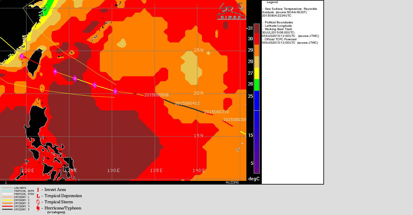
The animation above (link) shows two-plus days of 10.35 µm Infrared imagery (from Himawari-8) of Typhoon Soudelor over the western Pacific Ocean. The animation of 2.5-minute interval images is from the Himawari-8 Target Sector that shifts as the Typhoon moves. The animation shows significant strengthening to Category 5 intensity and subsequent weakening as the storm undergoes an eyewall replacement cycle (ERC). That ERC is apparent in the MIMIC morphed microwave imagery, below. In addition, an SST Analysis from the CIMSS Tropical Cyclones site shows the storm traversing an area of relatively cooler Sea Surface Temperatures. Strengthening is expected in the next days as the storm approaches Taiwan.
![Morphed Microwave Imagery centered on Soudelor, 1200 UTC 3 August - 1200 UTC 5 August 2015 [click to enlarge]](https://cimss.ssec.wisc.edu/satellite-blog/wp-content/uploads/sites/5/2015/08/Soudelorlast48hrs_ending1200UTC5AugMIMIC.gif)
Morphed Microwave Imagery centered on Soudelor, 1200 UTC 3 August – 1200 UTC 5 August 2015 [click to enlarge]
![Himawari-8 0.52 µm imagery, 3-4 August 2015 [click to play animation]](https://cimss.ssec.wisc.edu/satellite-blog/wp-content/uploads/sites/5/2015/08/1000x1000_AHIM08_B2_SOUDELOR_animated_2015215_203215_86_2015216_095945_86_GRAY.gif)
Himawari-8 0.52 µm imagery, 3-4 August 2015 [click to play 100+ Megabyte animation]
![Suomi NPP VIIRS Day/Night Band visible imager (0.70 µm) and infrared (11.45 µm) image at 1608 UTC 4 August 2015 [click to enlarge]](https://cimss.ssec.wisc.edu/satellite-blog/wp-content/uploads/sites/5/2015/08/ToggleI05_DNB_080415_1608_1.5E-8_TCSoudelor.gif)
Suomi NPP VIIRS Day/Night Band visible image (0.70 µm) and infrared (11.45 µm) image at 1608 UTC 4 August 2015 [click to enlarge]