


1-min GOES-14
2012, 2013, 2014 and 2015
SRSOR GOES-14 1min data
20122013
2014
2015
January 2010 AMS Conference...
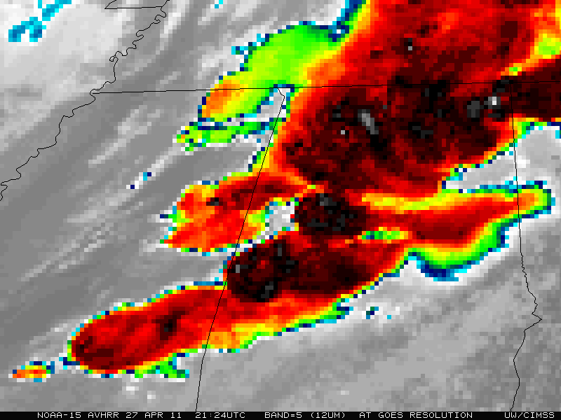
NOAA AVHRR...
May 4, 2011
NOAA AVHRR image of the US storms in the Southeast on April 27, 2011 at the GOES-R resolution:
AVHRR data remapped to the GOES-R ABI projection.AVHRR data remapped to the GOES-R ABI projection, but shown at 2 times poorer resolution.
Side-by-Side Swipe Method

ABI talk at AMS Conference...
January 25, 2011
Presentation on the ABI at the annual AMS conference:
Presentation in PPT format (large file)ABI talk at AMS Satellite Conference...
September 30, 2010
Presentation on the ABI at the 17th Satellite conference:
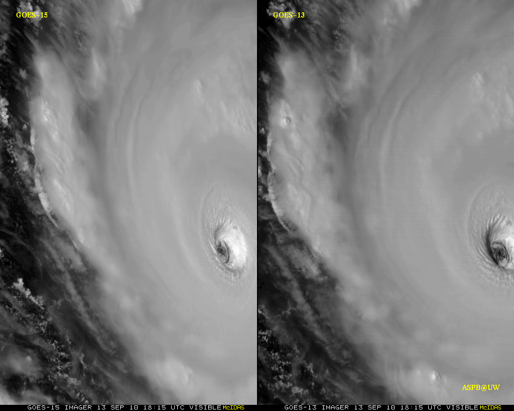
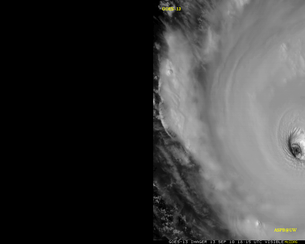
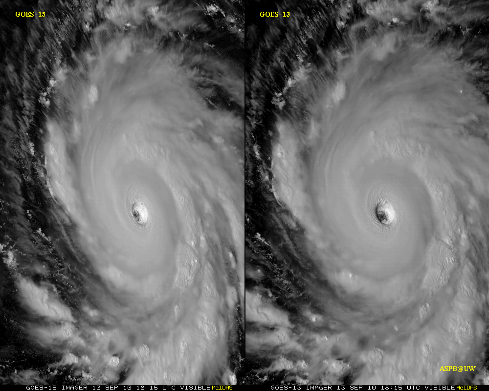
Presentation in PPT format (large file)GOES-15 1-min resolution data on Hurricane Igor...
September 17, 2010
GOES-13 versus GOES-15 high-time resolution loops of Igor:
GOES-13 vs GOES-15 visible loop (animated gif)GOES-13 only (animated gif)
GOES-13 vs GOES-15 -less magnification (animated gif)
Note that these images have been digitally stretched.
GOES-14 1-min resolution data...
April 20, 2010
GOES-12 versus GOES-14 high-time resolution loops:
GOES-12 vs GOES-14 visible loop (animated gif)HD: GOES-12 vs GOES-14 visible loop (animated gif)
Sample ABI simulated data...
January, 2010
ABI-Simulated Data Examples:Preliminary
Images in Google Earth and other formats (netCDF, etc)January 2010 AMS Conference...
January, 2010
Tim Schmit et al. powerpoint presentation:The ABI on GOES-R
Presentation in PDF formatPresentation in PPT format (large file)
6th GOES Users' Conference...
November, 2009
Tim Schmit et al. powerpoint presentation:The ABI on GOES-R
Presentation in PPT format (large file)2009 MUG Meeting...
June, 2009
Tim Schmit et al. powerpoint presentation:The ABI (Advanced Baseline Imager) on the GOES-R series
Presentation in PDF formatPresentation in PPT format
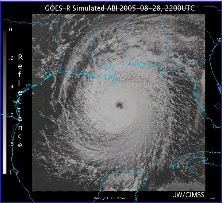
Simulated ABI of Hurricane Katrina...
December 18, 2008
Simulated (by the AWG proxy team) 16 ABI bands for Hurricane Katrina:as an animated gif.Displayed with the McIDAS-V.
AnimationJanuary 2008 AMS Conference...
January 21, 2008
Tim Schmit et al. powerpoint presentation:The ABI on GOES-R
Presentation in PDF formatPresentation in PPT format (large file)
GOES-R ABI Weighting Functions ...
January 4, 2008
ABI IR Weighting Functions:
Web page with pre-comptuted ABI IR weighting functionsfor the clear-sky.GOES-10 Sounder and Imagerfor the clear-sky.GOES-13 Sounder and Imagerfor the clear-sky.
GOES-R ABI bit-depth ...
May 25, 2007
Preliminary information regarding ABI IR bit-depth:
This file summarizestheminimumABI bit depths for the IR bands (D. Hillger and T. Schmit);assuming a noise factor of 2.5 better than spec.Also see a related AMSpre-print article from 2004.
A spreadsheetwas used to check the IR ABI bit depth calculations.
A memo from 1991on the GOES-I/M GVAR scale coeffs.
GOES ABI seminar ...
April 11, 2007
Seminar:
This presentation on the GOES-R ABIwas given on January 17th, 2007.
GOES seminar ...
March 20, 2006
Seminar:
This presentation on GOESwas given as a NOAA/NESDIS STAR seminar on March 17th, 2006.
Simulated ABI datasets ...
December 23, 2005
Simulated ABI datasets:
These pagesdescribe how select MODIS (MODerate-resolution Imaging Spectroradiometer) (and other satellite) data have been reformatted for use in ABI (Advanced Baseline Imager) data compression studies.
ABI article ...
August 17, 2005
An ABI overview article:
T. J. Schmit, M. M. Gunshor, W. Paul Menzel, Jun Li, Scott Bachmeier, James J. Gurka, 2005: Introducing the Next-generation Advanced Baseline Imager (ABI) on GOES-R, Bull. Amer. Meteor. Soc., Vol 8, August, pp. 1079-1096.
Contact the ABI Team for a copy of the manuscript:E-Mail Contact FormDust via the thermal IR ...
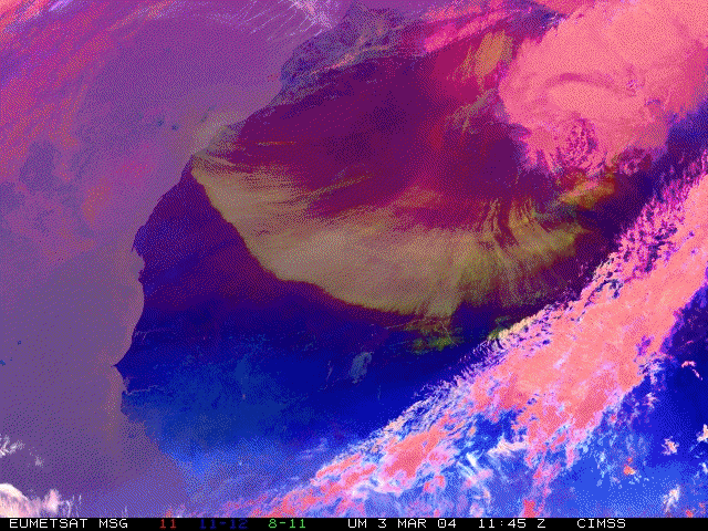
July 25, 2005
Dust detection from EUMETSAT's MET-8:Java appletandAnimated GIF image
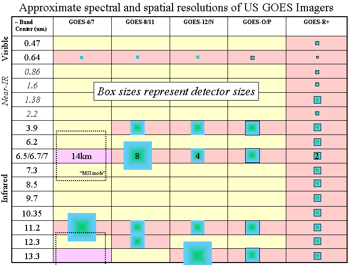
GOES Imagers ...
March 15, 2005
Spatial and Spectral GOES US imager comparison:
GIF image
ABI Simulated SRFs ...
March 02, 2005
These are similar to those listed below for October 21, 2003. With code borrowed from Mike Griffin of MIT-LL, these spectral response functions were created because they fit the full-width half-max points accurately. These have been nicknamed "GBH" which stands for "Gaussian-Boxcar Hybrid" because they have a gaussian curve for the sides and then flatten out at the top like a boxcar function.
The only differences between this release of SRFs (02Mar2005) and the previous release (23Jan2004) are in these three bands:
Band 3	FROM 0.84-0.88   (0.86)	TO 0.846-0.885 (0.865)
Band 4	FROM 1.365-1.395 (1.38)	TO 1.371-1.386 (1.378)
Band 6	FROM 2.235-2.285 (2.26)	TO 2.225-2.275 (2.25)
You can FTP these files fromftp://ftp.ssec.wisc.edu/ABI/SRF- FTP anonymously to the machine ftp.ssec.wisc.edu and go into the ABI/SRF directory. The SRFs are ascii text files and there is a readme file as well. Older versions are there in separate directories.
ABI Simulated Image fader ...
February 16, 2005
Fade between a GOES and "ABI" (from MODIS) image:
Java applet that fades between a GOES and "ABI" image
Animated GIF of GOES and "ABI" image
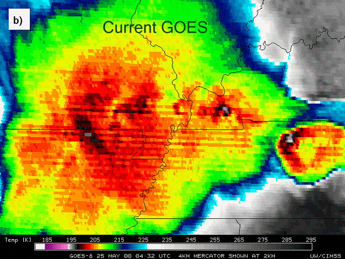
Improved spatial resolution of the infrared window bands of the ABI demonstrated from MODIS data (a) for a convective cloud case. Note the colder cloud-top brightness temperatures and the sharper "Enhanced V" signature located over central Tennessee on 25 May 2000. Also of interest are the concentric anvil-layer waves observable in the higher spatial resolution IR data, associated with rapidly intensifying convection along the Missouri/Arkansas border region. These are not evident in (b), the current GOES imager data.Misc. pdf of a GOES-R summary:
GOES-R Summary Presentation in PDF format
ABI Weighting Functions ...
February 10, 2005
Link to pages with various ABI WFs:
GOES-R ABI clear-sky weighting functions
May 2004 Third GOES-R Users Conference ...
July 22, 2004
Tim Schmit et al. powerpoint presentation:The GOES-R Series Advanced Baseline Imager (ABI)
Presentation in Powerpoint format
Allpresentations from this conference can be found atthis FTP site.
Proposed GOES-R Logo...
February 23, 2004
Large JPEG image Small JPEG image Transparent GIF imageABI vs. GOES Temporal Resolution,5-Minute "Morph" Time Sequences...
March 2, 2004
Comparison from24 February, 2004
Western Atlantic RegionSide-by-side Comparisons Java AVI
Near full diskSide-by-side Comparisons Java AVI
Approximate ABI vs. GOES Temporal Resolution...
February 25, 2004
Comparison usingHurricane Isabel, 12 Sept. 2003
Approximate ABI Sample Java AVI
Side-by-side Comparison Java AVI
January 2004 AMS Conference...
January 21, 2004
Tim Schmit et al. powerpoint presentation:Study of ABI on the GOES-R and Beyond
Presentation in PDF formatABI-Related Links...
January 12, 2004Click here
MODIS Broadcast to Simulate ABI Bands...
November, 2003
See spectrally simulated ABI images from MODIS data. Images are updated
daily at 23:20 UTC.
Simulated ABI Images -- Java Loop
ABI simulated WFs...
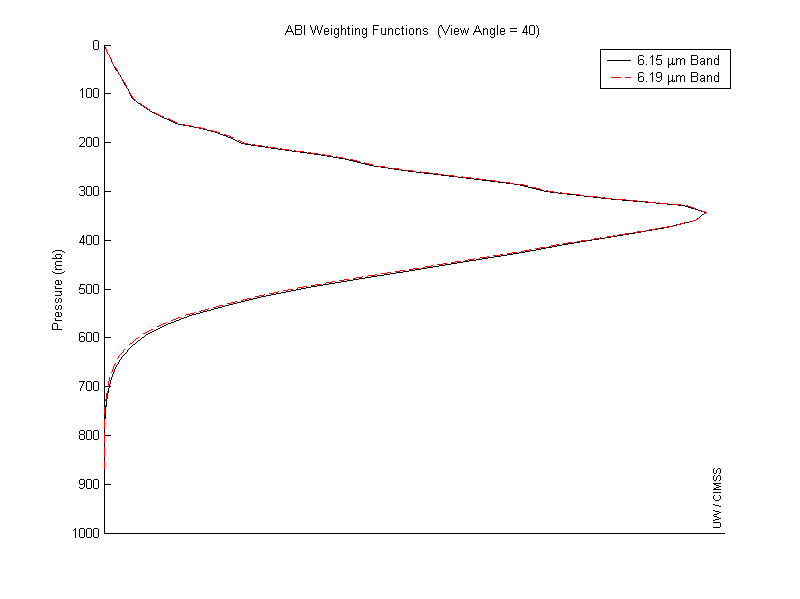
October 21, 2003
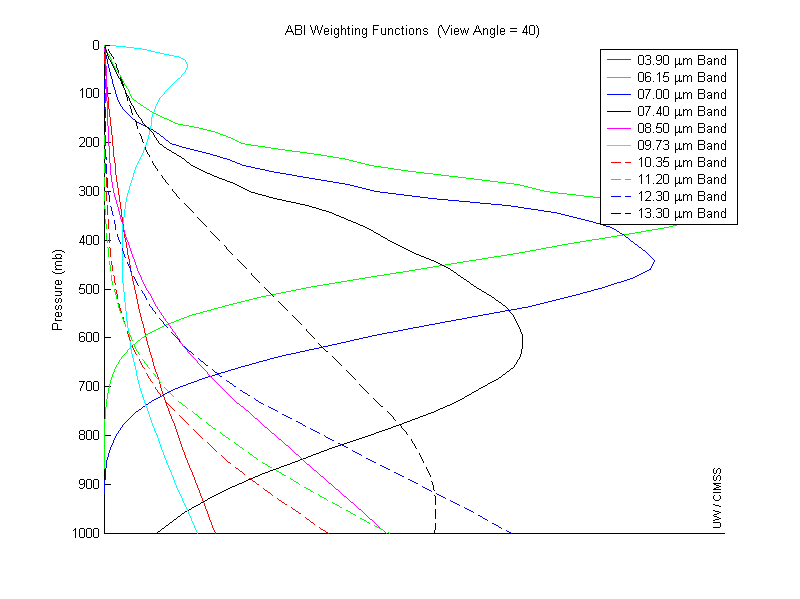
The SRFs in "New SRF simulations" from October 21, 2003 (below) are used here to create weighting functions for the U.S. Standard Atmosphere with a view angle of 40 and surface pressure of 1000mb.
- See how the weighting function of the 6.15 µm band (8 - current
spec in PORD) compares to the adjusted 6.19 µm band (18) in thisfigure.
- See how the weighting function of the 7.00 µm band (9 - current
spec in PORD) compares to the adjusted 6.95 µm band (19) in thisfigure.
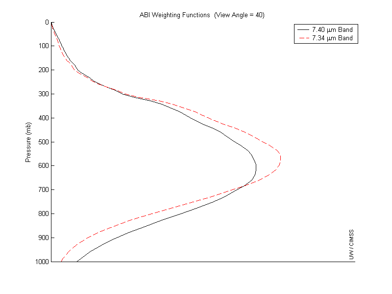
- See how the weighting function of the 7.40 µm band (10 - current
spec in PORD) compares to the adjusted 7.34 µm band (20) in thisfigure.
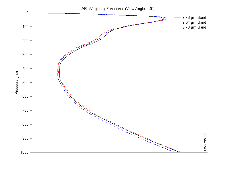
- See how the weighting function of the 9.73 µm ozone band (12
- current spec in PORD) compares to the adjusted 9.61 µm band (17) and
the 9.7 µm band (21 - the original ozone band) in thisfigure.
- Or see all 10 of the IR bands (7-16) that are spec in the current PORD
in thisfigure
A preliminary/working draft of the Performance Operation Requirement Document (PORD) is available from NASA athttp://goes2.gsfc.nasa.gov/abihome.htm
New SRF simulations...
October 21, 2003
With code borrowed from Mike Griffin of MIT-LL, these spectral response functions were created because they fit the full-width half-max points accurately, whereas the older "Mock" SRFs did not. These have been nicknamed "GBH" which stands for Gaussian-Boxcar Hybrid because they have a gaussian curve for the sides and then flatten out at the top like a boxcar function.
See theplot here.
You can FTP them fromftp://ftp.ssec.wisc.edu/ABI/SRF- FTP anonymously to the machine ftp.ssec.wisc.edu and go into the ABI/SRF directory. The SRFs are there in ascii text files (grab everything there, which will include a readme).
Download the current bandwidthspecifications(current as of October 2003)
Notes: The current plan is for there to be 16 bands on the ABI. The first 6 are visible/near IR bands. There currently is not an official band numbering; the band numbering provided here is provided for simplification.
AIRS Broadcast to Simulate ABI IR Bands...
June 30, 2003
See spectrally simulated ABI images from AIRS data. Images are updated
daily at 23:00 UTC.
Simulated ABI Images -- Java Loop
Simulated Visible & near IR ABI Images...
June 6, 2002
Last update: June 30, 2003
Simulated visible and near IR ABI images were created by convolving high
spectral resolution aircraft data from the AVIRIS instrument. From the
AVIRIS radiance files, specific ABI bands were made into smaller radiance
files using a program from Michael Griffin from MIT/LL. From these
radiance files images were created using the ENVI software. Click on
the link to continue to the images.
Visible & near IR images
January 2003 ABI Seminar...
January 28, 2003
Tim Schmit et al. powerpoint presentation:Bands and Products from the
Next Generation Geostationary Imager -- the ABI
Presentation
in PDF format
Shortened
presentation
VISITview
ABI Lesson.
MODIS Visible Bands Used for ABI Compression Studies... July 15, 2002 View the Compressed MODIS Visible Bands Simulated ABI Images...
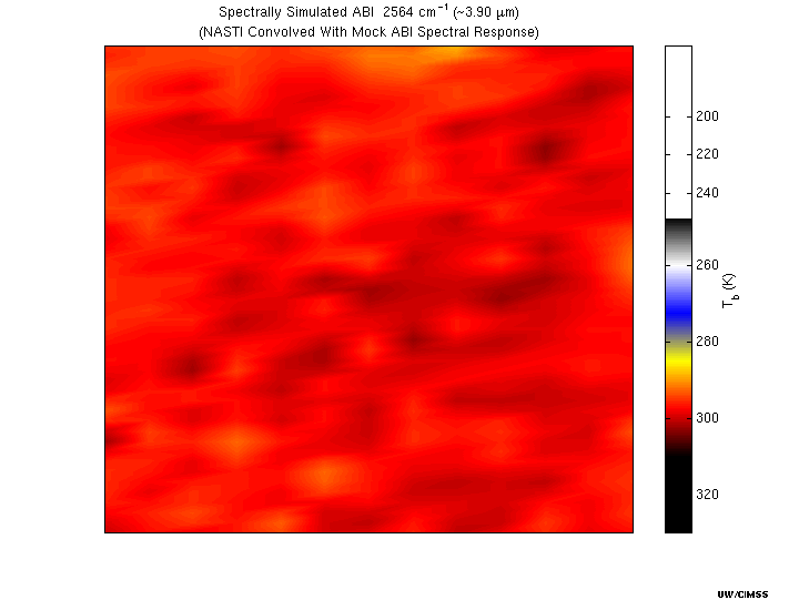
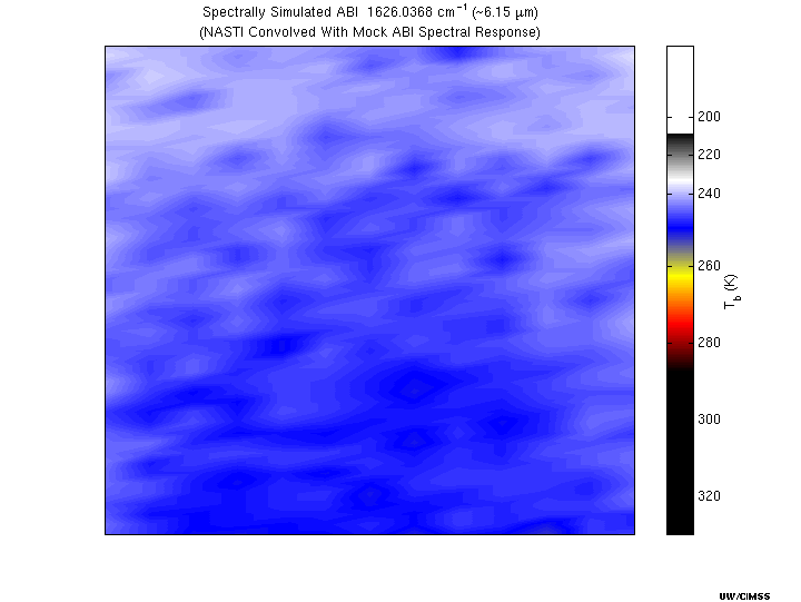
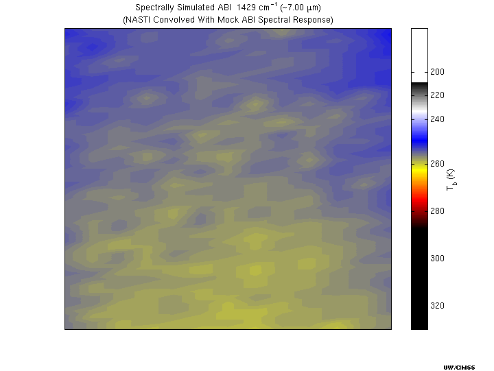
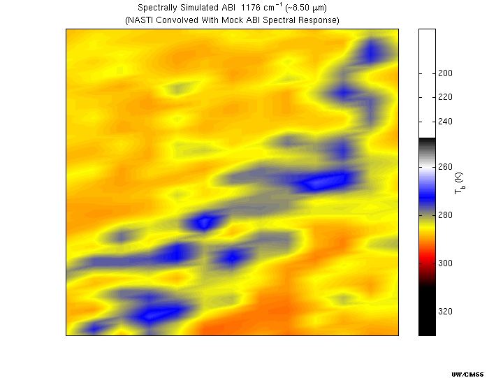
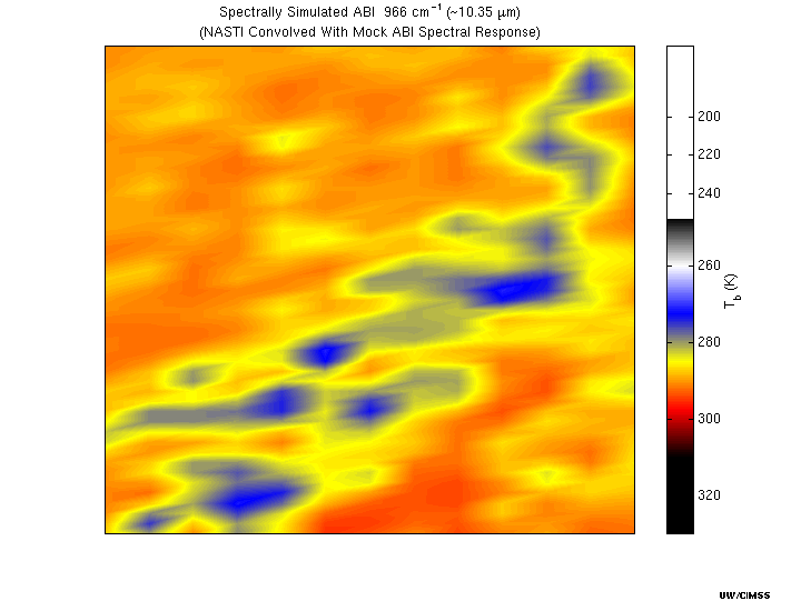
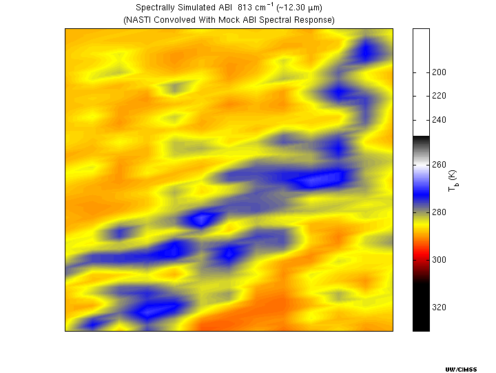
Simulated ABI images were created by convolving high spectral resolution aircraft data from the NAST-I instrument with the mock ABI spectral response functions. Click on the band number to view the image.
ABI Power Point Presentation...
In February, 2000 Tim Schmit presented an updated plan to the University of Wisconsin's Cooperative Institute for Meteorological Satellite Studies (CIMSS). You can view thePDFAdobe Acrobat version which opens in a new window (this file is approximately 7mb and is best viewed with Acrobat Reader 4.0). Ordownloadthe original Microsoft Powerpoint (Microsoft Office 97 SR-1) presentation. ABI 12 Channel Proposed Bandwidths...October 25, 1999
The Proposed Bandwidths (IR only) are plotted with a HIS Brightness Temperature Spectrum comparing the12 channelproposal to the old8 channel...
ABI Power Point Presentation...
On September 23, 1999 Tim Schmit presented a plan at the NOAA R&D Council Meeting for a 10 Band ABI instrument. You can view theslideshowordownloadthe original Microsoft Powerpoint (Microsoft Office 97 SR-1) presentation. ABI Proposed Bandwidths...June 16, 1999ABI (June, 1999)
The Proposed Bandwidths are plotted with the HIS Brightness Temperature Spectrum...
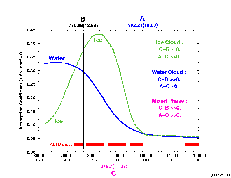
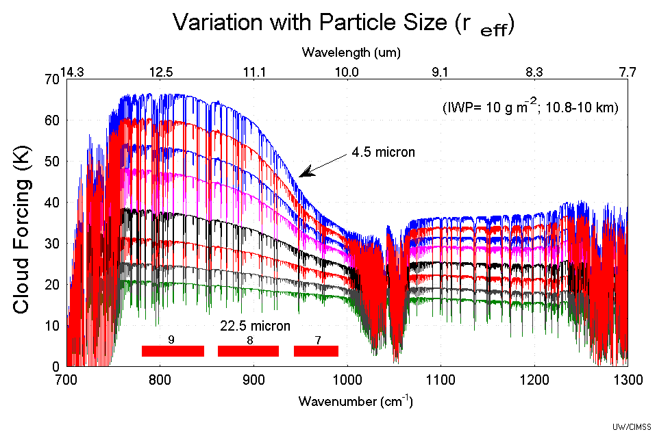
Cloud Phase and ABI Channelsplotcourtesy of Allen Huang. Cirrus Cloud Particle Effective Radiusplotfrom
"Model Calculations and Interferometer Measurements of Ice Cloud Characteristics."
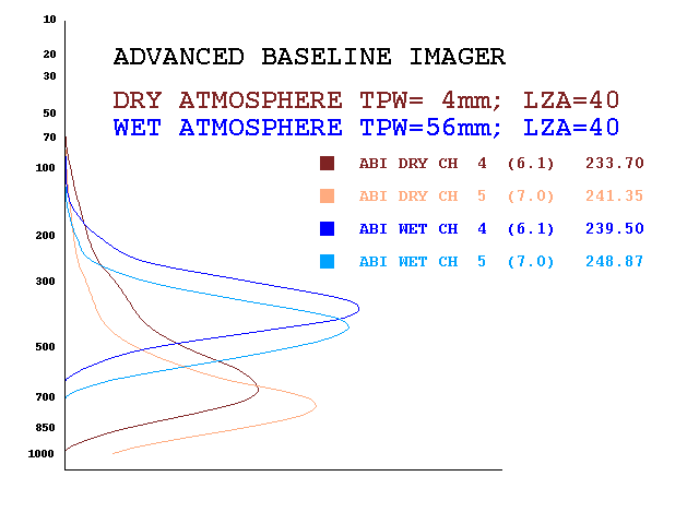
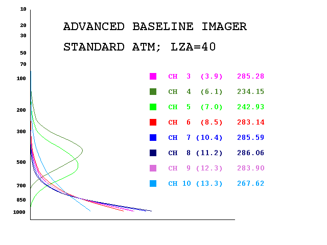
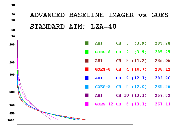
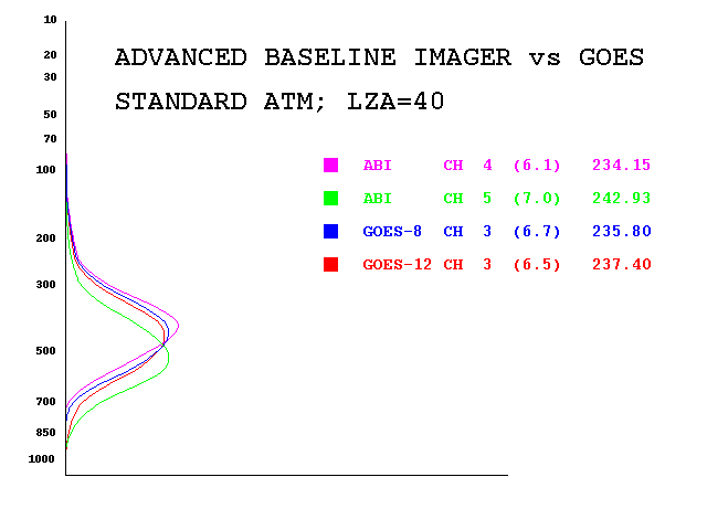
by Sunggi Chung, Steven Ackerman, Paul F. van Delst, and W. Paul Menzel. Weighting Functions...August 13, 1999Weighting functions for examplewet and dryatmospheres were calculated for the mock spectral response functions for ABI proposed water vapor channels (4 and 5). The weighting functions were calculated for example wet and dry atmospheres with a zenith angle of 40. The numbers in parentheses are central wavelengths (mm) and the corresponding brightness temperatures (degrees Kelvin) also appear on the plot. Weighting functions for the mock spectral response functions have been calculated for ABI proposed channels 3-10. The weighting functions were calculated for a standard atmosphere with a zenith angle of 40. The numbers in parentheses are central wavelengths (mm) and the corresponding brightness temperatures (degrees Kelvin) also appear on the plots. The plot ofABI channels 3-10.The plot of"surface viewing" channels 3, 8, 9, and 10with corresponding GOES-8 (chs 2, 4, 5) and GOES-12 (ch 6) imager channels. The plot ofwater vapor channelsshows channels 4 and 5 of the ABI along with GOES-8 channel 3 and GOES-12 channel 3. ABI Slideshow Presentation...
View the slides from theABI slideshow presentation. Spectral Response Functions...
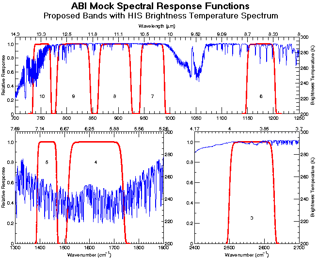
Mock Spectral
Response Functionsare plotted with the HIS Brightness Temperature
Spectrum. Other satellite bandwidths...
ABI (Study Report: November, 1998) Ch Wavelength
|


Back to the CIMSS Home Page
Last updated: February, 2010.
URL:http://cimss.ssec.wisc.edu/goes/abi
Questions or comments:SSEC
Webmaster