Meteorology » Aviation Weather
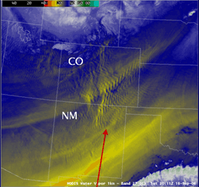
Turbulence detected on water vapor imagery
Satellite data is critical to safe air travel. Along with routine displays of clouds and weather systems, satellite images are used to generate upper air winds at all levels of the atmosphere around the entire globe. Tools based on real-time satellite data also help pilots steer clear of aviation hazards such as turbulence and volcanic ash.
In this lesson you will learn about:
- Satellite derived winds
- Clear Air Turbulence
- Volcanic Ash
Time requirement
This lesson will take you approximately 40 minutes to complete.