Phoenix dust storm, and a resulting Mesoscale Convective Vortex over southern California
Strong thunderstorm outflow winds (gusting as high as 69 mph) created a severe dust storm (or “haboob“) in the Phoenix, Arizona area around 02:00 to 03:00 UTC on 06 July 2011 (or 7pm to 8pm local time on 05 July 2011), restricting the surface visibility to near zero with blowing dust and forcing a 45-minute Ground Stop at Phoenix Sky Harbor Airport (an interesting YouTube video of the approaching dust storm is available here). The Phoenix National Weather Service forecast office published a summary of the event, and additional information and 3D radar animations are available on the AccuWeather WeatherMatrix blog. A high-resolution GOES image can be found at the NOAA Environmental Visualization Laboratory.
McIDAS images of GOES-11 0.65 µm visible channel data during the day and GOES-11 10.7 µm IR channel data at night (above; click image to play animation) show how the Mesoscale Convective System over Arizona on 05 July evolved into a Mesoscale Convective Vortex (MCV) on the following morning over the deserts of southern California, as the cirrus canopy of the convective system eroded to reveal the mid-level circulation. The MCV then appeared to play a role in helping to initiate new convective activity over California later in the afternoon on 06 July.
MCVs maintain their structure through the release of latent heat associated with condensation when clouds form and especially when precipitation forms. This release of heat alters the stability of the atmosphere, inducing the formation of a cyclonic potential vorticity anomaly. MCVs erode when they encounter high wind shear.
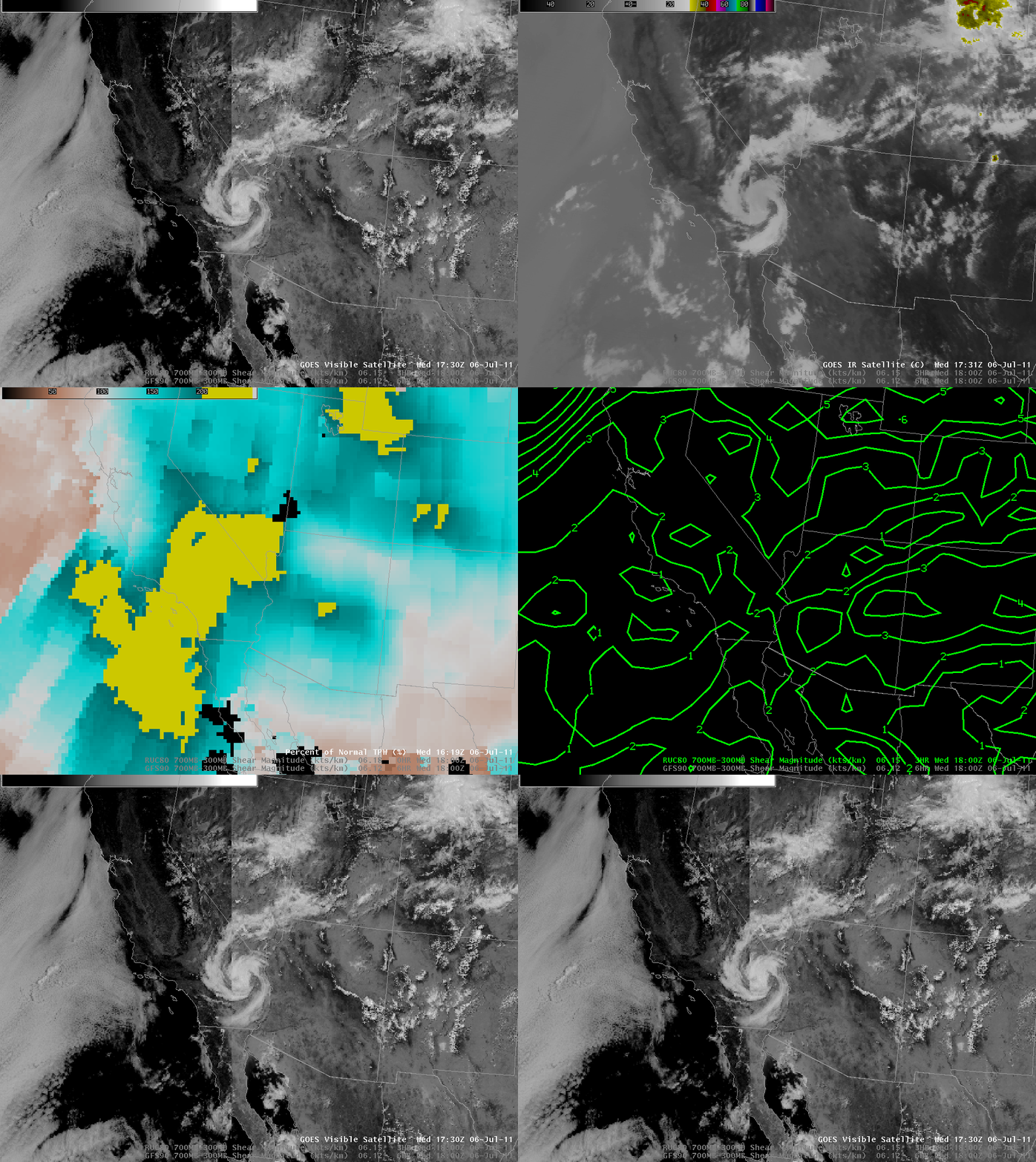
An AWIPS image comparison (above) shows GOES visible channel data (the seam in the middle of the images demarcates data from GOES-11 or GOES-West and GOES-13 or GOES-East; note that the older GOES-11 data is darker because of the age and degradation of that satellite’s visible sensors), GOES 10.7 µm IR channel data, the Blended Total Precipitable Water (TPW) Percent of Normal product, and 850-300 hPa layer wind shear from the GFS and RUC models. In the present example, the MCV exists in an axis of low values of 850-300 hPa wind shear, as noted by model forecasts from the RUC and from the GFS. Abnormally high values of precipitable water are also present, exceeding 200% of normal according to the ‘Blended Product’ that combines observations from the GOES Sounder and ground-based GPS stations. Rawinsonde reports from Phoenix (00 UTC and 12 UTC on 06 July) and from Yuma (12 UTC and 14 UTC on the 06 July) show abundant moisture and relatively low shear. All of these data show environmental conditions that support MCVs.
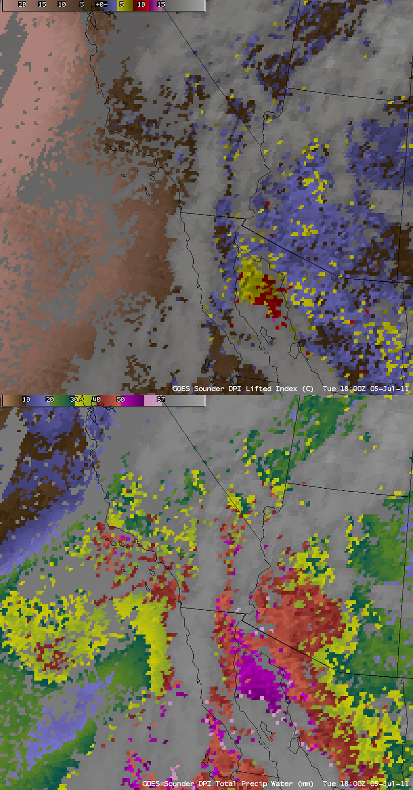
In the pre-convective environment across southern Arizona on 05 July, GOES-11 Sounder derived product images (above) showed Total Precipitable Water (TPW) values in the 40-50 mm (1.6 to 2.0 inch) range, and Lifted Index (LI) values as low as -5º to -8º C.
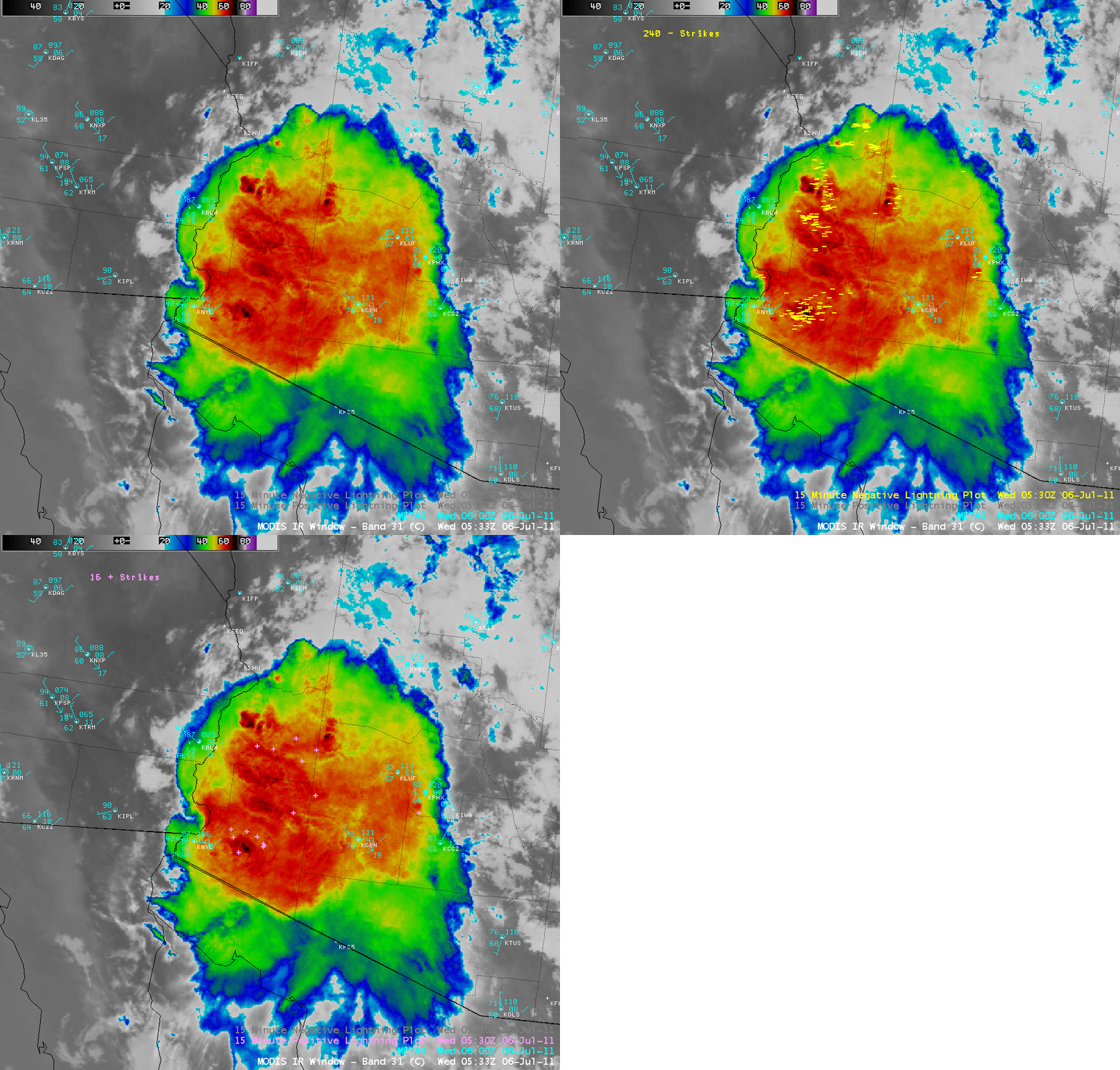
As the MCS continued to move westward across Arizona, an AWIPS image of 1-km resolution MODIS 11.0 µm IR data at 05:33 UTC (above) showed cloud top IR brightness temperatures as cold as -72º C (black color enhancement), along with numerous negative and positive cloud-to-ground lightning strikes. At that time, the thunderstorm outflow winds were moving through Blythe, California (station identifier KBLH) producing wind gusts of 46 knots (52 mph) with a reduction in visibility to 1.5 miles, and also through Yuma, Arizona (station identifier KNYL) producing wind gusts of 40 knots (46 mph) with a reduction in visibility to 1.25 miles.


