This website works best with a newer web browser such as Chrome, Firefox, Safari or Microsoft Edge. Internet Explorer is not supported by this website.

Mt. Redoubt volcanic eruption

The Mt. Redoubt volcano (located about 100 miles southwest of Anchorage, Alaska) produced a series of explosive eruptions beginning around 06:38 UTC on 23 March 2009. GOES-11 10.7 µm IR images (above) showed a few of the volcanic eruption clouds, which exhibited IR... Read More

GOES-11 10.7 µm IR images

GOES-11 10.7 µm IR images

The Mt. Redoubt volcano (located about 100 miles southwest of Anchorage, Alaska) produced a series of explosive eruptions beginning around 06:38 UTC on 23 March 2009. GOES-11 10.7 µm IR images (above) showed a few of the volcanic eruption clouds, which exhibited IR brightness temperature values of -50 to -58º C (yellow to red colors). Note that there was a 2 hour gap in the imagery, with no GOES-11 images available from 08:00 to 10:15 UTC — this was due to the fact that the GOES-11 satellite was in a “Spring eclipse” period, where the satellite was in the Earth’s shadow (and the solar panels could not generate the power necessary to operate the instruments).

AWIPS images of the “GOES IR Satellite” data (below) demonstrated that the substitution of GOES-12 (GOES-East) imagery during the GOES-11 (GOES-West) eclipse period did not allow the continual tracking of the volcanic plume features (the images with missing data and the jagged edges are from GOES-12).

AWIPS GOES-11 / GOES-12 IR images

AWIPS "GOES IR Satellite" images (GOES-11, with GOES-12 during eclipse)

The GOES-11 IR imagery indicated that most of the initial volcanic plumes headed toward the northeast, remaining to the north of Anchorage — but the plume from the later (and stronger) eruption that began after 12:30 UTC was seen to begin elongating and spreading out in more of a north-south direction, with the southern edge of that plume taking a path that appeared to be approaching Anchorage. Using AWIPS cursor sampling and referencing the 12:00 UTC Anchorage AK rawinsonde data, the coldest GOES-11 IR brightness temperature of -58º C corresponded to an altitude just over 30,000 feet — but the maximum height of the eruption cloud was reported to be as high as 50,000-60,000 feet above ground level. A number of Volcanic Ash Advisories were issued, and Alaska Airlines canceled 35 flights in and out of Anchorage International Airport as a precaution (since airborne volcanic ash is known to be a significant hazard to aviation).

The beginning phase of the later, stronger eruption that began around 12:30 UTC can be seen on MODIS imagery  (below). Note the cluster of very hot pixels on the 3.7 µm Channel 20 shortwave IR image (red color enhancement, temperatures as high as +57º C), which was a signature of the heat of the eruption at the summit of the volcano — in contrast, very cold IR brightness temperatures seen on the  11.0 µm Channel 31 IR image (as cold as -57º C, orange to red color enhancement) highlighted the portion of the volcanic eruption cloud that had reached very high altitudes in a very short time.

MODIS 3.7 µm and 11.0 µm IR images

MODIS 3.7 µm and 11.0 µm IR images

A sequence of 1-km resolution NOAA-15, NOAA-17 and NOAA-18 10.8 µm IR images (below) shows a few of the initial volcanic plume features (circled in cyan) at 4 different times  — 06:52 UTC, just after the initial eruption; 11:46 UTC, with an elongated plume which had drifted off to the northeast of Redoubt; 13:27 UTC, with a more dense plume feature that appeared to be spreading out in a NW-SE direction; and 14:30 UTC, showing another dense plume that had spread out even further in the N-S direction.

NOAA-15 / NOAA-17 / NOAA-18 10.8 µm IR images

NOAA-15 / NOAA-17 / NOAA-18 10.8 µm IR images

The volcanic plume could also be seen on imagery from the WSR-88D radar located near Kenai, Alaska (below). Surface ash falls of 1/8 to 1/4 inch were reported at Skwentna (northwest of Anchorage), and ash was reported on all airport surfaces at Talkeetna (north of Anchorage) — in fact, ash was reported on the ground as far north as Healy.

Kenai, Alaska radar composite reflectivity

Kenai, Alaska radar composite reflectivity

A 500-meter resolution MODIS “true color” Red/Green/Blue (RGB) composite image (below) shows a signature of ash fall  on top of the pristine white snow cover of the Alaska Range (as denoted by the lighter brown tint). A higher resolution version is available from the Alaska Volcano Observatory.

MODIS true color RGB composite image

MODIS "true color" RGB composite image

===== 24 MARCH UPDATE =====

(courtesy of Mike Pavolonis, NOAA/NESDIS/ASPB)

Shown below are some AVHRR ash retrievals (ash concentration, ash height, and ash effective particle radius) from the 23-24 March eruptions.  All of these AVHRR products will be produced operationally by NOAA/NESDIS starting sometime next Spring (2010).  Ash shows up as red in the accompanying false color images (upper left panels).  Notice that the retrieved ash particle sizes are fairly large (mean effective radius of 7-10 micron).  This may be one of the reasons that the 11 – 12 micron brightness temperature difference (BTD) signal was “weak”  (very few negative BTD’s were present in the imagery).  The presence of larger ash particles may also speak to the relatively quick dissipation of the visible ash cloud as seen in the imagery.  Of course multi-layered meteorological clouds complicate matters further.  Our retrieval takes into account the lower level meteorological clouds (limited by certain assumptions), but the complicated nature of the scene still results in additional uncertainty.

Nevertheless, the results indicate that the largest amount of ash (only including ash that is not obscured by higher level hydrometeors), 155 kilo-tons, was seen after the 7:41 PM AKDT eruption on March 23 (03:41 UTC on March 24).  We estimated the maximum height of the ash-dominated portion of the various volcanic clouds to be around 8-km, which is about 1 km shy of the Anchorage tropopause.  The ice/SO2 dominated portion of the cloud likely went much higher.

4-panel of volcanic ash products (23 March 11:46 UTC)

AVHRR volcanic ash retrieval products -- 23 March 11:46 UTC

=================================================

4-panel of volcanic ash products (23 March 13:27 UTC)

AVHRR volcanic ash retrieval products -- 23 March 13:27 UTC

=================================================

4-panel of volcanic ash products (24 March 06:33 UTC)

AVHRR volcanic ash retrieval products -- 24 March 06:33 UTC

===== 26 MARCH UPDATE =====

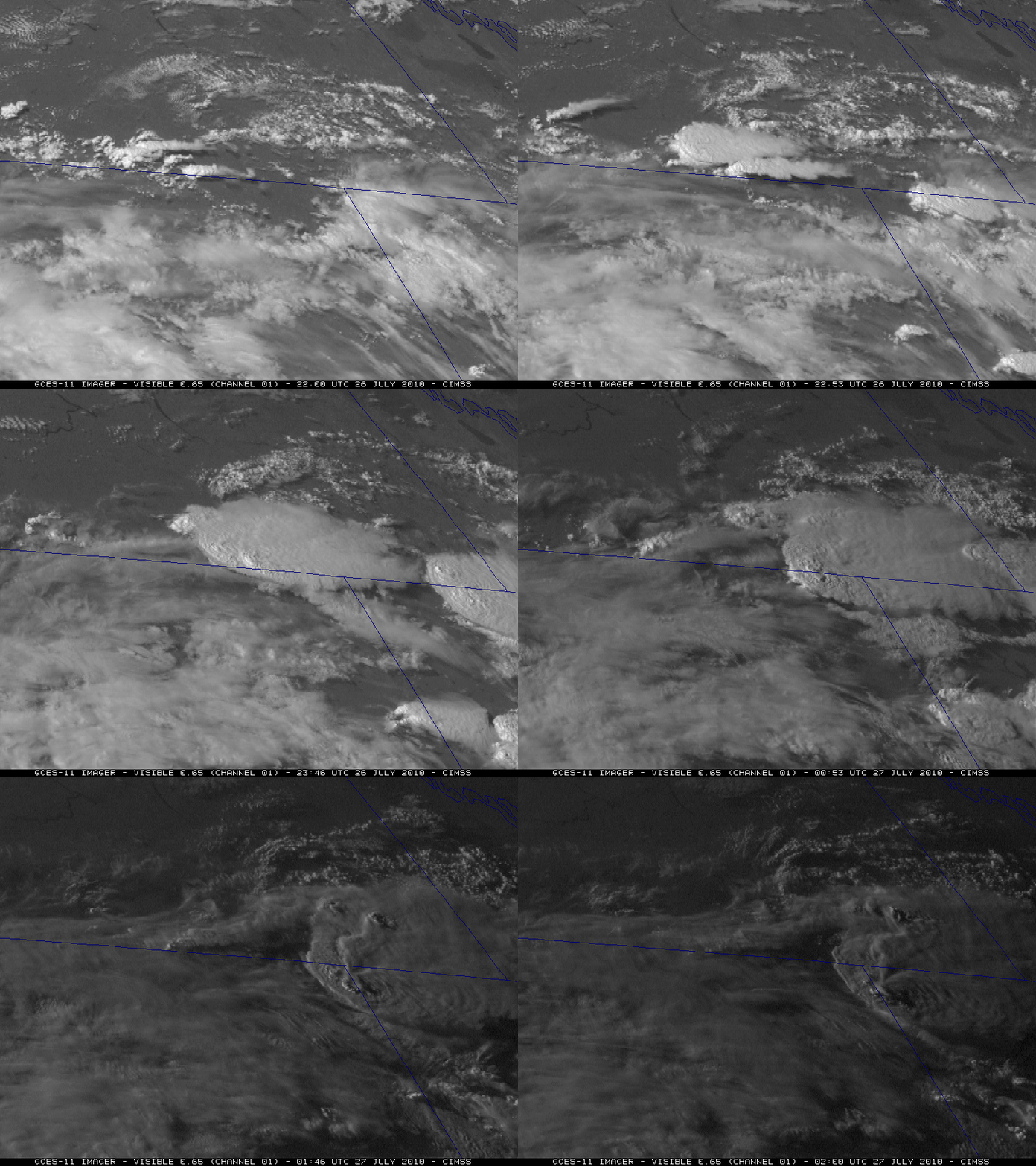
Another explosive eruption of the Mt. Redoubt volcano occurred around 17:24 UTC on 26 March 2009, sending ash to an estimated 65,000 feet. GOES-11 visible images (below) show the volcanic eruption cloud.

GOES-11 visible images

GOES-11 visible images

The large viewing angle from the MTSAT-1R satellite offered a nice depiction of the initial volcanic eruption plume (below).

MTSAT-1R visible images

MTSAT-1R visible images

Using a GOES-11 Sounder IR difference product — Band 10 (7.4 µm) minus Band 5 (13.3 µm) –  that is sensitive to SO2, one can follow the signature of an SO2 plume (darker black filaments) as it moved southward from British Columbia in Canada over the Intermountain West region of the US (below).

GOES-11 Sounder IR difference product (Band 10 - Band 5)

GOES-11 Sounder IR difference product (Band 10 - Band 5)

===== 27 MARCH UPDATE =====

MODIS Band 26 near-IR (1.3µm) data can be used to detect particles that are good scatterers of light (such as cirrus ice crystals, airborne dust/haze/ash, etc); such scattering particles will exhibit a “brighter” signal on greyscale MODIS “cirrus detection” images. On 2 consecutive overpasses of the MODIS instrument (on Terra at 18:21 UTC, and on Aqua at 19:59 UTC) there was a subtle signal of an elevated volcanic plume that was oriented SW-NE across Iowa, southern Wisconsin, and far northern Illinois  during the day on 27 March 2009 — this plume originated from one of the eruptions of the Redoubt volcano in Alaska a few days earlier. Ground-based lidar at the Space Science and Engineering Center (University of Wisconsin – Madison) depicted enhanced aerosol backscatter aloft, with multiple layers seen between 11-13 km around the time of the 2 MODIS images (below).

MODIS 1.3 µm cirrus detection images + SSEC lidar backscatter

MODIS 1.3 µm "cirrus detection" images + SSEC lidar aerosol backscatter

Taking advantage of the large “forward scattering angle” of GOES-12 imagery late in the day, the volcanic plume could also be seen as a hazy feature on the visible channel imagery (below).

GOES-12 visible imagery

GOES-12 visible imagery

Related links:

View only this post Read Less

Short-term predictions of convective development

The 10 February 2009 tornado outbreak was noteworthy for the production of strong supercells in and around metropolitan Oklahoma City at a time of year when climatology argues against their presence. This tornado outbreak has been discussed previously on this blog, which includes visible and infrared satellite animations as well as TPW, LI and ozone products from the GOES sounder. The present blog entry discusses a... Read More

The 10 February 2009 tornado outbreak was noteworthy for the production of strong supercells in and around metropolitan Oklahoma City at a time of year when climatology argues against their presence. This tornado outbreak has been discussed previously on this blog, which includes visible and infrared satellite animations as well as TPW, LI and ozone products from the GOES sounder. The present blog entry discusses a sequence of multi-layer stability observations and short-range forecasts obtained from GOES sounder precipitable water products.

Convective outlooks issued by the Storm Prediction Center had the highest probability of severe weather in southeast Oklahoma. Storm reports, however, show a region of less concentrated severe weather within the region of moderate risk (centered near Texarkana, AR) as well as a a concentrated region of severe weather outside the initial moderate risk area (but still within the slight risk region). A 1630z update did expand the area of moderate risk to the northwest, to include the region where supercells and tornadoes occurred.

Information from the GOES-12 sounder Water Vapor channels helps to define the regions most susceptible to convection on that day, as shown in the loop above. This technique initializes a trajectory model with RUC winds and with precipitable water at different levels as retrieved from the GOES-12 sounder. The retrieval uses the 3 water vapor channels, channels 10 (7.4 microns), 11 (7.0 microns) and 12 (6.5 microns). (The shorter wavelength energy typically is emitted from higher in the atmosphere. GOES-12 weighting functions from Channel 10 typically peak around 600 or 700 mb; weighting functions from Channel 12 peak closer to 400 mb. (The exact level is, of course, a function of the airmass and the satellite viewing angle)). These three channels can help to define the distribution of water vapor in the atmosphere at different levels: the output of the retrieval that combines the brightness temperatures and initial guess soundings is precipitable water (mm) at different levels. Such a multi-layer description of the atmospheric water vapor is not possible with the single water vapor channel on the GOES imager; the multiple channels of the GOES sounder are required.

This model can predict areas of destabilization (convective potential) if “low” level moisture moves underneath “upper” level drying. The fields are presented as moisture change with height. If a region shows the moisture change with height increasing with time, then that region is becoming more convectively unstable. In the case shown above, observations are shown for the 6 hours before the ‘initial’ model time (17 UTC), and then output from the model — that is, short-range predictions (nearcasts) from a model using RUC winds and GOES Sounder PWs — is shown. Maximum destabilization is clearly indicated over central Oklahoma where supercells and tornadoes occurred. Note that for the 10 February case, the region of most interest aligns favorably with the line of convective development that initiated over central TX and central OK and produced supercell thunderstorms in the metro Oklahoma City area. In addition, the peak instability — as defined by the greatest decrease in precipitable water with height — occurs around 2100 UTC. Here is a radar image from that time. The predictions started from data at 1400 UTC, 1500 UTC, 1600 UTC, 1700 UTC (as above), 1800 UTC, 1900 UTC, 2000 UTC, 2100 UTC and 2200 UTC all show similar patterns. Note also that southeastern OK, also within the moderate risk, is diagnosed with somewhat less destabilization using this technique.

A second technique for discerning convective potential from satellite is discussed here.

View only this post Read Less
Undular bore in Florida

GOES-13 visible imagery (above) showed  an undular bore that was propagating southward across the Florida peninsula  on 17 March 2009. This bore feature appeared to play a role in the initiation of a line of convective clouds that developed over central and... Read More

GOES-13 visible images

GOES-13 visible images

GOES-13 visible imagery (above) showed  an undular bore that was propagating southward across the Florida peninsula  on 17 March 2009. This bore feature appeared to play a role in the initiation of a line of convective clouds that developed over central and southern Florida after about 15 UTC (10am local time). The resulting precipitation was farily light, however, with rainfall amounts of 0.10 inch or less.

A MODIS true color image (below, displayed using Google Earth) revealed that there were at least 10 individual cloud bands (also known as “solitons”) associated with this undular bore. The fact that this particular bore feature appeared to help with convective initiation might seem counter-intuitive, given that the propagation of bores requires a stable layer to propagate — but the convection may have fired along the leading edge of the cold frontal boundary (which was likely out ahead of the undular bore).

MODIS true color image

MODIS true color image (viewed using Google Earth)

The photo below shows the leading edge of the undular bore clouds (taken just south of Melbourne, along the coast, around 9:00 am local time).

Photograph of bore clouds (courtesy of , UW-Madison)

Photograph of bore clouds (courtesy of Dan Hartung (UW-Madison/AOS student)

View only this post Read Less
Stratospheric intrusion vorticies

Water vapor imagery from the GOES-11, GOES-12, and GOES-13 satellites (above) showed the spin-up of a well-defined “stratospheric intrusion vortex” over western Kansas on 14 March 2009. The imagery from each of those 3 satellites is displayed in its native projection, which... Read More

GOES-11 / GOES-12 / GOES-13 waver vapor images

GOES-11 / GOES-12 / GOES-13 waver vapor images

Water vapor imagery from the GOES-11, GOES-12, and GOES-13 satellites (above) showed the spin-up of a well-defined “stratospheric intrusion vortex” over western Kansas on 14 March 2009. The imagery from each of those 3 satellites is displayed in its native projection, which helps to demonstrate the difference that satellite viewing angle has on the depiction of features on the water vapor imagery. Also demonstrated is the fact that imagery from GOES-13 was available through the GOES-11 and GOES-12 “Spring eclipse” periods (when the geostationary satellites are in the Earth’s shadow, and their solar panels cannot generate the power necessary to operate the instruments) — larger batteries on-board the GOES-13 satellite allows operation through the Spring and Fall eclipse periods.

A larger-scale view of AWIPS GOES-12 water vapor imagery (below) shows that there was a string of these vorticies forming during the 14-15 March time period, with a pair of smaller, weaker features seen in Iowa. While these stratospheric intrusion vorticies are seen on water vapor imagery from time to time, they usually do not produce much in the way of “sensible weather” (clouds or precipitation). However, they do seem to be capable of producing areas of mid-tropospheric turbulence, which can be a hazard for aviation. Pilot reports of turbulence (below) did show that there were a few scattered reports of light to moderate turbulence in the general vicinity of the vorticies.

GOES-12 water vapor images + pilot reports of turbulence

GOES-12 water vapor images + pilot reports of turbulence

The GOES-12 sounder Total Column Ozone derived product (below) confirms that these water vapor features were indeed stratospheric intrusion vorticies — the warmer/drier water vapor vortex features  corresponded to ozone values in the 375-400 Dobson Unit range (brighter green to red color enhancement).

GOES sounder Total Column Ozone derived product

GOES sounder Total Column Ozone derived product

The largest and most well-defined vortex (which initially formed over western Kansas on 14 March) was fairly long-lived, and was still evident on water vapor imagery over Illinois 48 hours later on 16 March. Surprisingly, this vortex also spawned some small pockets of convection that even produced a handful of cloud to ground lightning strikes (below).

GOES-12 water vapor images + lightnining strikes

GOES-12 water vapor images + lightnining strikes

A GOES-12 water vapor image with an overlay of NAM40 model fields of 500 hPa height (cyan contours) and PV1.5 pressure (red contours) indicated that there was a Potential Vorticity (PV) anomaly associated with the stratospheric intrusion vortex — the height of the “dynamic tropopause” (taken to be the pressure of the PV1.5 surface) was brought downward to near the 500 hPa pressure level over parts of northern Missouri and central Illinois.

GOES-12 water vapor image (with location of NAM40 cross section line)

GOES-12 water vapor image (with location of NAM40 cross section line)

An AWIPS cross section of the NAM40 model fields (below) allows another way to visualize the lowering of the dynamic tropopause with this PV anomaly (PV is depicted as the multi-colored image feature on the cross section).

Cross section of NAM40 model fields

West-to-east cross section of NAM40 model fields

View only this post Read Less