A major winter storm impacted parts of the Upper Midwest region on 13 November 2010, producing snowfall amounts as high as 14 inches at Emmetsburg, Iowa, 12.0 inches at Maple Grove, Minnesota (NWS MPX story), and 11.0 inches at Hawthorne, Wisconsin (NWS DLH story).AWIPS images of 4-km resolution GOES-13 6.5 µm “water vapor channel” data (above)... Read More

GOES-13 6.5 µm "water vapor channel" images + cloud-to-ground lightning strikes
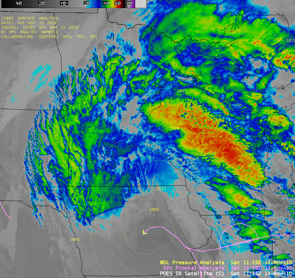
A major winter storm impacted parts of the Upper Midwest region on 13 November 2010, producing snowfall amounts as high as 14 inches at Emmetsburg, Iowa, 12.0 inches at Maple Grove, Minnesota (NWS MPX story), and 11.0 inches at Hawthorne, Wisconsin (NWS DLH story).
AWIPS images of 4-km resolution GOES-13 6.5 µm “water vapor channel” data (above) revealed a pronounced middle-tropospheric dry slot wrapping into the eastern sector of the storm. Thundersnow was reported at a few locations — note that there were a few cloud-to-ground lightning strikes showing up near the leading edge of the dry slot (over western Iowa after 05:15 UTC, and then over southern Minnesota after 12:15 UTC).
The corresponding 4-km resolution GOES-13 10.7 µm “IR window channel” images (below) showed that the cloud top IR brightness temperatures were not particularly cold across the areas that received the heavy snow (generally in the -30 to -40º C range, dark blue to green color enhancement), though there were bands exhibiting much colder cloud tops (colder than -60º C, red color enhancement) farther to the east within the warm conveyor belt of the storm.

GOES-13 10.7 µm "IR window channel" images + cloud-to-ground lightning strikes
A more detailed view of the storm’s cloud structures could be seen by examining a series of 1-km resolution MODIS 11.0 µm and POES AVHRR 10.8 µm “IR window channel” images (below). An overlay of the 12 UTC HPC-analyzed surface fronts and surface pressure on the 11:16 UTC POES AVHRR IR image showed that the center of the storm system was located over central Iowa at that time.

MODIS 11.0 µm and POES AVHRR 10.8 µm "IR window channel" images
A 1-km resolution MODIS false-color Red/Green/Blue (RGB) image (below) showed the beginning portion of the heavy snow swath, which was stretching from southeastern Nebraska (where as much as 4.0 inches was reported at Gretna) into southwestern Iowa as the main cloud deck associated with the storm system began clear out over that region. In this false-color RGB image (created using the MODIS 0.65 µm “visible channel” image as the Red, and the MODIS 2.1 µm “snow/ice channel” image as the Green and Blue components), the deeper snow cover shows up as the darker red features.
 image")
MODIS false-color Red/Green/Blue (RGB) image
========== 15 NOVEMBER UPDATE ==========
There was enough of a break in the clouds on 15 November to get a nice view of the southern portion of the swath of snow cover that stretched from Iowa into southern Minnesota — on the comparison of MODIS false-color RGB images at 17:35 UTC and 19:17 UTCÂ (below), the snow cover again appears as the darker red feature (in contrast to the brighter supercooled water droplet clouds, and the lighter pink ice crystal clouds).
 images")
MODIS false-color Red/Green/Blue (RGB) images
View only this post
Read Less

 image")


 image")

