A fissure eruption on the Kilauea volcano on the island of Hawaii began on 05 March 2011 — and 3 days later, McIDAS images of GOES-11 3.9 µm shortwave IR data (above; click image to play animation) displayed a prominent “hot spot” (yellow to red enhanced pixels) during the day... Read More
")
GOES-11 3.9 µm shortwave IR images (click image to play animation)
A fissure eruption on the Kilauea volcano on the island of Hawaii began on 05 March 2011 — and 3 days later, McIDAS images of GOES-11 3.9 µm shortwave IR data (above; click image to play animation) displayed a prominent “hot spot” (yellow to red enhanced pixels) during the day on 08 March 2011.
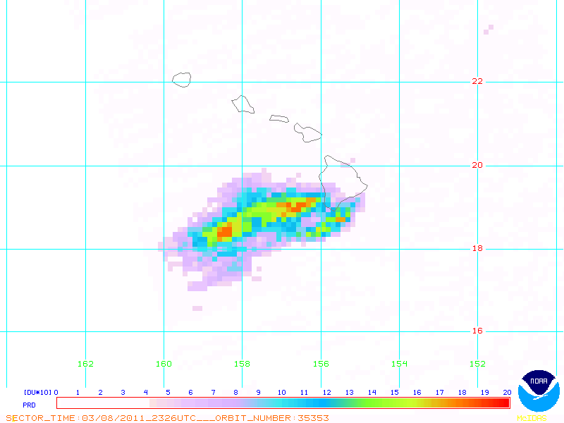
GOES-11 0.65 µm visible images (below; click image to play animation) showed the hazy summit plume spreading southwestward during the day. This volcanic plume contained high levels of sulphur dioxide (SO2), as seen on an image of OMI total column SO2 (courtesy of NOAA/NESDIS).
")
GOES-11 0.65 µm visible images (click image to play animation)
About 3000 miles (4800 km ) to the north, GOES-11 0.65 µm visible images (below; click image to play animation) showed the movement of ice in the Bering Sea west of Alaska. Note that the motion of the ice was toward the northeast early in the animation, but then changed to motion toward the southwest later in the day. Surface winds along with tidal currents in the Bering Sea have an influence on the overall motion of the ice.
")
GOES-11 0.65 µm visible images (click image to play animation)
The motion of the ice in the Bering Sea could also be seen on a sequence of AWIPS images of POES AVHRR 0.86 µm visible channel data (below).

POES AVHRR 0.86 µm visible images
The POES AVHRR Sea Surface Temperature (SST) product (below) indicated that SST values were in the low to middle 30f F (darker blue color enhancement) in the ice-free water south and west of the ice edge.

POES AVHRR Sea Surface Temperature product
View only this post
Read Less

")
")


")
")
")


