
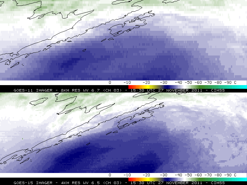
Using GOES-11 vs GOES-15 as the source for GOES-West water vapor channel images
GOES-15 is scheduled to replace GOES-11 as the operational GOES-West satellite on 06 December 2011. On 29 November 2011, a test was conducted by NOAA/NESDIS which briefly substituted GOES-15 data for GOES-11 data as the source of GOES-West satellite imagery in AWIPS. In the sequence of AWIPS images shown above, the first 3 images are using GOES-11, while the final set of 3 images are using GOES-15 as the source for GOES-West Imager water vapor channel data. The changes to the GOES-15 Imager water vapor channel are quite obvious — GOES-15 uses a 4-km resolution channel centered at 6.5 µm that has a wider spectral response, compared to the 8-km resolution 6.7 µm channel with a more narrow spectral response on GOES-11. Even at high latitudes (where the large satellite viewing angle shifts the GOES water vapor weighting function to higher altitudes) the improved GOES-15 water vapor channel imagery will do a better job of depicting the moisture gradients and structure associated with mid-tropospheric dynamical features (Gulf of Alaska example | Nunavut, Canada example).
A similar comparison using GOES-11 (the first 3 images) vs GOES-15 (the final set of 3 images) Imager visible channel data is seen below. Immediately obvious is the fact that the GOES-15 visible channel imagery appears “brighter” than the GOES-11 visible channel imagery — this is due to the fact that the performance of the GOES visible detectors degrades over time (GOES-11 was launched in 2000, and became the operational GOES-West satellite in 2006). The 0.63 µm visible channel on GOES-15 is also slightly different than the 0.65 µm visible channel on GOES-11, as is discussed in the “GOES-13 is now the operational GOES-East satellite” blog post. GOES-15 is similar to GOES-13, since it is part of the GOES-N/O/P series of spacecraft.

Using GOES-11 vs GOES-15 as the source for GOES-West visible channel images
Finally, below is a comparison of GOES Sounder data, using GOES-11 as the source of GOES-West 6.5 µm Sounder water vapor channel data (the first 2 images) vs GOES-15 (the final set of 2 images). Note that the GOES-15 Sounder water vapor channel imagery has less noise than that from GOES-11.

Using GOES-11 vs GOES-15 as the source for GOES-West Sounder water vapor channel images
View only this post Read Less
")
")
 image")


 true color image")
 true color image")
 true color image")
