This website works best with a newer web browser such as Chrome, Firefox, Safari or Microsoft Edge. Internet Explorer is not supported by this website.

Mesoscale Convective Vortex (MCV) in southern California

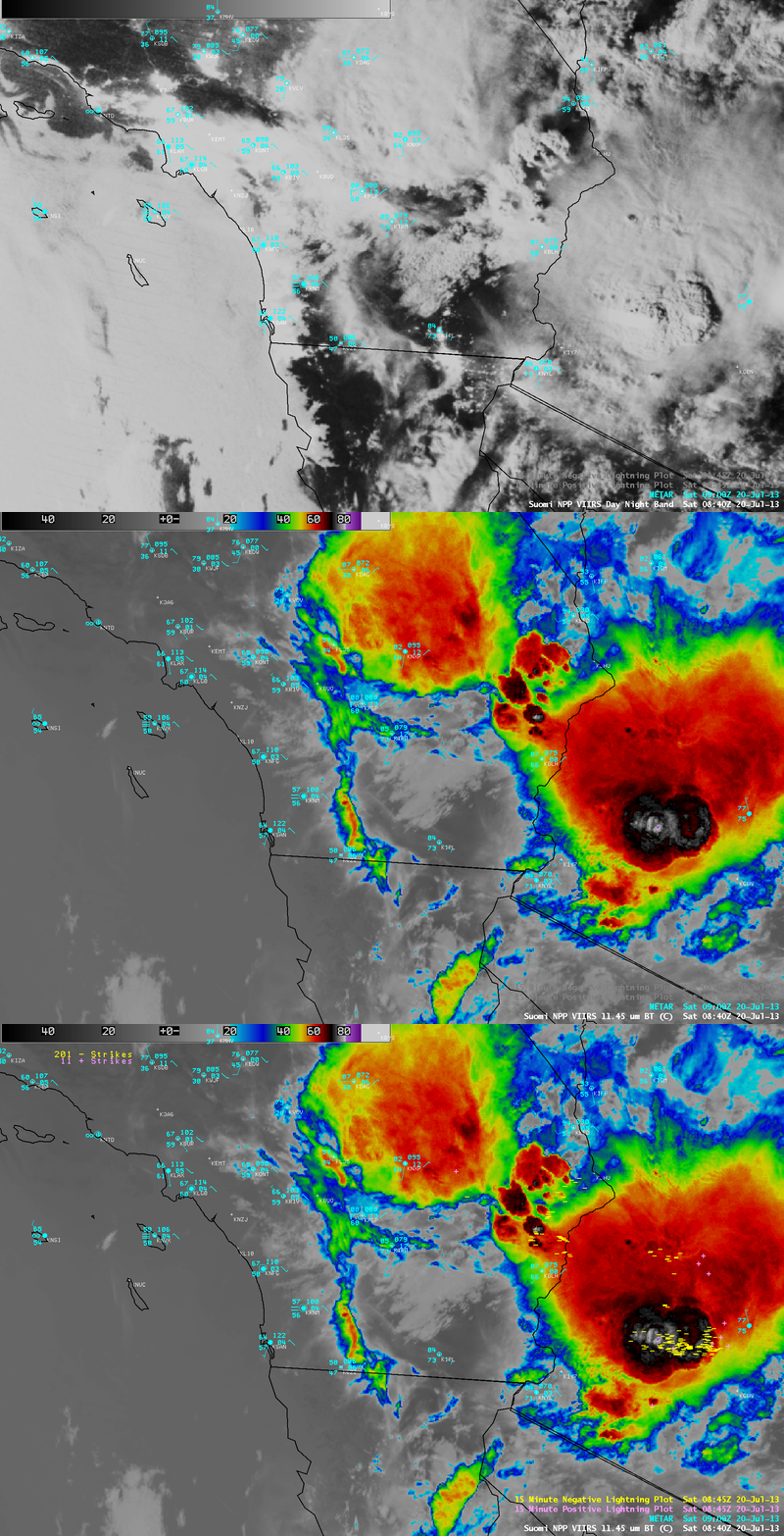
A comparison of AWIPS images of Suomi NPP VIIRS 0.7 µm Day/Night Band and 11.45 µm IR channel data (above) showed a large mesoscale convective system in southwestern Arizona at 08:40 UTC or 2:40 am local time on 20 July 2013. With ample... Read More

Suomi NPP VIIRS 0,7 µm Day/Night Band and 11.45 µm IR channel images

Suomi NPP VIIRS 0,7 µm Day/Night Band and 11.45 µm IR channel images

A comparison of AWIPS images of Suomi NPP VIIRS 0.7 µm Day/Night Band and 11.45 µm IR channel data (above) showed a large mesoscale convective system in southwestern Arizona at 08:40 UTC or 2:40 am local time on 20 July 2013. With ample illumination from the Moon (which was in the Waxing Gibbous phase, at 96% of full), the “visible image at night” capability of the VIIRS Day/Night Band image allowed shadowing from overshooting thunderstorm tops to be clearly seen; the coldest cloud-top IR brightness temperature of the overshooting tops was -83º C (violet color enhancement). In addition, numerous cloud-to-ground lightning strikes were associated with the MCS at that time. A few hours earlier, this storm had produced reports of wind damage in the Phoenix area just after 05 UTC (SPC Storm Reports).

With the arrival of daylight, McIDAS images of GOES-15 (GOES-West) 0.63 µm visible channel data (below; click image to play animation) revealed the emergence of a well-defined and relatively compact Mesoscale Convective Vortex (MCV) that continued to move westward across southern California during the day. The MCV also played a role in helping to iniitate additional convection in areas such as the San Bernadino Mountains of southern California.

GOES-15 0.63 µm visible channel images (click image to play animation)

GOES-15 0.63 µm visible channel images (click image to play animation)

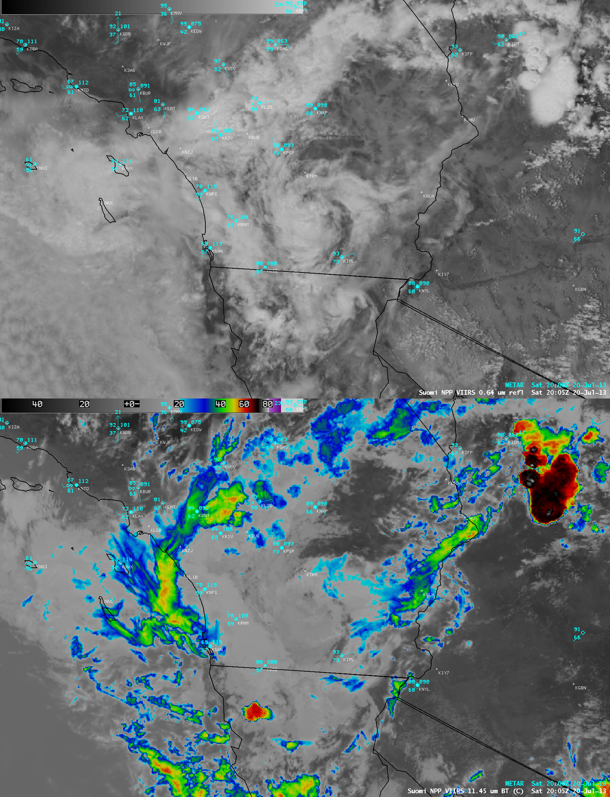
A comparison of Suomi NPP VIIRS 0.64 µm visible channel and 11.45 µm IR channel images at 20:05 UTC (below) showed that the clouds associated with the MCV were primarily low to mid-level clouds, which exhibited IR brightness temperatures that were generally warmer than -20º C.

Suomi NPP VIIRS 0.64 µm visible channel and 11.45 µm IR channel images

Suomi NPP VIIRS 0.64 µm visible channel and 11.45 µm IR channel images

For aditional information on MCVs, see the VISIT lesson “Mesoscale Convective Vortices“. For additional information on VIIRS imagery, see the VISIT lesson “VIIRS Satellite Imagery in AWIPS“.

View only this post Read Less

“Midget” tropical cyclone over the West Pacific Ocean?

A sequence of MTSAT-2 0.675 µm visible channel images (during daytime) and 10.8 µm IR channel images (during the night) revealed the signature of what could be a “midget” tropical cyclone which was moving westward across the western Pacific Ocean during the 17 July – 19 July period (above; click... Read More

MTSAT-2 visible (daytime) and IR (night-time) images

MTSAT-2 visible (daytime) and IR (night-time) images

A sequence of MTSAT-2 0.675 µm visible channel images (during daytime) and 10.8 µm IR channel images (during the night) revealed the signature of what could be a “midget” tropical cyclone which was moving westward across the western Pacific Ocean during the 17 July – 19 July period (above; click image to play animation).

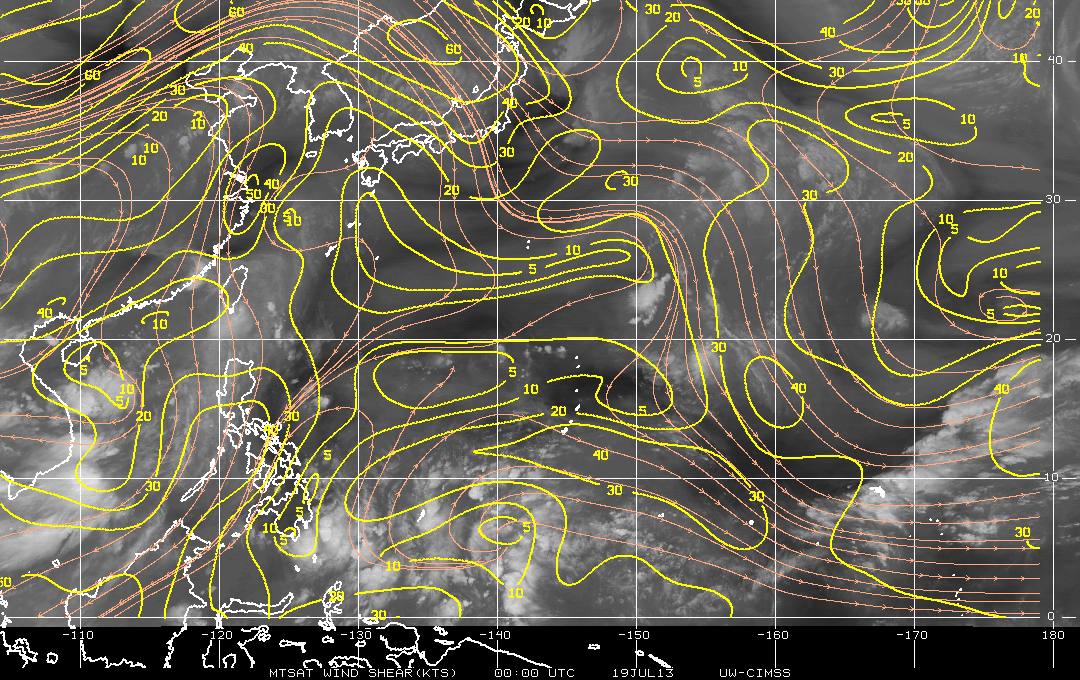
MTSAT-2 6.75 µm water vapor channel images with overlays of satellite wind derived deep-layer wind shear from the CIMSS Tropical Cyclones site (below; click image to play animation) showed that the region near 21º North latitude 130º East longitude was experiencing generally light to moderate northeasterly wind shear during this time period.

MTSAT-2 water vapor images + deep layer wind shear

MTSAT-2 water vapor images + deep layer wind shear

View only this post Read Less

Record rainfall in San Juan, Puerto Rico

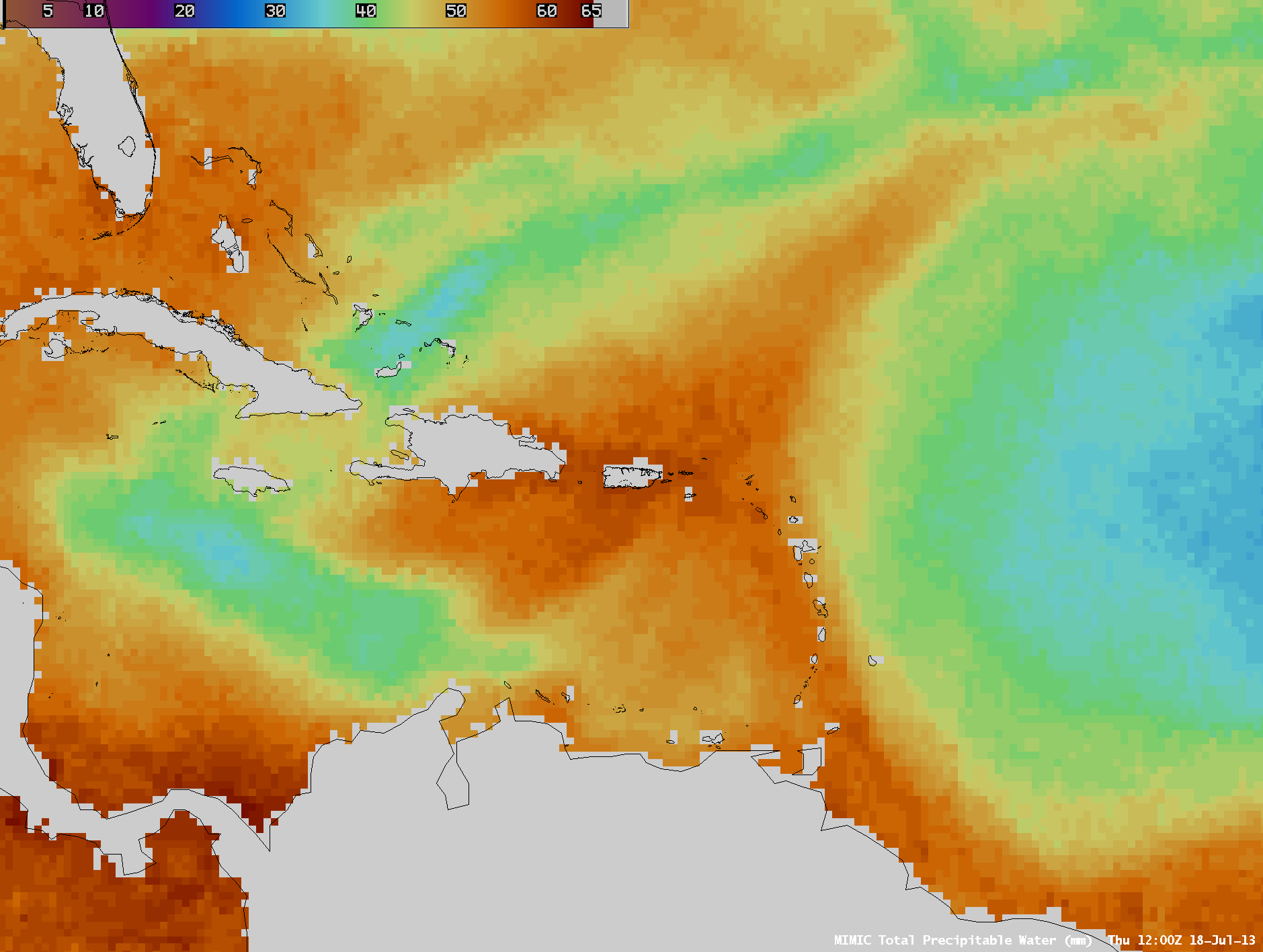
Abundant moisture associated with a strong tropical wave (18 UTC surface analysis) fueled strong thunderstorms which produced record-setting rainfall at San Juan, Puerto Rico on 18 July 2013. AWIPS images of the MIMIC Total Precipitable Water... Read More

MIMIC Total Precipitable Water product (click image to play animation)

MIMIC Total Precipitable Water product (click image to play animation)

Abundant moisture associated with a strong tropical wave (18 UTC surface analysis) fueled strong thunderstorms which produced record-setting rainfall at San Juan, Puerto Rico on 18 July 2013. AWIPS images of the MIMIC Total Precipitable Water (TPW) product (above; click image to play animation) showed the westward motion of the tropical wave, which exhibited TPW values greater than 50 mm or 2.0 inches (darker orange color enhancement) over a broad area — in fact, TPW values in the vicinity of Puerto Rico reached 60 mm or 2.4 inches on 18 July. Much drier air with significantly lower TPW values (30-35 mm or 1.2-1.4 inches, cyan to darker blue color enhancement) followed in the wake of the tropical wave passage; this dry air was likely the leading edge of a westward pulse of the Saharan Air Layer or SAL (real-time SAL images).

McIDAS images of 4-km resolution GOES-13 10.7 µm IR channel data (below; click image to play animation) showed numerous clusters of thunderstorms with very cold cloud top IR temperatures — IR brightness temperature values were as cold as -82º C (violet color enhancement) at 17:10 UTC.The location of San Juan is marked by the ‘*‘ symbol on the images.The GOES-13 satellite had been placed into Rapid Scan Operations (RSO) mode, providing images as frequently as every 5-10 minutes.

GOES-13 10.7 µm IR channel images (click image to play animation)

GOES-13 10.7 µm IR channel images (click image to play animation)

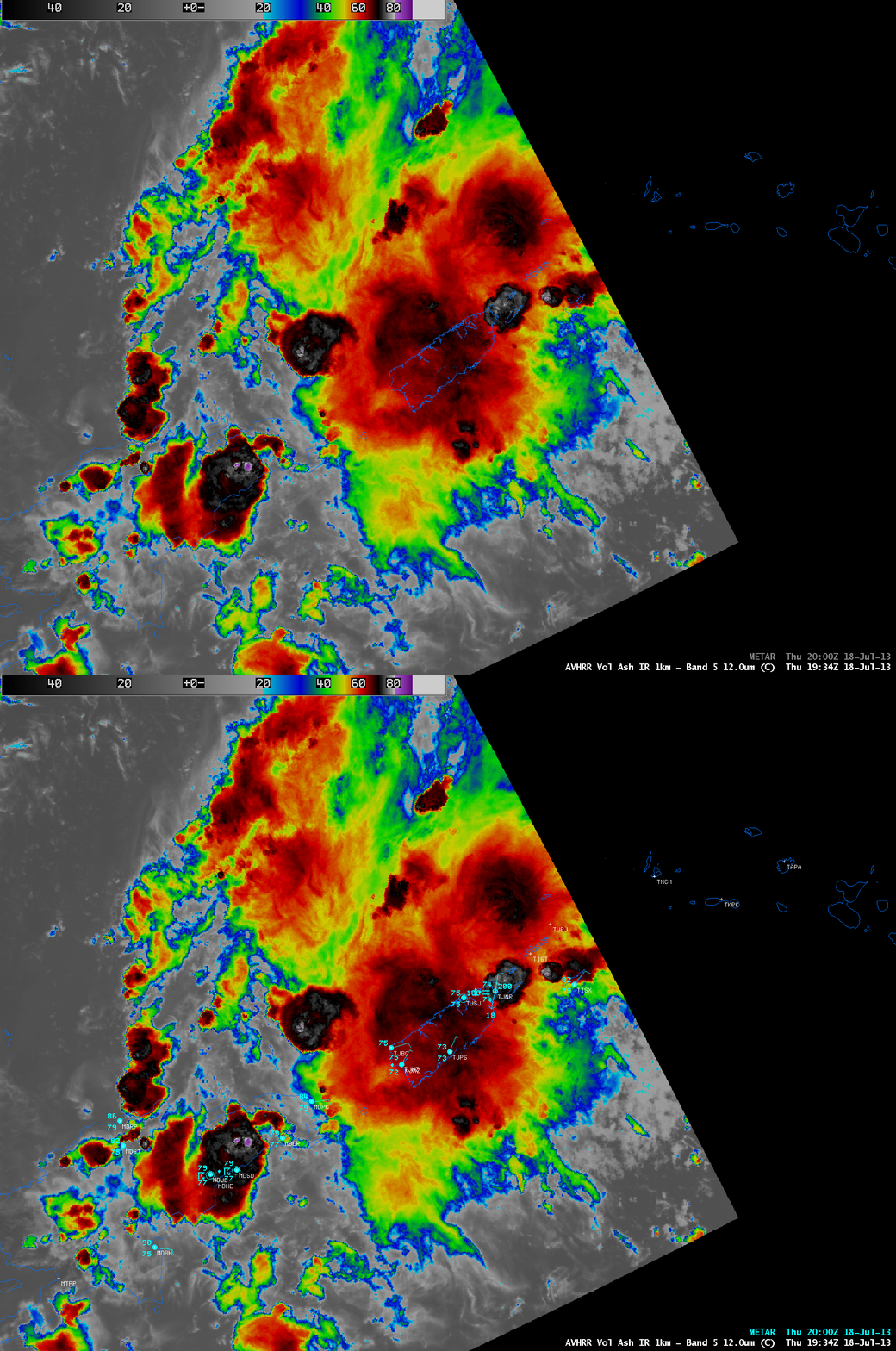
A 1-km resolution POES AVHRR 12.0 µm IR image (below) showed a strong thunderstorm beginning to move over the far eastern end of Puerto Rico at 19:35 UTC.

POES AVHRR 12.0 µm IR image (with METAR surface reports)

POES AVHRR 12.0 µm IR image (with METAR surface reports)

View only this post Read Less

Eruption of the Tungurahua volcano in Ecuador

Tungurahua is an active stratovolcano in Ecuador (Wikipedia); a Landsat-8 false-color image showed the partially snow-covered dome of the volcano on 13 July 2013. On the following day, the Washington Volcanic Ash Advisory Center issued a Read More

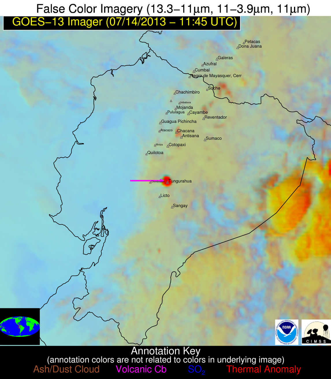
GOES-13 false-color Red/Green/Blue (RGB) image

GOES-13 false-color Red/Green/Blue (RGB) image

Tungurahua is an active stratovolcano in Ecuador (Wikipedia); a Landsat-8 false-color image showed the partially snow-covered dome of the volcano on 13 July 2013. On the following day, the Washington Volcanic Ash Advisory Center issued a volcanic ash advisory due to an explosive eruption that occurred at 11:51 UTC on 14 July 2013. A GOES-13 false-color Red/Green/Blue (RGB) image created using the NOAA/CIMSS GOES-R Volcanic Ash Detection Algorithm (above) highlighted a warm thermal anomaly and a volcanic cumulonimbus (based upon very rapid cloud top cooling rates and cold IR brightnesss temperature values) minutes after the eruption began — during the “11:45 UTC” GOES-13 image, the satellite was actually scanning the region of the volcanic eruption at 11:58 UTC.

GOES-15 (left), GOES-12 (center), and GOES-13 (right) visible images

GOES-15 (left), GOES-12 (center), and GOES-13 (right) visible images

A comparison of the early stages of the volcanic cloud as viewed from GOES-15 (GOES-West), GOES-12 (GOES-South America), and GOES-13 (GOES-East) is shown with visible channel images (above) and IR channel images (below). The actual times that each of the satellites were scaning the region of the volcanic eruption are noted in the labels, and the images are shown in the native projection for each individual satellite.

The GOES-13 satellite was the first to detect to volcanic cloud, since it was scanning the area at 11:58 UTC (about 7 minutes after the beginning of the eruption). The oblique viewing angle from the GOES-15 satellite helped to highlight the darker gray appearance of the ash-laden volcanic cloud, and reveal the long shadow being cast to the west of the tall feature (estimated to be as high as 45,000 feet above ground level). The volcanic cloud appeared largest on the GOES-12 images due to the more direct viewing angle, as well as the later scan time.

GOES-15 (left), GOES-12 (center), and GOES-13 (right) IR images

GOES-15 (left), GOES-12 (center), and GOES-13 (right) IR images

Animations depicting the volcanic cloud evolution are shown using GOES-12 0.65 µm visible channel, 6.5 µm water vapor channel, and 10.7 µm “IR window” channel images (below). Since a large amount of water vapor is usually exhaled during such explosive eruptions, the extent of the volcanic cloud can be more easily followed on the water vapor channel images.

GOES-12 0.65 µm visible channel images (click image to play animation)

GOES-12 0.65 µm visible channel images (click image to play animation)

GOES-12 6.5 µm water vapor channel images (click image to play animation)

GOES-12 6.5 µm water vapor channel images (click image to play animation)

GOES-12 10.7 µm IR channel images (click image to play animation)

GOES-12 10.7 µm IR channel images (click image to play animation)

View only this post Read Less