![GOES-14 Visible (0.63 µm) images, 1-minute time-step [click to play rocking animated gif]](https://cimss.ssec.wisc.edu/satellite-blog/wp-content/uploads/sites/5/2016/02/720x960_AGOES14_B1_COVisExample_2016032_170000_2016032_2200rock.gif)
GOES-14 Visible (0.63 µm) images, 1-minute time-step [click to play rocking animated gif]
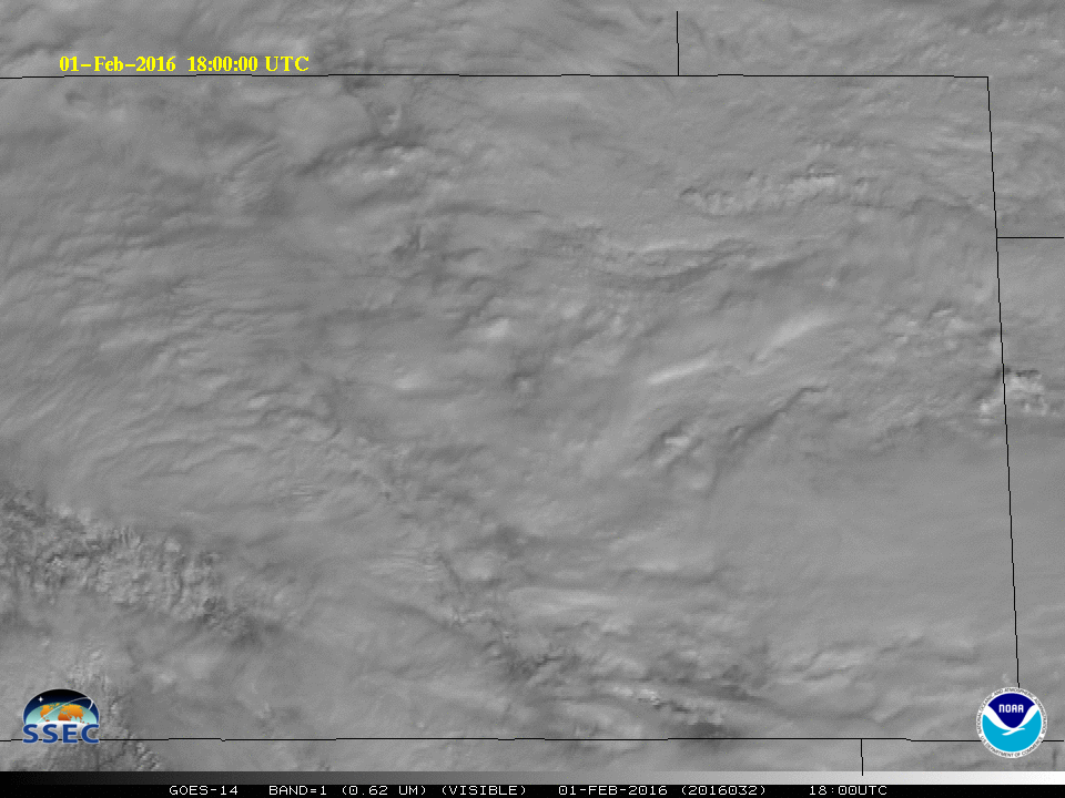
There are two animations a the top of this blog post, one with a 1-minute timestep, above, and one with a 15-minute timestep, below. The strong winter storm that hit Colorado on Monday 1 February (Blog Post) was accompanied by multiple cloud layers and snow during the day on Monday was not steady. Was it related to the holes that are present in the clouds? How easy is it to track the different clouds to predict the arrival, overhead, of a gap in the high clouds? Especially for the low clouds in eastern Colorado in this example, cloud hole tracking can be done with more confidence with 1-minute imagery. Decision Support related to short time-scale variability in snow accumulations can be done with more confidence with the 1-minute imagery.
![GOES-14 Visible (0.63 µm) images, 15-minute time-step [click to play rocking animated gif]](https://cimss.ssec.wisc.edu/satellite-blog/wp-content/uploads/sites/5/2016/02/720x960_AGOES14_B1_COVisExample_2016032_170000_2016032_2200rock15min.gif)
GOES-14 Visible (0.63 µm) images, 15-minute time-step [click to play rocking animated gif]
===============================================================================
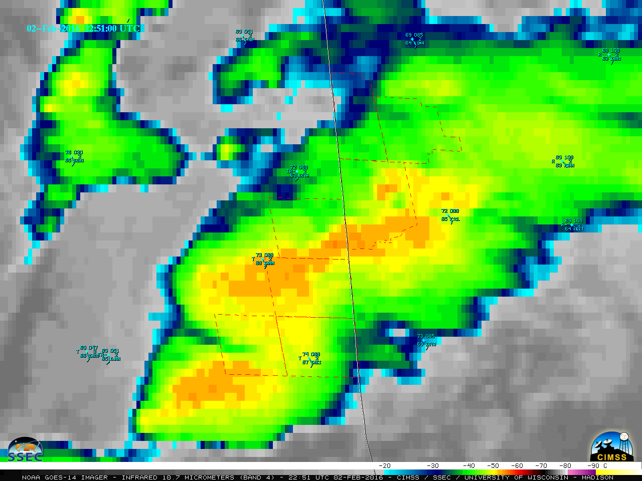
On 7 February 2016, GOES-14 in SRSO-R monitored the development of a very strong storm over the Atlantic Ocean (blog post) east of the United States. Consider the animations below, starting with the standard GOES-East time steps (nominally every 15 minutes with some gaps). If you are monitoring the storm development, or the motion of the individual convective clouds, the 15-minute temporal gaps are insufficient for confident detection of cloud motions. When, for example, does the surface circulation first appear? Do the cloud towers that appear in the 15-minute animation persist over the course of 15 minutes, or do they decay and reappear? In the succeeding animations below, at 5- and 1-minute intervals, increasing amounts of detail are present because the better temporal resolution is convincingly following features. Additionally, the precise timing of events is better captured.
![GOES-14 Visible (0.63 µm) images, 15-minute time-step [click to play animated gif]](https://cimss.ssec.wisc.edu/satellite-blog/wp-content/uploads/sites/5/2016/02/960x1280_AGOES14_B1_AtlBight7Feb_2016038_124500_22150015min_anim.gif)
GOES-14 Visible (0.63 µm) images, 15-minute time-step [click to play animated gif]
![GOES-14 Visible (0.63 µm) images, 15-minute time-step [click to play animated gif]](https://cimss.ssec.wisc.edu/satellite-blog/wp-content/uploads/sites/5/2016/02/960x1280_AGOES14_B1_AtlBight7Feb_2016038_124500_2215005min_anim.gif)
GOES-14 Visible (0.63 µm) images, 5-minute time-step [click to play animated gif]
![GOES-14 Visible (0.63 µm) images, 15-minute time-step [click to play animated gif]](https://cimss.ssec.wisc.edu/satellite-blog/wp-content/uploads/sites/5/2016/02/960x1280_AGOES14_B1_AtlBight7Feb_2016038_124500_2215001min_anim.gif)
GOES-14 Visible (0.63 µm) images, 1-minute time-step [click to play animated gif]
The differences between 1-, 5- and 15-minute time steps are visualized in the rocking animation below. The right-most panel has a 15-minute timestep always, the middle panel starts with a 15-minute time step before switching to 5-minute, and the left-most panel shows 15-minute, 5-minute and 1-minute time steps. Note how the convective towers appear and disappear on timescales that make resolution in the 5-minute time step difficult and in the 15-minute timestep impossible. The region below is excised from the animations above, and is over the ocean south of the developing low pressure system.
![GOES-14 Visible (0.63 µm) images, 15-minute time-step (right panel), 15-minute then 5-minute time step (middle panel) and 15-minute, then 5-minute, then 1-minute time step (left panel) [click to play animated gif]](https://cimss.ssec.wisc.edu/satellite-blog/wp-content/uploads/sites/5/2016/02/3panel_AGOES14_B1_AtlBight_7Feb2016038_1400_1445_3wayRockanim.gif)
GOES-14 Visible (0.63 µm) images, 15-minute time-step (right panel), 15-minute then 5-minute time step (middle panel) and 15-minute, then 5-minute, then 1-minute time step (left panel) [click to play animated gif]
View only this post Read Less
![GOES-14 Visible (0.63 µm) images [click to play MP4 animation]](https://cimss.ssec.wisc.edu/satellite-blog/wp-content/uploads/sites/5/2016/02/960x1280_GOES14_B1_GOES14_VIS_WI_IL_TSSN_2016033_143400_0001PANEL.GIF)
![GOES-14 Infrared Window (10.7 µm) images [click to play MP4 animation]](https://cimss.ssec.wisc.edu/satellite-blog/wp-content/uploads/sites/5/2016/02/800x800_AGOES14_B4_AL_CONV_2016034_080000.GIF)
![GOES-14 Visible (0.63 µm) images [click to play MP4 animation]](https://cimss.ssec.wisc.edu/satellite-blog/wp-content/uploads/sites/5/2016/02/960x1280_GOES14_B1_GOES14_VIS_MS_AL_ZOOM_2016033_225100_0001PANEL.GIF)
![GOES-14 Infrared Window (10.7 µm) images [click to play MP4 animation]](https://cimss.ssec.wisc.edu/satellite-blog/wp-content/uploads/sites/5/2016/02/960x1280_GOES14_B4_GOES14_IR4_MS_AL_ZOOM_2016033_225100_0001PANEL.GIF)

![GOES-14 Visible (0.63 µm) images, with surface observations [click to play MP4 animation]](https://cimss.ssec.wisc.edu/satellite-blog/wp-content/uploads/sites/5/2016/02/960x1280_GOES14_B1_GOES14_VIS_TX_RETURN_FLOW_2016032_151800_0001PANEL.GIF)
![GOES-14 Visible (0.63 µm) images, with surface reports [click to play MP4 animation]](https://cimss.ssec.wisc.edu/satellite-blog/wp-content/uploads/sites/5/2016/02/960x1280_GOES14_B1_GOES14_VIS_TX_MEX_BLDN_2016032_231500_0001PANEL.GIF)
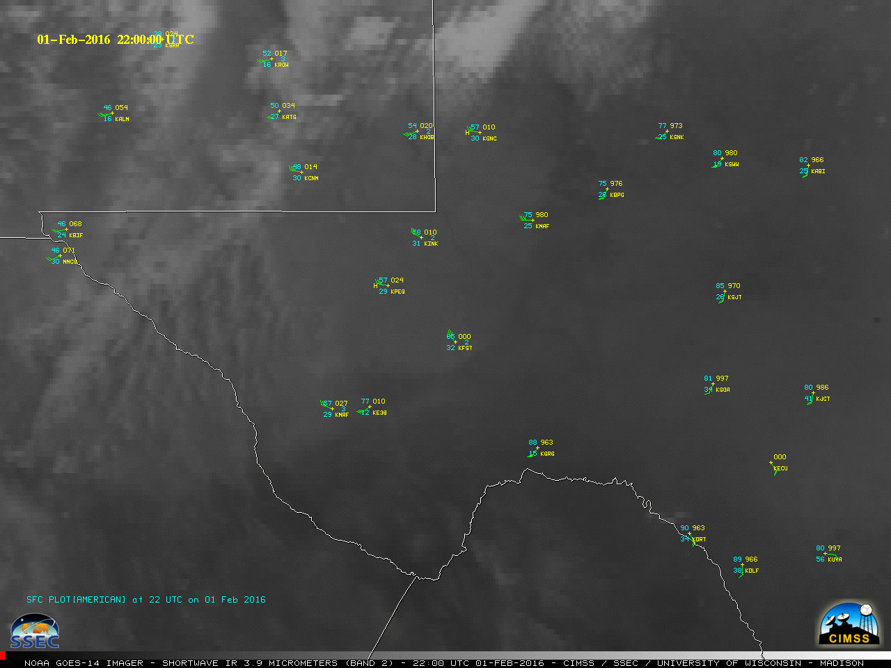
![GOES-14 Shortwave Infrared (3.9 µm) images [click to play MP4 animation]](https://cimss.ssec.wisc.edu/satellite-blog/wp-content/uploads/sites/5/2016/02/960x1280_GOES14_B2_GOES14_IR2_TX_MEX_BLDN_2016032_234600_0001PANEL.GIF)
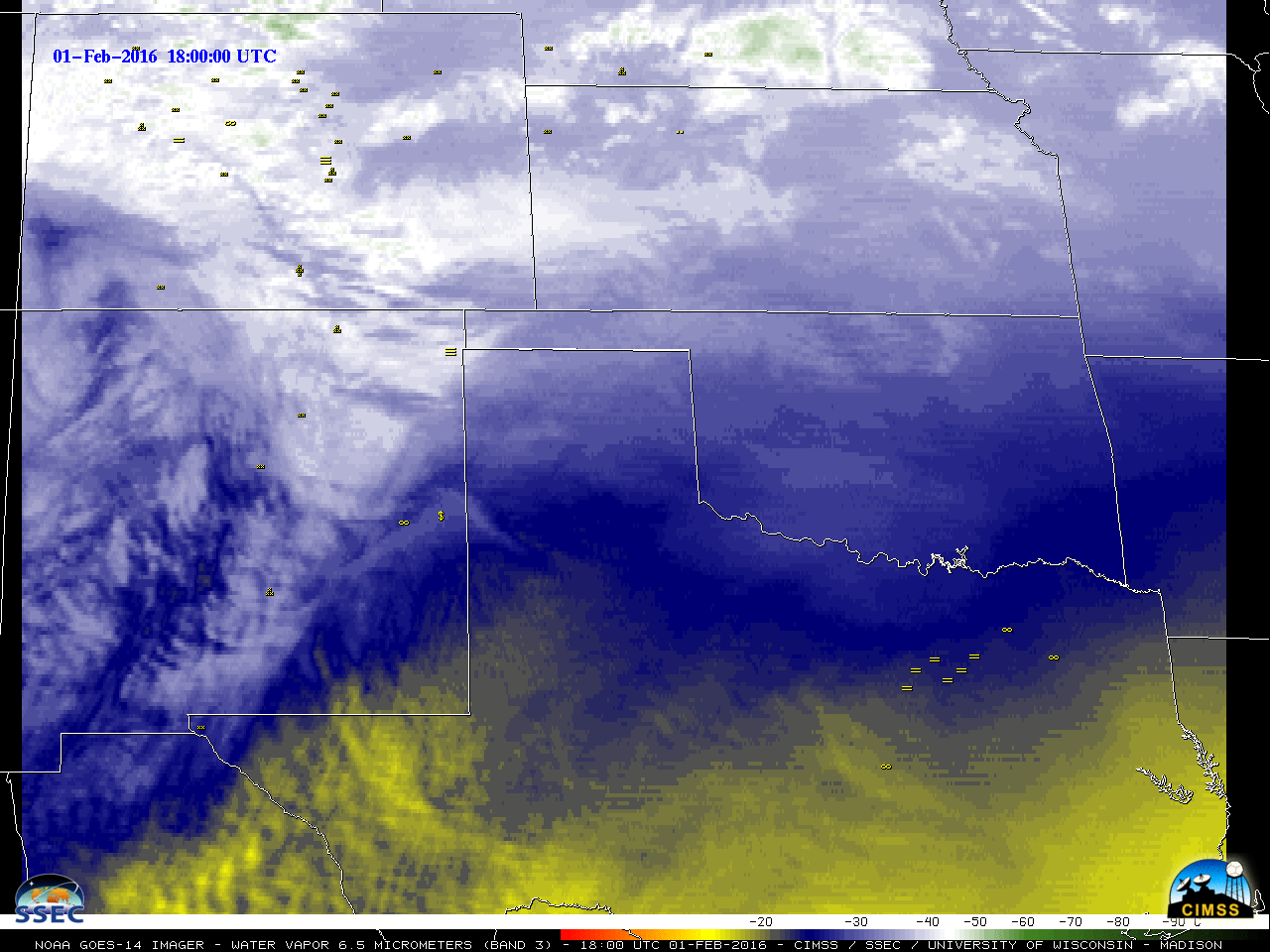
![GOES-14 Water Vapor (6.5 µm) images, with surface weather symbols [click to play MP4 animation]](https://cimss.ssec.wisc.edu/satellite-blog/wp-content/uploads/sites/5/2016/02/960x1280_GOES14_B3_GOES14_WV_CO_TX_2016032_230200_0001PANEL.GIF)
![GOES-14 Shortwave Infrared (3.9 µm) images [click to play MP4 animation]](https://cimss.ssec.wisc.edu/satellite-blog/wp-content/uploads/sites/5/2016/02/960x1280_GOES14_B2_GOES14_IR2_TX_UNDULAR_BORE_2016033_091700_0001PANEL.GIF)
![Suomi NPP VIIRS Day/Night Band (0.7 µm) and Infrared Window (11.45 µm) images [click to enlarge]](https://cimss.ssec.wisc.edu/satellite-blog/wp-content/uploads/sites/5/2016/02/160202_0859utc_suomi_npp_viirs_dnb_ir_TX_undular_bore_anim.gif)
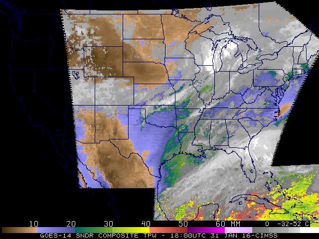
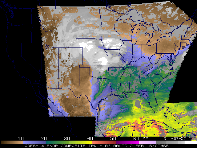
![GOES-14 Sounder DPI of Total Precipitable Water (TPW) at 1800 UTC on 31 January 2016 [Click to enlarge]](https://cimss.ssec.wisc.edu/satellite-blog/wp-content/uploads/sites/5/2016/01/uspwag14_li_gfsm_maba.16031.1800.gif)
