This website works best with a newer web browser such as Chrome, Firefox, Safari or Microsoft Edge. Internet Explorer is not supported by this website.

Wave Clouds over the Bay of Fundy

Wave clouds downstream of mountain ridges are a fairly common sight for regular observers of satellite data. See, for example, the parallel bands of clouds over southern Virginia in this image from the Record-setting Nor’easter in April of 2007. Such clouds develop as air is forced upward by the ridges of the... Read More

Wave clouds downstream of mountain ridges are a fairly common sight for regular observers of satellite data. See, for example, the parallel bands of clouds over southern Virginia in this image from the Record-setting Nor’easter in April of 2007. Such clouds develop as air is forced upward by the ridges of the Appalachian mountains. A standing wave develops, usually downstream of the mountain ridge, with clouds in the region of upward motion (if moisture is sufficient to allow for condensation) and clearing in regions of downward motion.

An excellent example of Wave Clouds occurred August 9th over the Bay of Fundy, in the Canadian Maritimes. The region is not noted for its tall mountains; however, the Caledonia Hills parallel the north shore of the Bay of Fundy, and North Mountain is along the south shore of the Bay of Fundy in Nova Scotia. (As shown here). The clouds formed in the northwest flow behind a departing low pressure system and gradually dissipated during the day as downward motion behind the departing the storm increased.

brunswick_wave_1302.gif

(Click on the image for a loop — note how the parallel bands of clouds are stationary). Clouds of this type generally are capped by an inversion, and such was the case on this day. This link shows the upper-air sounding from Yarmouth, on the southeast coast of Nova Scotia. An inversion exists above strong north-northwesterly winds that would be perpendicular to the coastline and the mountains that parallel the coast. The Caledonian Mountains along the coast of the Bay of Fundy aren’t particularly tall (they’re mostly below 400m at their peaks). The mountains on the north shore of Nova Scotia that surround the Annapolis Valley are also of modest height (less than 400 m). They are tall enough, however, to cause the atmospheric motions that give rise to the Wave Clouds in the images.

View only this post Read Less
Wildfire in the Upper Peninsula of Michigan

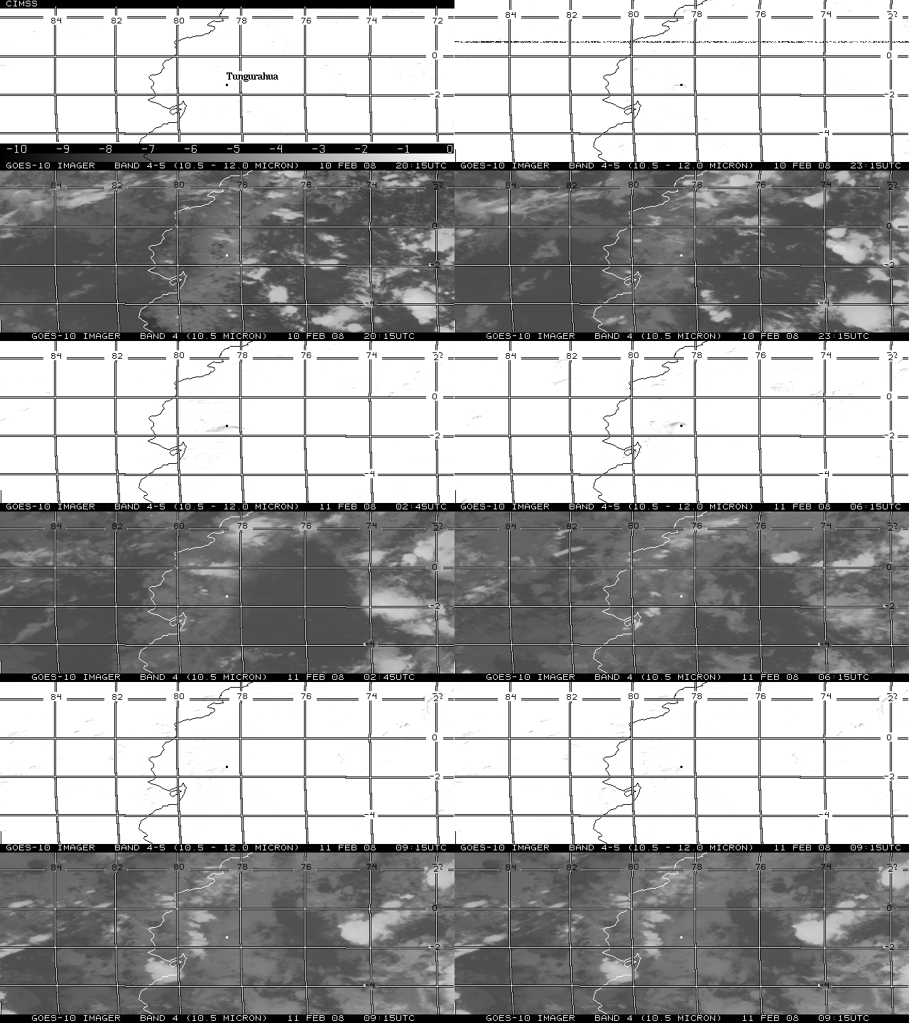
A Java animation of GOES-12 (above; upper panels) and GOES-13 (above; lower panels) visible channel and 3.9 µm IR images showed a smoke plume (drifting southeastward) and “hot spots” (black-enhanced IR pixels) associated with a large wildfire that was burning the the eastern portion of the Upper Peninsula of Michigan on 03 August 2007.... Read More

GOES-12 / GOES-13 visible/IR images (Java animation)

A Java animation of GOES-12 (above; upper panels) and GOES-13 (above; lower panels) visible channel and 3.9 µm IR images showed a smoke plume (drifting southeastward) and “hot spots” (black-enhanced IR pixels) associated with a large wildfire that was burning the the eastern portion of the Upper Peninsula of Michigan on 03 August 2007. Note the improvement evident with changes to the image navigation and registration (INR) on the GOES-13 satellite: the coastline features and the fire hot spots remain fairly steady from image to image, compared to the GOES-12 images which exhibit a good deal of “wobble” in the animation.

The smoke plume was clearly depicted on Aqua MODIS true color imagery (below), drifting southeastward across northern Lake Huron. The fire (likely started by lightning on 02 August) was reported to have burned about 5000 acres by late afternoon, and was spreading southeastward at the rate of more than 1 mile per hour through uninhabited marshland north of Newberry, Michigan.

Aqua MODIS true color image

View only this post Read Less

Smoke and haze along cold frontal boundary

A cold frontal boundary was moving southeastward through the Great Lakes region on 02 August 2007; Terra MODIS true color imagery (above) showed a very hazy air mass along and ahead of the advancing frontal boundary, with a very clean air mass behind the front. The dew point temperature at Madison, Wisconsin... Read More

Terra MODIS true color image

A cold frontal boundary was moving southeastward through the Great Lakes region on 02 August 2007; Terra MODIS true color imagery (above) showed a very hazy air mass along and ahead of the advancing frontal boundary, with a very clean air mass behind the front. The dew point temperature at Madison, Wisconsin dropped from 70º F to 42º F in the 24-hour period following the frontal passage. Also evident on the MODIS image is a thin light-colored streak (oriented southwest-to-northeast) across northeastern Wisconsin, which was the damage path from a long-track tornado that occurred nearly 2 months earlier on 07 June 2007.

The IDEA MODIS aerosol optical depth (AOD) product several days earlier (below) revealed a high AOD signal (orange to red enhancement) over the northern Rocky Mountains region, due to thick smoke from numerous wildfires that were burning in Idaho and western Montana. Much of this smoke was subsequently transported eastward along the cold frontal boundary (MODIS AOD image Java animation).

MODIS aerosol optical depth product

View only this post Read Less
Cold water eddies and ice floes in Hudson Bay

Our recent fascination with the MODIS Sea Surface Temperature (SST) product continues, with AWIPS imagery of the MODIS SST that revealed an intricate pattern of cold water eddies across the southern portion of Hudson Bay in Canada on 30 July 2007 (above; upper left panel). The 2 MODIS image sets are about 90... Read More

AWIPS MODIS imagery (Animated GIF)

Our recent fascination with the MODIS Sea Surface Temperature (SST) product continues, with AWIPS imagery of the MODIS SST that revealed an intricate pattern of cold water eddies across the southern portion of Hudson Bay in Canada on 30 July 2007 (above; upper left panel). The 2 MODIS image sets are about 90 minutes apart, and the image animation indicates that these cold water eddies were moving rather rapidly westward during that short time interval — this water feature motion was in the opposite direction of the boundary layer winds, which were light westerly to northwesterly around the northern periphery of a surface anticyclone that was centered over northern Ontario.

There were patches of low-level cloudiness over the water in the eastern and western portions of the satellite scene — these clouds showed up as darker (warmer) features on the MODIS 3.7µm IR images (above; lower right panel) due to the solar radiation reflected off the tops of these water droplet clouds. If you look closely, you can also see several small white “specks” in the water near the middle of the MODIS visible images (above; lower left panel) which were also moving westward — these were small ice floes that were floating in the still-cold waters of Hudson Bay (the coldest SST values seen in that area on this day were around 37º F or +3º C, dark blue enhancement). The ice floes did not exhibit a darker signal on the MODIS 3.7µm IR image, since the component of solar radiation reflected off ice surfaces is minimal.

MODIS false color visible images (Animated GIF)

These small ice floes were more clearly depicted in false-color composite images using the 250-meter resolution visible channels 1 and 2 from the Terra abd Aqua MODIS instruments (above). Hudson Bay retained significant ice cover well into the month of June 2007 (MODIS true color image | MODIS false color image: ice features have a red enhancement), and a good deal of ice was still present as recently as early July 2007 (MODIS true color image | MODIS false color image: ice features have a red enhancement).

A comparison of GOES-13 and GOES-12 visible channel images (Java animation, below) better showed the motion of these ice floes during the 6-hour period from 14:02-20:15 UTC. Note the improved image navigation and registration (INR) evident with the GOES-13 satellite: the coastline and island features remain fairly steady from image to image, in contrast with the GOES-12 images which exhibit a notable amount of “wobble” in the animation. Using McIDAS, we tracked the speed of 2 different ice floe features on the GOES-13 imagery: one of the fastest-moving ice floes was seen to have a speed of about 1.8 kilometers per hour (1 knot), while most of the other ice floes seemed to be moving more slowly at a speed of around 0.5 kilometers per hour (0.3 knots). Using the AWIPS “Distance Speed” tool, the speed of displacement of the ice floes and cold water eddies between the 2 MODIS images was found to be about 3 kilometers per hour (2 knots).

GOES-13 / GOES-12 visible images (Java animation)

View only this post Read Less