
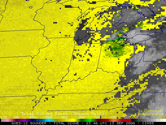
A QuickTime animation of GOES-12 imager 6.5 micrometer (“water vapor channel”) imagery (above) reveals an interesting vortex associated with a cutoff upper-level low which was migrating eastward from Illinois to Ohio on 13 Sepember. Several pulses of convection can be seen developing along the periphery of the vortex. In addition, GOES-12 sounder total column ozone values were slightly elevated within the core of the vortex (~350 Dobson Units, compared to the background of ~300 DU), suggesting that some stratospheric air was also present.
Also of interest were the subtle indications that the structure of the jet stream (within the southeastern quadrant of the upper low circulation) was very complex — note the “streaky” appearance on the water vapor images across the Tennessee and Ohio River Valley regions, especially evident on the 1km resolution MODIS water vapor channel (below, upper right panel), but also apparent on the 10km resolution GOES-12 sounder water vapor channel (below, lower left panel). The relatively smooth NAM 300mb wind speeds simply indicated a broad jet streak core oriented SW-NE from Mississippi to Virginia, with a 500mb jet streak axis located farther to the northwest. The striated appearance of the water vapor imagery suggests that the broad jet core region may have been comprised of multiple jet streaks (likely existing at different altitudes).
The lower right panel below is the CRAS model forecast of the GOES water vapor channel, close to the time of the actual satellite images in the other 3 panels; while the CRAS model was unable to resolve the fine mesoscale structure associated with the multiple jet streak cores, it did offer a good prognosis of the “3-pronged structure” of the leading edge of the dry slot.

View only this post Read Less


")
